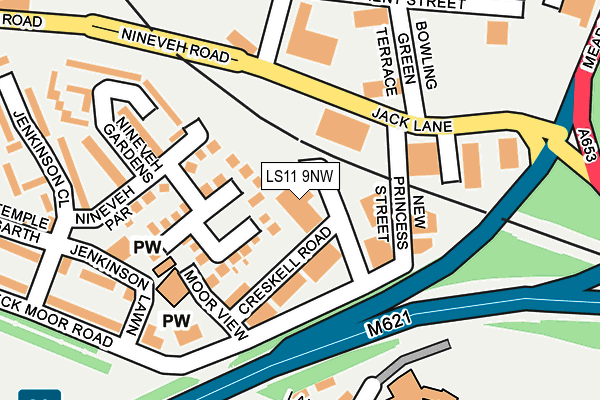
LS11 9NW is located in the Beeston & Holbeck electoral ward, within the metropolitan district of Leeds and the English Parliamentary constituency of Leeds Central. The Sub Integrated Care Board (ICB) Location is NHS West Yorkshire ICB - 15F and the police force is West Yorkshire. This postcode has been in use since January 1980.


GetTheData
Source: OS OpenMap – Local (Ordnance Survey)
Source: OS VectorMap District (Ordnance Survey)
Licence: Open Government Licence (requires attribution)
| Easting | 429603 |
| Northing | 432216 |
| Latitude | 53.785446 |
| Longitude | -1.552192 |
GetTheData
Source: Open Postcode Geo
Licence: Open Government Licence
| Country | England |
| Postcode District | LS11 |
➜ See where LS11 is on a map ➜ Where is Leeds? | |
GetTheData
Source: Land Registry Price Paid Data
Licence: Open Government Licence
Elevation or altitude of LS11 9NW as distance above sea level:
| Metres | Feet | |
|---|---|---|
| Elevation | 30m | 98ft |
Elevation is measured from the approximate centre of the postcode, to the nearest point on an OS contour line from OS Terrain 50, which has contour spacing of ten vertical metres.
➜ How high above sea level am I? Find the elevation of your current position using your device's GPS.
GetTheData
Source: Open Postcode Elevation
Licence: Open Government Licence
| Ward | Beeston & Holbeck |
| Constituency | Leeds Central |
GetTheData
Source: ONS Postcode Database
Licence: Open Government Licence
| Lady Pit Ln Northcote Green (Lady Pit Lane) | Beeston Hill | 377m |
| Lady Pit Ln Northcote Green (Lady Pit Lane) | Beeston Hill | 388m |
| Lady Pit Ln Folly Lane (Lady Pit Lane) | Beeston Hill | 489m |
| Top Moor Side | Holbeck | 491m |
| Top Moor Side | Holbeck | 495m |
| Leeds Station | 1.2km |
| Cottingley Station | 3.1km |
| Burley Park Station | 3.4km |
GetTheData
Source: NaPTAN
Licence: Open Government Licence
GetTheData
Source: ONS Postcode Database
Licence: Open Government Licence


➜ Get more ratings from the Food Standards Agency
GetTheData
Source: Food Standards Agency
Licence: FSA terms & conditions
| Last Collection | |||
|---|---|---|---|
| Location | Mon-Fri | Sat | Distance |
| Holbeck Do | 105m | ||
| Holbeck Towers | 17:30 | 11:00 | 246m |
| 10 Hunslet Hall Road | 17:30 | 11:00 | 404m |
GetTheData
Source: Dracos
Licence: Creative Commons Attribution-ShareAlike
The below table lists the International Territorial Level (ITL) codes (formerly Nomenclature of Territorial Units for Statistics (NUTS) codes) and Local Administrative Units (LAU) codes for LS11 9NW:
| ITL 1 Code | Name |
|---|---|
| TLE | Yorkshire and The Humber |
| ITL 2 Code | Name |
| TLE4 | West Yorkshire |
| ITL 3 Code | Name |
| TLE42 | Leeds |
| LAU 1 Code | Name |
| E08000035 | Leeds |
GetTheData
Source: ONS Postcode Directory
Licence: Open Government Licence
The below table lists the Census Output Area (OA), Lower Layer Super Output Area (LSOA), and Middle Layer Super Output Area (MSOA) for LS11 9NW:
| Code | Name | |
|---|---|---|
| OA | E00170055 | |
| LSOA | E01033032 | Leeds 082F |
| MSOA | E02002411 | Leeds 082 |
GetTheData
Source: ONS Postcode Directory
Licence: Open Government Licence
| LS11 9BA | New Princess Street | 78m |
| LS11 9QJ | Sandlewood Green | 80m |
| LS11 9QH | Sandlewood Close | 118m |
| LS11 9QQ | Nineveh Parade | 148m |
| LS11 8RP | Beeston Road | 186m |
| LS11 9QF | Nineveh Gardens | 212m |
| LS11 9QU | Gaitskell Walk | 250m |
| LS11 9NJ | Meynell Walk | 295m |
| LS11 6NJ | Northcote Drive | 320m |
| LS11 9QA | Meynell Square | 326m |
GetTheData
Source: Open Postcode Geo; Land Registry Price Paid Data
Licence: Open Government Licence