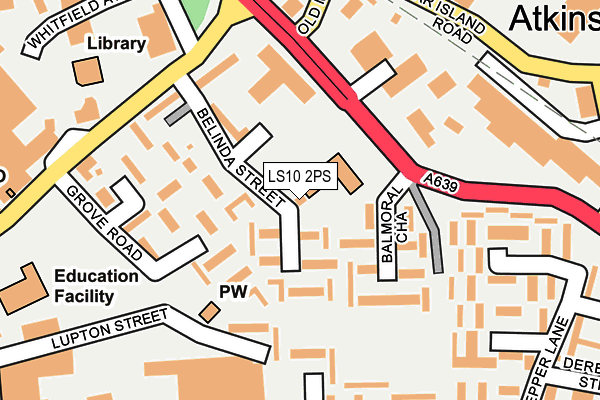
LS10 2PS is located in the Hunslet & Riverside electoral ward, within the metropolitan district of Leeds and the English Parliamentary constituency of Leeds Central. The Sub Integrated Care Board (ICB) Location is NHS West Yorkshire ICB - 15F and the police force is West Yorkshire. This postcode has been in use since January 1980.


GetTheData
Source: OS OpenMap – Local (Ordnance Survey)
Source: OS VectorMap District (Ordnance Survey)
Licence: Open Government Licence (requires attribution)
| Easting | 431442 |
| Northing | 431441 |
| Latitude | 53.778373 |
| Longitude | -1.524360 |
GetTheData
Source: Open Postcode Geo
Licence: Open Government Licence
| Country | England |
| Postcode District | LS10 |
➜ See where LS10 is on a map ➜ Where is Leeds? | |
GetTheData
Source: Land Registry Price Paid Data
Licence: Open Government Licence
Elevation or altitude of LS10 2PS as distance above sea level:
| Metres | Feet | |
|---|---|---|
| Elevation | 30m | 98ft |
Elevation is measured from the approximate centre of the postcode, to the nearest point on an OS contour line from OS Terrain 50, which has contour spacing of ten vertical metres.
➜ How high above sea level am I? Find the elevation of your current position using your device's GPS.
GetTheData
Source: Open Postcode Elevation
Licence: Open Government Licence
| Ward | Hunslet & Riverside |
| Constituency | Leeds Central |
GetTheData
Source: ONS Postcode Database
Licence: Open Government Licence
| Low Road Balmoral Chase (Low Road) | Hunslet | 126m |
| Low Rd Old Mill Lane (Low Road) | Hunslet | 132m |
| Church Street Belinda St (Church Street) | Hunslet | 172m |
| Church Street Grove Rd (Church Street) | Hunslet | 246m |
| Midland Rd Midland Close (Midland Road) | Hunslet | 258m |
| Leeds Station | 2.5km |
| Cottingley Station | 4.3km |
| Burley Park Station | 5.1km |
GetTheData
Source: NaPTAN
Licence: Open Government Licence
GetTheData
Source: ONS Postcode Database
Licence: Open Government Licence


➜ Get more ratings from the Food Standards Agency
GetTheData
Source: Food Standards Agency
Licence: FSA terms & conditions
| Last Collection | |||
|---|---|---|---|
| Location | Mon-Fri | Sat | Distance |
| Balmoral Chase/Low Road | 17:30 | 12:45 | 102m |
| Waterloo Road P.o. | 17:30 | 12:30 | 283m |
| Thwaite Gate P.o. | 17:30 | 12:30 | 498m |
GetTheData
Source: Dracos
Licence: Creative Commons Attribution-ShareAlike
The below table lists the International Territorial Level (ITL) codes (formerly Nomenclature of Territorial Units for Statistics (NUTS) codes) and Local Administrative Units (LAU) codes for LS10 2PS:
| ITL 1 Code | Name |
|---|---|
| TLE | Yorkshire and The Humber |
| ITL 2 Code | Name |
| TLE4 | West Yorkshire |
| ITL 3 Code | Name |
| TLE42 | Leeds |
| LAU 1 Code | Name |
| E08000035 | Leeds |
GetTheData
Source: ONS Postcode Directory
Licence: Open Government Licence
The below table lists the Census Output Area (OA), Lower Layer Super Output Area (LSOA), and Middle Layer Super Output Area (MSOA) for LS10 2PS:
| Code | Name | |
|---|---|---|
| OA | E00057827 | |
| LSOA | E01011467 | Leeds 112A |
| MSOA | E02006876 | Leeds 112 |
GetTheData
Source: ONS Postcode Directory
Licence: Open Government Licence
| LS10 2PX | Belinda Street | 65m |
| LS10 2PY | Belinda Street | 69m |
| LS10 2QJ | Balmoral Chase | 90m |
| LS10 2PG | Hemingway Garth | 96m |
| LS10 2PR | Belinda Street | 104m |
| LS10 2QH | Balmoral Chase | 127m |
| LS10 2QR | Lupton Street | 134m |
| LS10 2PF | Hemingway Close | 145m |
| LS10 1RH | Low Road | 149m |
| LS10 2PE | Church Street | 153m |
GetTheData
Source: Open Postcode Geo; Land Registry Price Paid Data
Licence: Open Government Licence