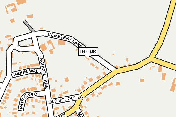
LN7 6JR lies on Pelham View in North Kelsey, Market Rasen. LN7 6JR is located in the Kelsey Wold electoral ward, within the local authority district of West Lindsey and the English Parliamentary constituency of Gainsborough. The Sub Integrated Care Board (ICB) Location is NHS Lincolnshire ICB - 71E and the police force is Lincolnshire. This postcode has been in use since January 1980.


GetTheData
Source: OS OpenMap – Local (Ordnance Survey)
Source: OS VectorMap District (Ordnance Survey)
Licence: Open Government Licence (requires attribution)
| Easting | 504505 |
| Northing | 401988 |
| Latitude | 53.504209 |
| Longitude | -0.425830 |
GetTheData
Source: Open Postcode Geo
Licence: Open Government Licence
| Street | Pelham View |
| Locality | North Kelsey |
| Town/City | Market Rasen |
| Country | England |
| Postcode District | LN7 |
➜ See where LN7 is on a map ➜ Where is North Kelsey? | |
GetTheData
Source: Land Registry Price Paid Data
Licence: Open Government Licence
Elevation or altitude of LN7 6JR as distance above sea level:
| Metres | Feet | |
|---|---|---|
| Elevation | 10m | 33ft |
Elevation is measured from the approximate centre of the postcode, to the nearest point on an OS contour line from OS Terrain 50, which has contour spacing of ten vertical metres.
➜ How high above sea level am I? Find the elevation of your current position using your device's GPS.
GetTheData
Source: Open Postcode Elevation
Licence: Open Government Licence
| Ward | Kelsey Wold |
| Constituency | Gainsborough |
GetTheData
Source: ONS Postcode Database
Licence: Open Government Licence
| Cemetery Lane (High Street) | North Kelsey | 89m |
| Cemetery Lane (High Street) | North Kelsey | 99m |
| Demand Responsive Area | North Kelsey | 302m |
| Brigg Station | 6.4km |
GetTheData
Source: NaPTAN
Licence: Open Government Licence
| Percentage of properties with Next Generation Access | 100.0% |
| Percentage of properties with Superfast Broadband | 100.0% |
| Percentage of properties with Ultrafast Broadband | 0.0% |
| Percentage of properties with Full Fibre Broadband | 0.0% |
Superfast Broadband is between 30Mbps and 300Mbps
Ultrafast Broadband is > 300Mbps
| Median download speed | 38.9Mbps |
| Average download speed | 39.6Mbps |
| Maximum download speed | 69.50Mbps |
| Median upload speed | 6.6Mbps |
| Average upload speed | 6.4Mbps |
| Maximum upload speed | 15.01Mbps |
| Percentage of properties unable to receive 2Mbps | 0.0% |
| Percentage of properties unable to receive 5Mbps | 0.0% |
| Percentage of properties unable to receive 10Mbps | 0.0% |
| Percentage of properties unable to receive 30Mbps | 0.0% |
GetTheData
Source: Ofcom
Licence: Ofcom Terms of Use (requires attribution)
Estimated total energy consumption in LN7 6JR by fuel type, 2015.
| Consumption (kWh) | 21,650 |
|---|---|
| Meter count | 6 |
| Mean (kWh/meter) | 3,608 |
| Median (kWh/meter) | 3,783 |
GetTheData
Source: Postcode level gas estimates: 2015 (experimental)
Source: Postcode level electricity estimates: 2015 (experimental)
Licence: Open Government Licence
GetTheData
Source: ONS Postcode Database
Licence: Open Government Licence

➜ Get more ratings from the Food Standards Agency
GetTheData
Source: Food Standards Agency
Licence: FSA terms & conditions
| Last Collection | |||
|---|---|---|---|
| Location | Mon-Fri | Sat | Distance |
| North Kelsey P.o. | 16:00 | 11:00 | 310m |
| Howsham Village | 16:00 | 10:00 | 2,295m |
| North Kelsey Moor | 16:15 | 08:30 | 2,531m |
GetTheData
Source: Dracos
Licence: Creative Commons Attribution-ShareAlike
The below table lists the International Territorial Level (ITL) codes (formerly Nomenclature of Territorial Units for Statistics (NUTS) codes) and Local Administrative Units (LAU) codes for LN7 6JR:
| ITL 1 Code | Name |
|---|---|
| TLF | East Midlands (England) |
| ITL 2 Code | Name |
| TLF3 | Lincolnshire |
| ITL 3 Code | Name |
| TLF30 | Lincolnshire CC |
| LAU 1 Code | Name |
| E07000142 | West Lindsey |
GetTheData
Source: ONS Postcode Directory
Licence: Open Government Licence
The below table lists the Census Output Area (OA), Lower Layer Super Output Area (LSOA), and Middle Layer Super Output Area (MSOA) for LN7 6JR:
| Code | Name | |
|---|---|---|
| OA | E00134056 | |
| LSOA | E01026387 | West Lindsey 001C |
| MSOA | E02005492 | West Lindsey 001 |
GetTheData
Source: ONS Postcode Directory
Licence: Open Government Licence
| LN7 6EE | Wold Gardens | 76m |
| LN7 6EF | High Street | 125m |
| LN7 6JN | Old School Lane | 139m |
| LN7 6JW | School Lane | 184m |
| LN7 6ED | Mill Lane | 199m |
| LN7 6ER | Lindum Walk | 206m |
| LN7 6EB | High Street | 242m |
| LN7 6EP | North Parade | 259m |
| LN7 6LH | Patricks Close | 261m |
| LN7 6JP | Little London | 269m |
GetTheData
Source: Open Postcode Geo; Land Registry Price Paid Data
Licence: Open Government Licence