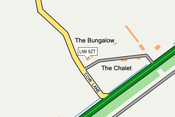
LN6 9ZT is located in the Witham St Hughs & Swinderby electoral ward, within the local authority district of North Kesteven and the English Parliamentary constituency of Sleaford and North Hykeham. The Sub Integrated Care Board (ICB) Location is NHS Lincolnshire ICB - 71E and the police force is Lincolnshire. This postcode has been in use since July 2014.


GetTheData
Source: OS OpenMap – Local (Ordnance Survey)
Source: OS VectorMap District (Ordnance Survey)
Licence: Open Government Licence (requires attribution)
| Easting | 487517 |
| Northing | 362091 |
| Latitude | 53.148780 |
| Longitude | -0.692883 |
GetTheData
Source: Open Postcode Geo
Licence: Open Government Licence
| Country | England |
| Postcode District | LN6 |
➜ See where LN6 is on a map | |
GetTheData
Source: Land Registry Price Paid Data
Licence: Open Government Licence
Elevation or altitude of LN6 9ZT as distance above sea level:
| Metres | Feet | |
|---|---|---|
| Elevation | 20m | 66ft |
Elevation is measured from the approximate centre of the postcode, to the nearest point on an OS contour line from OS Terrain 50, which has contour spacing of ten vertical metres.
➜ How high above sea level am I? Find the elevation of your current position using your device's GPS.
GetTheData
Source: Open Postcode Elevation
Licence: Open Government Licence
| Ward | Witham St Hughs & Swinderby |
| Constituency | Sleaford And North Hykeham |
GetTheData
Source: ONS Postcode Database
Licence: Open Government Licence
| The Plough Ph (High Street) | Swinderby | 912m |
| Demand Responsive Area | Swinderby | 1,002m |
| Green Lane (Halfway House Lane) | Swinderby | 1,062m |
| Lost Village Festival Site (Swinderby Road) | Witham St Hughs | 1,067m |
| Green Lane (Halfway House Lane) | Swinderby | 1,074m |
| Swinderby Station | 2.4km |
| Collingham Station | 3.9km |
GetTheData
Source: NaPTAN
Licence: Open Government Licence
GetTheData
Source: ONS Postcode Database
Licence: Open Government Licence


➜ Get more ratings from the Food Standards Agency
GetTheData
Source: Food Standards Agency
Licence: FSA terms & conditions
| Last Collection | |||
|---|---|---|---|
| Location | Mon-Fri | Sat | Distance |
| Muntjac Way | 17:15 | 11:00 | 1,956m |
| South Scarle Post Office | 16:30 | 10:00 | 3,377m |
| Swinderby Road | 16:45 | 10:30 | 3,965m |
GetTheData
Source: Dracos
Licence: Creative Commons Attribution-ShareAlike
The below table lists the International Territorial Level (ITL) codes (formerly Nomenclature of Territorial Units for Statistics (NUTS) codes) and Local Administrative Units (LAU) codes for LN6 9ZT:
| ITL 1 Code | Name |
|---|---|
| TLF | East Midlands (England) |
| ITL 2 Code | Name |
| TLF3 | Lincolnshire |
| ITL 3 Code | Name |
| TLF30 | Lincolnshire CC |
| LAU 1 Code | Name |
| E07000139 | North Kesteven |
GetTheData
Source: ONS Postcode Directory
Licence: Open Government Licence
The below table lists the Census Output Area (OA), Lower Layer Super Output Area (LSOA), and Middle Layer Super Output Area (MSOA) for LN6 9ZT:
| Code | Name | |
|---|---|---|
| OA | E00132997 | |
| LSOA | E01026193 | North Kesteven 003C |
| MSOA | E02005455 | North Kesteven 003 |
GetTheData
Source: ONS Postcode Directory
Licence: Open Government Licence
| LN6 9HR | Green Lane | 747m |
| LN6 9LP | Collingham Road | 884m |
| LN6 9HN | Newark Road | 913m |
| LN6 9LZ | Newton Close | 970m |
| LN6 9PY | Holt Farm Paddock | 972m |
| LN6 9LS | Manor Road | 1066m |
| LN6 9LW | High Street | 1082m |
| LN6 9LX | Moor Lane | 1136m |
| LN6 9LU | High Street | 1154m |
| LN6 9HP | Halfway Lane | 1162m |
GetTheData
Source: Open Postcode Geo; Land Registry Price Paid Data
Licence: Open Government Licence