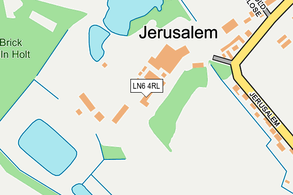
LN6 4RL is located in the Skellingthorpe & Eagle electoral ward, within the local authority district of North Kesteven and the English Parliamentary constituency of Lincoln. The Sub Integrated Care Board (ICB) Location is NHS Lincolnshire ICB - 71E and the police force is Lincolnshire. This postcode has been in use since April 2010.


GetTheData
Source: OS OpenMap – Local (Ordnance Survey)
Source: OS VectorMap District (Ordnance Survey)
Licence: Open Government Licence (requires attribution)
| Easting | 491512 |
| Northing | 370994 |
| Latitude | 53.228115 |
| Longitude | -0.630621 |
GetTheData
Source: Open Postcode Geo
Licence: Open Government Licence
| Country | England |
| Postcode District | LN6 |
➜ See where LN6 is on a map ➜ Where is Skellingthorpe? | |
GetTheData
Source: Land Registry Price Paid Data
Licence: Open Government Licence
Elevation or altitude of LN6 4RL as distance above sea level:
| Metres | Feet | |
|---|---|---|
| Elevation | 20m | 66ft |
Elevation is measured from the approximate centre of the postcode, to the nearest point on an OS contour line from OS Terrain 50, which has contour spacing of ten vertical metres.
➜ How high above sea level am I? Find the elevation of your current position using your device's GPS.
GetTheData
Source: Open Postcode Elevation
Licence: Open Government Licence
| Ward | Skellingthorpe & Eagle |
| Constituency | Lincoln |
GetTheData
Source: ONS Postcode Database
Licence: Open Government Licence
| Jerusalem Road | Jerusalem | 259m |
| Jerusalem Road | Jerusalem | 266m |
| The Holt Primary School (Swallow Avenue) | Skellingthorpe | 658m |
| The Holt Primary School (Swallow Avenue) | Skellingthorpe | 687m |
| Mallard Close (Swallow Avenue) | Skellingthorpe | 825m |
| Hykeham Station | 4.2km |
| Saxilby Station | 4.9km |
GetTheData
Source: NaPTAN
Licence: Open Government Licence
GetTheData
Source: ONS Postcode Database
Licence: Open Government Licence


➜ Get more ratings from the Food Standards Agency
GetTheData
Source: Food Standards Agency
Licence: FSA terms & conditions
| Last Collection | |||
|---|---|---|---|
| Location | Mon-Fri | Sat | Distance |
| Highfield Avenue | 17:45 | 12:30 | 3,307m |
| Harby Post Office | 16:00 | 10:30 | 3,566m |
| Pyke Road | 18:30 | 00:01 | 3,709m |
GetTheData
Source: Dracos
Licence: Creative Commons Attribution-ShareAlike
The below table lists the International Territorial Level (ITL) codes (formerly Nomenclature of Territorial Units for Statistics (NUTS) codes) and Local Administrative Units (LAU) codes for LN6 4RL:
| ITL 1 Code | Name |
|---|---|
| TLF | East Midlands (England) |
| ITL 2 Code | Name |
| TLF3 | Lincolnshire |
| ITL 3 Code | Name |
| TLF30 | Lincolnshire CC |
| LAU 1 Code | Name |
| E07000139 | North Kesteven |
GetTheData
Source: ONS Postcode Directory
Licence: Open Government Licence
The below table lists the Census Output Area (OA), Lower Layer Super Output Area (LSOA), and Middle Layer Super Output Area (MSOA) for LN6 4RL:
| Code | Name | |
|---|---|---|
| OA | E00133175 | |
| LSOA | E01026226 | North Kesteven 003F |
| MSOA | E02005455 | North Kesteven 003 |
GetTheData
Source: ONS Postcode Directory
Licence: Open Government Licence
| LN6 4RN | Jerusalem Cottages | 277m |
| LN6 4RD | Old Pits Close | 337m |
| LN6 4RH | Jerusalem Road | 495m |
| LN6 4RJ | Queensway | 602m |
| LN6 5XL | Swallow Avenue | 713m |
| LN6 5SD | Martin Close | 785m |
| LN6 5XJ | Swallow Avenue | 805m |
| LN6 5TJ | Canberra Way | 851m |
| LN6 5RB | Mitchell Close | 863m |
| LN6 5SF | Goldfinch Close | 874m |
GetTheData
Source: Open Postcode Geo; Land Registry Price Paid Data
Licence: Open Government Licence