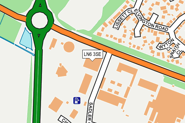
LN6 3SE lies on Doddington Road in Lincoln. LN6 3SE is located in the Hartsholme electoral ward, within the local authority district of Lincoln and the English Parliamentary constituency of Lincoln. The Sub Integrated Care Board (ICB) Location is NHS Lincolnshire ICB - 71E and the police force is Lincolnshire. This postcode has been in use since February 1990.


GetTheData
Source: OS OpenMap – Local (Ordnance Survey)
Source: OS VectorMap District (Ordnance Survey)
Licence: Open Government Licence (requires attribution)
| Easting | 492596 |
| Northing | 368688 |
| Latitude | 53.207205 |
| Longitude | -0.615057 |
GetTheData
Source: Open Postcode Geo
Licence: Open Government Licence
| Street | Doddington Road |
| Town/City | Lincoln |
| Country | England |
| Postcode District | LN6 |
➜ See where LN6 is on a map ➜ Where is Lincoln? | |
GetTheData
Source: Land Registry Price Paid Data
Licence: Open Government Licence
Elevation or altitude of LN6 3SE as distance above sea level:
| Metres | Feet | |
|---|---|---|
| Elevation | 20m | 66ft |
Elevation is measured from the approximate centre of the postcode, to the nearest point on an OS contour line from OS Terrain 50, which has contour spacing of ten vertical metres.
➜ How high above sea level am I? Find the elevation of your current position using your device's GPS.
GetTheData
Source: Open Postcode Elevation
Licence: Open Government Licence
| Ward | Hartsholme |
| Constituency | Lincoln |
GetTheData
Source: ONS Postcode Database
Licence: Open Government Licence
| Cheshire Road (Kingsley Road) | North Hykeham | 267m |
| Cheshire Road (Kingsley Road) | North Hykeham | 297m |
| Essential Depot (Sadler Road) | Doddington Park | 311m |
| Essential Depot (Sadler Road) | Doddington Park | 327m |
| Waltham Road (Pershore Way) | Doddington Park | 424m |
| Hykeham Station | 1.7km |
| Lincoln Central Station | 5.4km |
GetTheData
Source: NaPTAN
Licence: Open Government Licence
GetTheData
Source: ONS Postcode Database
Licence: Open Government Licence


➜ Get more ratings from the Food Standards Agency
GetTheData
Source: Food Standards Agency
Licence: FSA terms & conditions
| Last Collection | |||
|---|---|---|---|
| Location | Mon-Fri | Sat | Distance |
| Pyke Road | 18:30 | 00:01 | 1,378m |
| Pyke Road | 18:30 | 10:30 | 1,384m |
| High Street | 16:45 | 11:00 | 2,001m |
GetTheData
Source: Dracos
Licence: Creative Commons Attribution-ShareAlike
The below table lists the International Territorial Level (ITL) codes (formerly Nomenclature of Territorial Units for Statistics (NUTS) codes) and Local Administrative Units (LAU) codes for LN6 3SE:
| ITL 1 Code | Name |
|---|---|
| TLF | East Midlands (England) |
| ITL 2 Code | Name |
| TLF3 | Lincolnshire |
| ITL 3 Code | Name |
| TLF30 | Lincolnshire CC |
| LAU 1 Code | Name |
| E07000138 | Lincoln |
GetTheData
Source: ONS Postcode Directory
Licence: Open Government Licence
The below table lists the Census Output Area (OA), Lower Layer Super Output Area (LSOA), and Middle Layer Super Output Area (MSOA) for LN6 3SE:
| Code | Name | |
|---|---|---|
| OA | E00132816 | |
| LSOA | E01026163 | Lincoln 009F |
| MSOA | E02005450 | Lincoln 009 |
GetTheData
Source: ONS Postcode Directory
Licence: Open Government Licence
| LN6 3PW | Checkpoint Court | 114m |
| LN6 0SY | Lissett Close | 146m |
| LN6 0SZ | Elvington Close | 147m |
| LN6 0SP | Elvington Road | 226m |
| LN6 0SW | Wyton Close | 229m |
| LN6 0SR | Snaith Close | 259m |
| LN6 0SX | Langer Close | 281m |
| LN6 0SD | Waltham Road | 319m |
| LN6 0SU | Chedburgh Close | 347m |
| LN6 0SQ | Graveley Close | 347m |
GetTheData
Source: Open Postcode Geo; Land Registry Price Paid Data
Licence: Open Government Licence