LN4 1AQ maps, stats, and open data
LN4 1AQ lies on Bardney Road in Washingborough, Lincoln. LN4 1AQ is located in the Heighington & Washingborough electoral ward, within the local authority district of North Kesteven and the English Parliamentary constituency of Sleaford and North Hykeham. The Sub Integrated Care Board (ICB) Location is NHS Lincolnshire ICB - 71E and the police force is Lincolnshire. This postcode has been in use since January 1980.
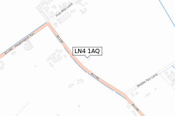
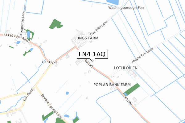
LN4 1AQ maps


Licence: Open Government Licence (requires attribution)
Attribution: Contains OS data © Crown copyright and database right 2025
Source: Open Postcode Geo
Licence: Open Government Licence (requires attribution)
Attribution: Contains OS data © Crown copyright and database right 2025; Contains Royal Mail data © Royal Mail copyright and database right 2025; Source: Office for National Statistics licensed under the Open Government Licence v.3.0
LN4 1AQ geodata
| Easting | 505136 |
| Northing | 370130 |
| Latitude | 53.217833 |
| Longitude | -0.426899 |
Where is LN4 1AQ?
| Street | Bardney Road |
| Locality | Washingborough |
| Town/City | Lincoln |
| Country | England |
| Postcode District | LN4 |
LN4 1AQ Elevation
Elevation or altitude of LN4 1AQ as distance above sea level:
| Metres | Feet | |
|---|---|---|
| Elevation | 10m | 33ft |
Elevation is measured from the approximate centre of the postcode, to the nearest point on an OS contour line from OS Terrain 50, which has contour spacing of ten vertical metres.
➜ How high above sea level am I? Find the elevation of your current position using your device's GPS.
Politics
| Ward | Heighington & Washingborough |
|---|---|
| Constituency | Sleaford And North Hykeham |
Transport
Nearest bus stops to LN4 1AQ
| Five Mile Lane (B1190) | Heighington | 294m |
| Five Mile Lane (B1190) | Heighington | 308m |
| Moor Lane (B1190) | Branston Booths | 1,406m |
| Demand Responsive Area | Branston Booths | 1,407m |
| Moor Lane (B1190) | Branston Booths | 1,408m |
Broadband
Broadband access in LN4 1AQ (2020 data)
| Percentage of properties with Next Generation Access | 100.0% |
| Percentage of properties with Superfast Broadband | 0.0% |
| Percentage of properties with Ultrafast Broadband | 0.0% |
| Percentage of properties with Full Fibre Broadband | 0.0% |
Superfast Broadband is between 30Mbps and 300Mbps
Ultrafast Broadband is > 300Mbps
Broadband speed in LN4 1AQ (2019 data)
Download
| Median download speed | 8.3Mbps |
| Average download speed | 7.9Mbps |
| Maximum download speed | 11.55Mbps |
Upload
| Median upload speed | 0.9Mbps |
| Average upload speed | 0.9Mbps |
| Maximum upload speed | 1.09Mbps |
Broadband limitations in LN4 1AQ (2020 data)
| Percentage of properties unable to receive 2Mbps | 0.0% |
| Percentage of properties unable to receive 5Mbps | 0.0% |
| Percentage of properties unable to receive 10Mbps | 42.9% |
| Percentage of properties unable to receive 30Mbps | 100.0% |
Deprivation
42.8% of English postcodes are less deprived than LN4 1AQ:Food Standards Agency
Three nearest food hygiene ratings to LN4 1AQ (metres)


➜ Get more ratings from the Food Standards Agency
Nearest post box to LN4 1AQ
| Last Collection | |||
|---|---|---|---|
| Location | Mon-Fri | Sat | Distance |
| Flights | 16:00 | 08:00 | 127m |
| Ferryside | 16:45 | 11:15 | 1,950m |
| Heighington Post Office | 17:15 | 11:45 | 2,198m |
LN4 1AQ ITL and LN4 1AQ LAU
The below table lists the International Territorial Level (ITL) codes (formerly Nomenclature of Territorial Units for Statistics (NUTS) codes) and Local Administrative Units (LAU) codes for LN4 1AQ:
| ITL 1 Code | Name |
|---|---|
| TLF | East Midlands (England) |
| ITL 2 Code | Name |
| TLF3 | Lincolnshire |
| ITL 3 Code | Name |
| TLF30 | Lincolnshire CC |
| LAU 1 Code | Name |
| E07000139 | North Kesteven |
LN4 1AQ census areas
The below table lists the Census Output Area (OA), Lower Layer Super Output Area (LSOA), and Middle Layer Super Output Area (MSOA) for LN4 1AQ:
| Code | Name | |
|---|---|---|
| OA | E00133067 | |
| LSOA | E01026205 | North Kesteven 005B |
| MSOA | E02005457 | North Kesteven 005 |
Nearest postcodes to LN4 1AQ
| LN4 1AF | Five Mile Lane | 325m |
| LN4 1AE | Fen Road | 807m |
| LN4 1JD | Acre Dyke Lane | 1106m |
| LN4 1JQ | Washingborough Road | 1173m |
| LN4 1JH | Fen Road | 1280m |
| LN4 1AJ | Middle Fen Lane | 1435m |
| LN4 1JE | Moor Lane | 1452m |
| LN4 1JF | Delph Road | 1600m |
| LN4 1JN | Fen View | 1643m |
| LN4 1JL | Fen Road | 1665m |