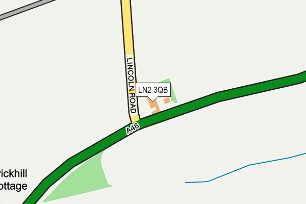
LN2 3QB is located in the Dunholme and Welton electoral ward, within the local authority district of West Lindsey and the English Parliamentary constituency of Gainsborough. The Sub Integrated Care Board (ICB) Location is NHS Lincolnshire ICB - 71E and the police force is Lincolnshire. This postcode has been in use since January 1980.


GetTheData
Source: OS OpenMap – Local (Ordnance Survey)
Source: OS VectorMap District (Ordnance Survey)
Licence: Open Government Licence (requires attribution)
| Easting | 500818 |
| Northing | 378159 |
| Latitude | 53.290815 |
| Longitude | -0.489002 |
GetTheData
Source: Open Postcode Geo
Licence: Open Government Licence
| Country | England |
| Postcode District | LN2 |
➜ See where LN2 is on a map | |
GetTheData
Source: Land Registry Price Paid Data
Licence: Open Government Licence
Elevation or altitude of LN2 3QB as distance above sea level:
| Metres | Feet | |
|---|---|---|
| Elevation | 30m | 98ft |
Elevation is measured from the approximate centre of the postcode, to the nearest point on an OS contour line from OS Terrain 50, which has contour spacing of ten vertical metres.
➜ How high above sea level am I? Find the elevation of your current position using your device's GPS.
GetTheData
Source: Open Postcode Elevation
Licence: Open Government Licence
| Ward | Dunholme And Welton |
| Constituency | Gainsborough |
GetTheData
Source: ONS Postcode Database
Licence: Open Government Licence
| Monckton Way (Lincoln Road) | Dunholme | 1,184m |
| Monckton Way (Lincoln Road) | Dunholme | 1,258m |
| William Farr School Bus Park (Lincoln Road) | Welton | 1,288m |
| William Farr School (Lincoln Road) | Welton | 1,329m |
| Kennington Close (Lincoln Road) | Dunholme | 1,334m |
GetTheData
Source: NaPTAN
Licence: Open Government Licence
GetTheData
Source: ONS Postcode Database
Licence: Open Government Licence


➜ Get more ratings from the Food Standards Agency
GetTheData
Source: Food Standards Agency
Licence: FSA terms & conditions
| Last Collection | |||
|---|---|---|---|
| Location | Mon-Fri | Sat | Distance |
| Honeyholes Lane | 17:00 | 11:00 | 1,588m |
| Welton Post Office | 17:00 | 11:45 | 1,771m |
| Dunholme | 17:15 | 12:15 | 1,856m |
GetTheData
Source: Dracos
Licence: Creative Commons Attribution-ShareAlike
The below table lists the International Territorial Level (ITL) codes (formerly Nomenclature of Territorial Units for Statistics (NUTS) codes) and Local Administrative Units (LAU) codes for LN2 3QB:
| ITL 1 Code | Name |
|---|---|
| TLF | East Midlands (England) |
| ITL 2 Code | Name |
| TLF3 | Lincolnshire |
| ITL 3 Code | Name |
| TLF30 | Lincolnshire CC |
| LAU 1 Code | Name |
| E07000142 | West Lindsey |
GetTheData
Source: ONS Postcode Directory
Licence: Open Government Licence
The below table lists the Census Output Area (OA), Lower Layer Super Output Area (LSOA), and Middle Layer Super Output Area (MSOA) for LN2 3QB:
| Code | Name | |
|---|---|---|
| OA | E00133969 | |
| LSOA | E01026372 | West Lindsey 008A |
| MSOA | E02005499 | West Lindsey 008 |
GetTheData
Source: ONS Postcode Directory
Licence: Open Government Licence
| LN2 3QD | Heath Road | 415m |
| LN2 3PZ | Lincoln Road | 749m |
| LN2 3SU | Honeyholes Lane | 1076m |
| LN2 3QL | Monckton Way | 1205m |
| LN2 3SS | Kneeland | 1313m |
| LN2 3SR | Anderson | 1340m |
| LN2 3JA | Lincoln Road | 1360m |
| LN2 3ST | Merleswen | 1374m |
| LN2 3UE | Pond Close | 1377m |
| LN2 3QY | Lincoln Road | 1412m |
GetTheData
Source: Open Postcode Geo; Land Registry Price Paid Data
Licence: Open Government Licence