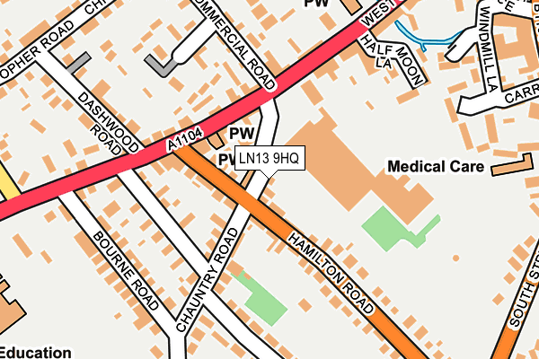
LN13 9HQ lies on Chauntry Road in Alford. LN13 9HQ is located in the Alford electoral ward, within the local authority district of East Lindsey and the English Parliamentary constituency of Louth and Horncastle. The Sub Integrated Care Board (ICB) Location is NHS Lincolnshire ICB - 71E and the police force is Lincolnshire. This postcode has been in use since January 1980.


GetTheData
Source: OS OpenMap – Local (Ordnance Survey)
Source: OS VectorMap District (Ordnance Survey)
Licence: Open Government Licence (requires attribution)
| Easting | 545217 |
| Northing | 375797 |
| Latitude | 53.259306 |
| Longitude | 0.175543 |
GetTheData
Source: Open Postcode Geo
Licence: Open Government Licence
| Street | Chauntry Road |
| Town/City | Alford |
| Country | England |
| Postcode District | LN13 |
➜ See where LN13 is on a map ➜ Where is Alford? | |
GetTheData
Source: Land Registry Price Paid Data
Licence: Open Government Licence
Elevation or altitude of LN13 9HQ as distance above sea level:
| Metres | Feet | |
|---|---|---|
| Elevation | 10m | 33ft |
Elevation is measured from the approximate centre of the postcode, to the nearest point on an OS contour line from OS Terrain 50, which has contour spacing of ten vertical metres.
➜ How high above sea level am I? Find the elevation of your current position using your device's GPS.
GetTheData
Source: Open Postcode Elevation
Licence: Open Government Licence
| Ward | Alford |
| Constituency | Louth And Horncastle |
GetTheData
Source: ONS Postcode Database
Licence: Open Government Licence
| 1 Hamilton Road (Hamilton Road) | Alford | 84m |
| 1 Hamilton Road (Hamilton Road) | Alford | 99m |
| Parsons Lane (Chauntry Road) | Alford | 134m |
| Parsons Lane (Chauntry Road) | Alford | 142m |
| 1 Bourne Road (Bourne Road) | Alford | 205m |
GetTheData
Source: NaPTAN
Licence: Open Government Licence
| Percentage of properties with Next Generation Access | 100.0% |
| Percentage of properties with Superfast Broadband | 100.0% |
| Percentage of properties with Ultrafast Broadband | 0.0% |
| Percentage of properties with Full Fibre Broadband | 0.0% |
Superfast Broadband is between 30Mbps and 300Mbps
Ultrafast Broadband is > 300Mbps
| Percentage of properties unable to receive 2Mbps | 0.0% |
| Percentage of properties unable to receive 5Mbps | 0.0% |
| Percentage of properties unable to receive 10Mbps | 0.0% |
| Percentage of properties unable to receive 30Mbps | 0.0% |
GetTheData
Source: Ofcom
Licence: Ofcom Terms of Use (requires attribution)
GetTheData
Source: ONS Postcode Database
Licence: Open Government Licence


➜ Get more ratings from the Food Standards Agency
GetTheData
Source: Food Standards Agency
Licence: FSA terms & conditions
| Last Collection | |||
|---|---|---|---|
| Location | Mon-Fri | Sat | Distance |
| Willoughby Post Office | 16:15 | 09:45 | 4,236m |
GetTheData
Source: Dracos
Licence: Creative Commons Attribution-ShareAlike
The below table lists the International Territorial Level (ITL) codes (formerly Nomenclature of Territorial Units for Statistics (NUTS) codes) and Local Administrative Units (LAU) codes for LN13 9HQ:
| ITL 1 Code | Name |
|---|---|
| TLF | East Midlands (England) |
| ITL 2 Code | Name |
| TLF3 | Lincolnshire |
| ITL 3 Code | Name |
| TLF30 | Lincolnshire CC |
| LAU 1 Code | Name |
| E07000137 | East Lindsey |
GetTheData
Source: ONS Postcode Directory
Licence: Open Government Licence
The below table lists the Census Output Area (OA), Lower Layer Super Output Area (LSOA), and Middle Layer Super Output Area (MSOA) for LN13 9HQ:
| Code | Name | |
|---|---|---|
| OA | E00132159 | |
| LSOA | E01026042 | East Lindsey 008A |
| MSOA | E02005431 | East Lindsey 008 |
GetTheData
Source: ONS Postcode Directory
Licence: Open Government Licence
| LN13 9HD | Hamilton Road | 66m |
| LN13 9HE | Hamilton Road | 66m |
| LN13 9HF | Hamilton Road | 68m |
| LN13 9EZ | West Street | 75m |
| LN13 9HG | Hamilton Road | 83m |
| LN13 9HH | Chauntry Road | 93m |
| LN13 9HA | West Street | 112m |
| LN13 9HB | West Street | 129m |
| LN13 9HR | Parsons Lane | 130m |
| LN13 9HS | Parsons Lane | 139m |
GetTheData
Source: Open Postcode Geo; Land Registry Price Paid Data
Licence: Open Government Licence