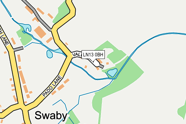
LN13 0BH lies on Valley Lane in Swaby, Alford. LN13 0BH is located in the Legbourne electoral ward, within the local authority district of East Lindsey and the English Parliamentary constituency of Louth and Horncastle. The Sub Integrated Care Board (ICB) Location is NHS Lincolnshire ICB - 71E and the police force is Lincolnshire. This postcode has been in use since January 1980.


GetTheData
Source: OS OpenMap – Local (Ordnance Survey)
Source: OS VectorMap District (Ordnance Survey)
Licence: Open Government Licence (requires attribution)
| Easting | 538918 |
| Northing | 377593 |
| Latitude | 53.277124 |
| Longitude | 0.081966 |
GetTheData
Source: Open Postcode Geo
Licence: Open Government Licence
| Street | Valley Lane |
| Locality | Swaby |
| Town/City | Alford |
| Country | England |
| Postcode District | LN13 |
➜ See where LN13 is on a map ➜ Where is Swaby? | |
GetTheData
Source: Land Registry Price Paid Data
Licence: Open Government Licence
Elevation or altitude of LN13 0BH as distance above sea level:
| Metres | Feet | |
|---|---|---|
| Elevation | 30m | 98ft |
Elevation is measured from the approximate centre of the postcode, to the nearest point on an OS contour line from OS Terrain 50, which has contour spacing of ten vertical metres.
➜ How high above sea level am I? Find the elevation of your current position using your device's GPS.
GetTheData
Source: Open Postcode Elevation
Licence: Open Government Licence
| Ward | Legbourne |
| Constituency | Louth And Horncastle |
GetTheData
Source: ONS Postcode Database
Licence: Open Government Licence
| Demand Responsive Area | Swaby | 122m |
| Padd Lane (North Lane) | Swaby | 262m |
| Padd Lane (North Lane) | Swaby | 276m |
| Church Lane (Whitepit Way) | Swaby | 949m |
| Church Lane (Whitepit Way) | Swaby | 966m |
GetTheData
Source: NaPTAN
Licence: Open Government Licence
| Percentage of properties with Next Generation Access | 100.0% |
| Percentage of properties with Superfast Broadband | 100.0% |
| Percentage of properties with Ultrafast Broadband | 0.0% |
| Percentage of properties with Full Fibre Broadband | 0.0% |
Superfast Broadband is between 30Mbps and 300Mbps
Ultrafast Broadband is > 300Mbps
| Median download speed | 64.3Mbps |
| Average download speed | 55.4Mbps |
| Maximum download speed | 80.00Mbps |
| Median upload speed | 16.4Mbps |
| Average upload speed | 13.0Mbps |
| Maximum upload speed | 20.00Mbps |
| Percentage of properties unable to receive 2Mbps | 0.0% |
| Percentage of properties unable to receive 5Mbps | 0.0% |
| Percentage of properties unable to receive 10Mbps | 0.0% |
| Percentage of properties unable to receive 30Mbps | 0.0% |
GetTheData
Source: Ofcom
Licence: Ofcom Terms of Use (requires attribution)
GetTheData
Source: ONS Postcode Database
Licence: Open Government Licence


➜ Get more ratings from the Food Standards Agency
GetTheData
Source: Food Standards Agency
Licence: FSA terms & conditions
The below table lists the International Territorial Level (ITL) codes (formerly Nomenclature of Territorial Units for Statistics (NUTS) codes) and Local Administrative Units (LAU) codes for LN13 0BH:
| ITL 1 Code | Name |
|---|---|
| TLF | East Midlands (England) |
| ITL 2 Code | Name |
| TLF3 | Lincolnshire |
| ITL 3 Code | Name |
| TLF30 | Lincolnshire CC |
| LAU 1 Code | Name |
| E07000137 | East Lindsey |
GetTheData
Source: ONS Postcode Directory
Licence: Open Government Licence
The below table lists the Census Output Area (OA), Lower Layer Super Output Area (LSOA), and Middle Layer Super Output Area (MSOA) for LN13 0BH:
| Code | Name | |
|---|---|---|
| OA | E00132294 | |
| LSOA | E01026068 | East Lindsey 009B |
| MSOA | E02005432 | East Lindsey 009 |
GetTheData
Source: ONS Postcode Directory
Licence: Open Government Licence
| LN13 0BU | Pado Lane | 162m |
| LN13 0BJ | Long Hedge Lane | 207m |
| LN13 0BE | Magdalen Close | 242m |
| LN13 0BB | Pinfold Lane | 327m |
| LN13 0BD | North Lane | 449m |
| LN13 0BL | 743m | |
| LN13 0BQ | Church Lane | 788m |
| LN13 0BX | Calceby Way | 984m |
| LN13 0AZ | Whitepit Way | 1053m |
| LN13 0BA | Mill Row | 1079m |
GetTheData
Source: Open Postcode Geo; Land Registry Price Paid Data
Licence: Open Government Licence