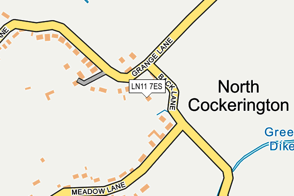
LN11 7ES lies on Back Lane in North Cockerington, Louth. LN11 7ES is located in the Grimoldby electoral ward, within the local authority district of East Lindsey and the English Parliamentary constituency of Louth and Horncastle. The Sub Integrated Care Board (ICB) Location is NHS Lincolnshire ICB - 71E and the police force is Lincolnshire. This postcode has been in use since January 1980.


GetTheData
Source: OS OpenMap – Local (Ordnance Survey)
Source: OS VectorMap District (Ordnance Survey)
Licence: Open Government Licence (requires attribution)
| Easting | 537431 |
| Northing | 390809 |
| Latitude | 53.396229 |
| Longitude | 0.065409 |
GetTheData
Source: Open Postcode Geo
Licence: Open Government Licence
| Street | Back Lane |
| Locality | North Cockerington |
| Town/City | Louth |
| Country | England |
| Postcode District | LN11 |
➜ See where LN11 is on a map ➜ Where is North Cockerington? | |
GetTheData
Source: Land Registry Price Paid Data
Licence: Open Government Licence
Elevation or altitude of LN11 7ES as distance above sea level:
| Metres | Feet | |
|---|---|---|
| Elevation | 10m | 33ft |
Elevation is measured from the approximate centre of the postcode, to the nearest point on an OS contour line from OS Terrain 50, which has contour spacing of ten vertical metres.
➜ How high above sea level am I? Find the elevation of your current position using your device's GPS.
GetTheData
Source: Open Postcode Elevation
Licence: Open Government Licence
| Ward | Grimoldby |
| Constituency | Louth And Horncastle |
GetTheData
Source: ONS Postcode Database
Licence: Open Government Licence
| Primary School (School Lane) | North Cockerington | 455m |
| Demand Responsive Area | North Cockerington | 462m |
| Primary School (School Lane) | North Cockerington | 468m |
| Red Leas Lane (Mill Hill Way) | South Cockerington | 1,193m |
| Red Leas Lane (Mill Hill Way) | South Cockerington | 1,213m |
GetTheData
Source: NaPTAN
Licence: Open Government Licence
| Percentage of properties with Next Generation Access | 100.0% |
| Percentage of properties with Superfast Broadband | 100.0% |
| Percentage of properties with Ultrafast Broadband | 0.0% |
| Percentage of properties with Full Fibre Broadband | 0.0% |
Superfast Broadband is between 30Mbps and 300Mbps
Ultrafast Broadband is > 300Mbps
| Percentage of properties unable to receive 2Mbps | 0.0% |
| Percentage of properties unable to receive 5Mbps | 0.0% |
| Percentage of properties unable to receive 10Mbps | 0.0% |
| Percentage of properties unable to receive 30Mbps | 0.0% |
GetTheData
Source: Ofcom
Licence: Ofcom Terms of Use (requires attribution)
GetTheData
Source: ONS Postcode Database
Licence: Open Government Licence

➜ Get more ratings from the Food Standards Agency
GetTheData
Source: Food Standards Agency
Licence: FSA terms & conditions
| Last Collection | |||
|---|---|---|---|
| Location | Mon-Fri | Sat | Distance |
| Yrborough | 16:45 | 11:00 | 3,250m |
| Keddington | 17:00 | 07:00 | 3,666m |
| Austen Fen | 16:30 | 10:15 | 3,848m |
GetTheData
Source: Dracos
Licence: Creative Commons Attribution-ShareAlike
The below table lists the International Territorial Level (ITL) codes (formerly Nomenclature of Territorial Units for Statistics (NUTS) codes) and Local Administrative Units (LAU) codes for LN11 7ES:
| ITL 1 Code | Name |
|---|---|
| TLF | East Midlands (England) |
| ITL 2 Code | Name |
| TLF3 | Lincolnshire |
| ITL 3 Code | Name |
| TLF30 | Lincolnshire CC |
| LAU 1 Code | Name |
| E07000137 | East Lindsey |
GetTheData
Source: ONS Postcode Directory
Licence: Open Government Licence
The below table lists the Census Output Area (OA), Lower Layer Super Output Area (LSOA), and Middle Layer Super Output Area (MSOA) for LN11 7ES:
| Code | Name | |
|---|---|---|
| OA | E00132240 | |
| LSOA | E01026058 | East Lindsey 002A |
| MSOA | E02005425 | East Lindsey 002 |
GetTheData
Source: ONS Postcode Directory
Licence: Open Government Licence
| LN11 7ER | Meadow Lane | 184m |
| LN11 7ET | Chapel Lane | 253m |
| LN11 7EW | Back Lane | 354m |
| LN11 7EP | School Lane | 603m |
| LN11 7EU | Lock Road | 1011m |
| LN11 0QD | Church Lane | 1021m |
| LN11 0PY | Church Lane | 1151m |
| LN11 0PZ | 1226m | |
| LN11 0QB | High Bridge Road | 1240m |
| LN11 0QF | High Bridge Road | 1294m |
GetTheData
Source: Open Postcode Geo; Land Registry Price Paid Data
Licence: Open Government Licence