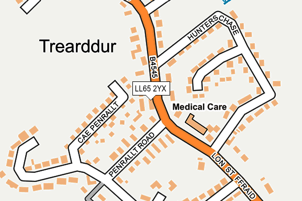
LL65 2YX lies on Lon Tesog in Trearddur Bay, Holyhead. LL65 2YX is located in the Ynys Gybi electoral ward, within the unitary authority of Isle of Anglesey and the Welsh Parliamentary constituency of Ynys Môn. The Local Health Board is Betsi Cadwaladr University and the police force is North Wales. This postcode has been in use since September 2006.


GetTheData
Source: OS OpenMap – Local (Ordnance Survey)
Source: OS VectorMap District (Ordnance Survey)
Licence: Open Government Licence (requires attribution)
| Easting | 225326 |
| Northing | 379802 |
| Latitude | 53.286324 |
| Longitude | -4.621797 |
GetTheData
Source: Open Postcode Geo
Licence: Open Government Licence
| Street | Lon Tesog |
| Locality | Trearddur Bay |
| Town/City | Holyhead |
| Country | Wales |
| Postcode District | LL65 |
➜ See where LL65 is on a map ➜ Where is Trearddur? | |
GetTheData
Source: Land Registry Price Paid Data
Licence: Open Government Licence
Elevation or altitude of LL65 2YX as distance above sea level:
| Metres | Feet | |
|---|---|---|
| Elevation | 20m | 66ft |
Elevation is measured from the approximate centre of the postcode, to the nearest point on an OS contour line from OS Terrain 50, which has contour spacing of ten vertical metres.
➜ How high above sea level am I? Find the elevation of your current position using your device's GPS.
GetTheData
Source: Open Postcode Elevation
Licence: Open Government Licence
| Ward | Ynys Gybi |
| Constituency | Ynys Môn |
GetTheData
Source: ONS Postcode Database
Licence: Open Government Licence
2022 10 JUN £462,500 |
2019 19 DEC £237,500 |
2019 21 JUN £240,000 |
7, LON TESOG, TREARDDUR BAY, HOLYHEAD, LL65 2YX 2017 24 FEB £265,000 |
2016 15 MAR £227,500 |
2014 2 JUL £240,000 |
2010 20 OCT £245,000 |
2010 22 MAR £250,000 |
2009 31 JUL £224,950 |
2007 4 OCT £249,950 |
GetTheData
Source: HM Land Registry Price Paid Data
Licence: Contains HM Land Registry data © Crown copyright and database right 2025. This data is licensed under the Open Government Licence v3.0.
| Hunters Chase (Lon St Ffraid) | Trearddur | 84m |
| Penrallt Road (Lon St Ffraid) | Trearddur | 84m |
| Penrhyngeiriol (Lon St Ffraid) | Trearddur | 300m |
| Penrhyngeiriol (Lon St Ffraid) | Trearddur | 338m |
| Square (Lon St Ffraid) | Trearddur | 576m |
| Holyhead Station | 2.5km |
| Valley Station | 3.9km |
GetTheData
Source: NaPTAN
Licence: Open Government Licence
| Percentage of properties with Next Generation Access | 100.0% |
| Percentage of properties with Superfast Broadband | 100.0% |
| Percentage of properties with Ultrafast Broadband | 0.0% |
| Percentage of properties with Full Fibre Broadband | 0.0% |
Superfast Broadband is between 30Mbps and 300Mbps
Ultrafast Broadband is > 300Mbps
| Median download speed | 20.8Mbps |
| Average download speed | 40.8Mbps |
| Maximum download speed | 80.00Mbps |
| Median upload speed | 1.1Mbps |
| Average upload speed | 8.6Mbps |
| Maximum upload speed | 20.00Mbps |
| Percentage of properties unable to receive 2Mbps | 0.0% |
| Percentage of properties unable to receive 5Mbps | 0.0% |
| Percentage of properties unable to receive 10Mbps | 0.0% |
| Percentage of properties unable to receive 30Mbps | 0.0% |
GetTheData
Source: Ofcom
Licence: Ofcom Terms of Use (requires attribution)
Estimated total energy consumption in LL65 2YX by fuel type, 2015.
| Consumption (kWh) | 65,053 |
|---|---|
| Meter count | 6 |
| Mean (kWh/meter) | 10,842 |
| Median (kWh/meter) | 9,512 |
GetTheData
Source: Postcode level gas estimates: 2015 (experimental)
Source: Postcode level electricity estimates: 2015 (experimental)
Licence: Open Government Licence
GetTheData
Source: ONS Postcode Database
Licence: Open Government Licence


➜ Get more ratings from the Food Standards Agency
GetTheData
Source: Food Standards Agency
Licence: FSA terms & conditions
| Last Collection | |||
|---|---|---|---|
| Location | Mon-Fri | Sat | Distance |
| Morrison's | 17:30 | 12:30 | 211m |
| Market Street | 17:00 | 11:45 | 1,384m |
| Gors | 16:00 | 11:45 | 3,145m |
GetTheData
Source: Dracos
Licence: Creative Commons Attribution-ShareAlike
The below table lists the International Territorial Level (ITL) codes (formerly Nomenclature of Territorial Units for Statistics (NUTS) codes) and Local Administrative Units (LAU) codes for LL65 2YX:
| ITL 1 Code | Name |
|---|---|
| TLL | Wales |
| ITL 2 Code | Name |
| TLL1 | West Wales and The Valleys |
| ITL 3 Code | Name |
| TLL11 | Isle of Anglesey |
| LAU 1 Code | Name |
| W06000001 | Isle of Anglesey |
GetTheData
Source: ONS Postcode Directory
Licence: Open Government Licence
The below table lists the Census Output Area (OA), Lower Layer Super Output Area (LSOA), and Middle Layer Super Output Area (MSOA) for LL65 2YX:
| Code | Name | |
|---|---|---|
| OA | W00000202 | |
| LSOA | W01000040 | Isle of Anglesey 004D |
| MSOA | W02000004 | Isle of Anglesey 004 |
GetTheData
Source: ONS Postcode Directory
Licence: Open Government Licence
| LL65 2WA | Cae Penrallt | 106m |
| LL65 2LX | Hunters Chase | 170m |
| LL65 2UG | Penrallt Road | 175m |
| LL65 2UF | Snowdon View Road | 198m |
| LL65 2YH | Lon St Ffraid | 234m |
| LL65 2YW | Penrhyn Geiriol | 293m |
| LL65 2UY | The Rise | 319m |
| LL65 2UD | Lon St Ffraid | 360m |
| LL65 2YL | Lon Garreg Fawr | 391m |
| LL65 2TW | Trearddur Court | 432m |
GetTheData
Source: Open Postcode Geo; Land Registry Price Paid Data
Licence: Open Government Licence