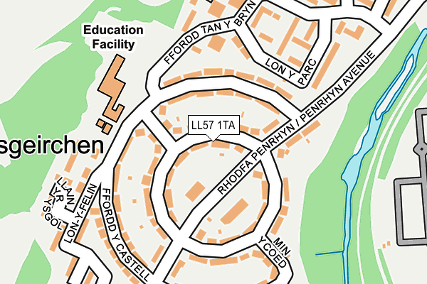
LL57 1TA lies on Kingsley Avenue in Bangor. LL57 1TA is located in the Dwyrain Bangor electoral ward, within the unitary authority of Gwynedd and the Welsh Parliamentary constituency of Arfon. The Local Health Board is Betsi Cadwaladr University and the police force is North Wales. This postcode has been in use since January 1980.


GetTheData
Source: OS OpenMap – Local (Ordnance Survey)
Source: OS VectorMap District (Ordnance Survey)
Licence: Open Government Licence (requires attribution)
| Easting | 258892 |
| Northing | 371894 |
| Latitude | 53.225294 |
| Longitude | -4.115176 |
GetTheData
Source: Open Postcode Geo
Licence: Open Government Licence
| Street | Kingsley Avenue |
| Town/City | Bangor |
| Country | Wales |
| Postcode District | LL57 |
➜ See where LL57 is on a map ➜ Where is Bangor? | |
GetTheData
Source: Land Registry Price Paid Data
Licence: Open Government Licence
Elevation or altitude of LL57 1TA as distance above sea level:
| Metres | Feet | |
|---|---|---|
| Elevation | 40m | 131ft |
Elevation is measured from the approximate centre of the postcode, to the nearest point on an OS contour line from OS Terrain 50, which has contour spacing of ten vertical metres.
➜ How high above sea level am I? Find the elevation of your current position using your device's GPS.
GetTheData
Source: Open Postcode Elevation
Licence: Open Government Licence
| Ward | Dwyrain Bangor |
| Constituency | Arfon |
GetTheData
Source: ONS Postcode Database
Licence: Open Government Licence
| Maesgeirchen Circle East (Penrhyn Avenue) | Maesgeirchen | 50m |
| Ysgol Glancegin (Ffordd Y Castell) | Bangor | 108m |
| Maesgeirchen Circle West (Penrhyn Avenue) | Maesgeirchen | 126m |
| Lon-y-felin (Ffordd Castell) | Bangor | 163m |
| Min-y-coed | Maesgeirchen | 168m |
| Bangor (Gwynedd) Station | 1.4km |
GetTheData
Source: NaPTAN
Licence: Open Government Licence
| Percentage of properties with Next Generation Access | 100.0% |
| Percentage of properties with Superfast Broadband | 100.0% |
| Percentage of properties with Ultrafast Broadband | 0.0% |
| Percentage of properties with Full Fibre Broadband | 0.0% |
Superfast Broadband is between 30Mbps and 300Mbps
Ultrafast Broadband is > 300Mbps
| Median download speed | 40.0Mbps |
| Average download speed | 34.4Mbps |
| Maximum download speed | 55.00Mbps |
| Median upload speed | 10.0Mbps |
| Average upload speed | 9.8Mbps |
| Maximum upload speed | 20.00Mbps |
| Percentage of properties unable to receive 2Mbps | 0.0% |
| Percentage of properties unable to receive 5Mbps | 0.0% |
| Percentage of properties unable to receive 10Mbps | 0.0% |
| Percentage of properties unable to receive 30Mbps | 0.0% |
GetTheData
Source: Ofcom
Licence: Ofcom Terms of Use (requires attribution)
Estimated total energy consumption in LL57 1TA by fuel type, 2015.
| Consumption (kWh) | 307,802 |
|---|---|
| Meter count | 31 |
| Mean (kWh/meter) | 9,929 |
| Median (kWh/meter) | 10,457 |
| Consumption (kWh) | 99,568 |
|---|---|
| Meter count | 28 |
| Mean (kWh/meter) | 3,556 |
| Median (kWh/meter) | 3,713 |
GetTheData
Source: Postcode level gas estimates: 2015 (experimental)
Source: Postcode level electricity estimates: 2015 (experimental)
Licence: Open Government Licence
GetTheData
Source: ONS Postcode Database
Licence: Open Government Licence


➜ Get more ratings from the Food Standards Agency
GetTheData
Source: Food Standards Agency
Licence: FSA terms & conditions
| Last Collection | |||
|---|---|---|---|
| Location | Mon-Fri | Sat | Distance |
| Por Penrhyn | 17:15 | 11:00 | 622m |
| Woolworths | 17:30 | 11:15 | 672m |
| Beach Road | 17:30 | 11:07 | 739m |
GetTheData
Source: Dracos
Licence: Creative Commons Attribution-ShareAlike
The below table lists the International Territorial Level (ITL) codes (formerly Nomenclature of Territorial Units for Statistics (NUTS) codes) and Local Administrative Units (LAU) codes for LL57 1TA:
| ITL 1 Code | Name |
|---|---|
| TLL | Wales |
| ITL 2 Code | Name |
| TLL1 | West Wales and The Valleys |
| ITL 3 Code | Name |
| TLL12 | Gwynedd |
| LAU 1 Code | Name |
| W06000002 | Gwynedd |
GetTheData
Source: ONS Postcode Directory
Licence: Open Government Licence
The below table lists the Census Output Area (OA), Lower Layer Super Output Area (LSOA), and Middle Layer Super Output Area (MSOA) for LL57 1TA:
| Code | Name | |
|---|---|---|
| OA | W00000465 | |
| LSOA | W01000091 | Gwynedd 001D |
| MSOA | W02000010 | Gwynedd 001 |
GetTheData
Source: ONS Postcode Directory
Licence: Open Government Licence
| LL57 1SY | Tan Y Mynydd | 69m |
| LL57 1SU | Ffordd Y Castell | 73m |
| LL57 1TB | Kingsley Avenue | 96m |
| LL57 1LR | Penrhyn Avenue | 104m |
| LL57 1SN | Llys Mabon | 131m |
| LL57 1TH | Greenwood Avenue | 133m |
| LL57 1TD | Ffordd Y Castell | 171m |
| LL57 1SH | Llys Owain | 173m |
| LL57 1SS | Lon Y Parc | 174m |
| LL57 1TG | Min Y Coed | 181m |
GetTheData
Source: Open Postcode Geo; Land Registry Price Paid Data
Licence: Open Government Licence