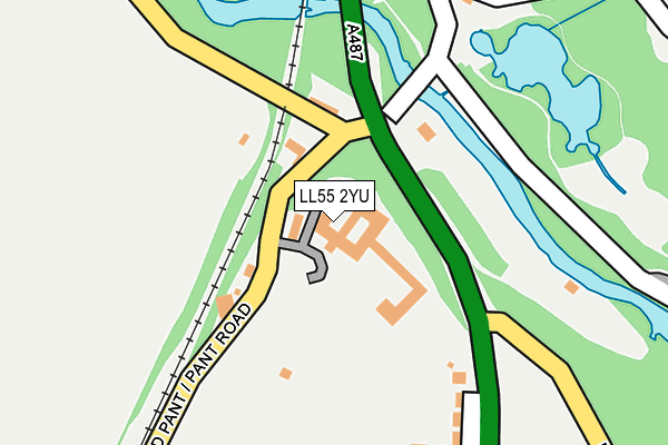
LL55 2YU is located in the Canol Tref Caernarfon electoral ward, within the unitary authority of Gwynedd and the Welsh Parliamentary constituency of Arfon. The Local Health Board is Betsi Cadwaladr University and the police force is North Wales. This postcode has been in use since August 2015.


GetTheData
Source: OS OpenMap – Local (Ordnance Survey)
Source: OS VectorMap District (Ordnance Survey)
Licence: Open Government Licence (requires attribution)
| Easting | 248223 |
| Northing | 361501 |
| Latitude | 53.129021 |
| Longitude | -4.269929 |
GetTheData
Source: Open Postcode Geo
Licence: Open Government Licence
| Country | Wales |
| Postcode District | LL55 |
➜ See where LL55 is on a map ➜ Where is Caernarfon? | |
GetTheData
Source: Land Registry Price Paid Data
Licence: Open Government Licence
Elevation or altitude of LL55 2YU as distance above sea level:
| Metres | Feet | |
|---|---|---|
| Elevation | 20m | 66ft |
Elevation is measured from the approximate centre of the postcode, to the nearest point on an OS contour line from OS Terrain 50, which has contour spacing of ten vertical metres.
➜ How high above sea level am I? Find the elevation of your current position using your device's GPS.
GetTheData
Source: Open Postcode Elevation
Licence: Open Government Licence
| Ward | Canol Tref Caernarfon |
| Constituency | Arfon |
GetTheData
Source: ONS Postcode Database
Licence: Open Government Licence
| Bryn Seiont (Pant Road) | Caernarfon | 140m |
| Bryn Seiont (Pant Road) | Caernarfon | 149m |
| Parc Muriau (Pwllheli Road) | Caernarfon | 176m |
| Parc Muriau (Pwllheli Road) | Caernarfon | 212m |
| Tesco (South Road) | Caernarfon | 332m |
| Caernarfon (Welsh Highland Rly-caernarfon) | Caernarfon | 948m |
GetTheData
Source: NaPTAN
Licence: Open Government Licence
GetTheData
Source: ONS Postcode Database
Licence: Open Government Licence


➜ Get more ratings from the Food Standards Agency
GetTheData
Source: Food Standards Agency
Licence: FSA terms & conditions
| Last Collection | |||
|---|---|---|---|
| Location | Mon-Fri | Sat | Distance |
| Y Maes Box | 17:30 | 12:30 | 1,167m |
| Y Maes | 17:30 | 12:30 | 1,167m |
| Caernarfon Delivery Office | 17:30 | 13:00 | 1,538m |
GetTheData
Source: Dracos
Licence: Creative Commons Attribution-ShareAlike
The below table lists the International Territorial Level (ITL) codes (formerly Nomenclature of Territorial Units for Statistics (NUTS) codes) and Local Administrative Units (LAU) codes for LL55 2YU:
| ITL 1 Code | Name |
|---|---|
| TLL | Wales |
| ITL 2 Code | Name |
| TLL1 | West Wales and The Valleys |
| ITL 3 Code | Name |
| TLL12 | Gwynedd |
| LAU 1 Code | Name |
| W06000002 | Gwynedd |
GetTheData
Source: ONS Postcode Directory
Licence: Open Government Licence
The below table lists the Census Output Area (OA), Lower Layer Super Output Area (LSOA), and Middle Layer Super Output Area (MSOA) for LL55 2YU:
| Code | Name | |
|---|---|---|
| OA | W00000575 | |
| LSOA | W01000111 | Gwynedd 007C |
| MSOA | W02000016 | Gwynedd 007 |
GetTheData
Source: ONS Postcode Directory
Licence: Open Government Licence
| LL55 2YR | Muriau Park | 222m |
| LL55 2YT | Pen Y Bryn | 395m |
| LL55 2YL | Seiont Mill Road | 427m |
| LL55 2UT | Llys Y Garn | 439m |
| LL55 2US | Ffordd Eryri | 448m |
| LL55 2LQ | Cae Corn Hir | 467m |
| LL55 2YS | Pwllheli Road | 479m |
| LL55 2LJ | Llys Yr Eifl | 504m |
| LL55 2HS | South Road | 529m |
| LL55 2UP | Lon Oleuwen | 537m |
GetTheData
Source: Open Postcode Geo; Land Registry Price Paid Data
Licence: Open Government Licence