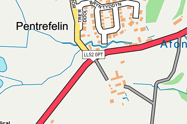
LL52 0PT is in Pentrefelin, Criccieth. LL52 0PT is located in the Dolbenmaen electoral ward, within the unitary authority of Gwynedd and the Welsh Parliamentary constituency of Dwyfor Meirionnydd. The Local Health Board is Betsi Cadwaladr University and the police force is North Wales. This postcode has been in use since January 1980.


GetTheData
Source: OS OpenMap – Local (Ordnance Survey)
Source: OS VectorMap District (Ordnance Survey)
Licence: Open Government Licence (requires attribution)
| Easting | 252339 |
| Northing | 339573 |
| Latitude | 52.933192 |
| Longitude | -4.198410 |
GetTheData
Source: Open Postcode Geo
Licence: Open Government Licence
| Locality | Pentrefelin |
| Town/City | Criccieth |
| Country | Wales |
| Postcode District | LL52 |
➜ See where LL52 is on a map ➜ Where is Pentrefelin? | |
GetTheData
Source: Land Registry Price Paid Data
Licence: Open Government Licence
Elevation or altitude of LL52 0PT as distance above sea level:
| Metres | Feet | |
|---|---|---|
| Elevation | 30m | 98ft |
Elevation is measured from the approximate centre of the postcode, to the nearest point on an OS contour line from OS Terrain 50, which has contour spacing of ten vertical metres.
➜ How high above sea level am I? Find the elevation of your current position using your device's GPS.
GetTheData
Source: Open Postcode Elevation
Licence: Open Government Licence
| Ward | Dolbenmaen |
| Constituency | Dwyfor Meirionnydd |
GetTheData
Source: ONS Postcode Database
Licence: Open Government Licence
TYNDWR, PENTREFELIN, CRICCIETH, LL52 0PT 2023 15 DEC £152,500 |
2023 25 APR £175,000 |
TANYGRAIG, PENTREFELIN, CRICCIETH, LL52 0PT 2019 18 APR £442,000 |
2018 2 NOV £180,000 |
BRON HEULOG, PENTREFELIN, CRICCIETH, LL52 0PT 2016 14 DEC £162,500 |
TYNYRARDD, PENTREFELIN, CRICCIETH, LL52 0PT 2016 18 NOV £110,000 |
HAFAN, PENTREFELIN, CRICCIETH, LL52 0PT 2016 15 NOV £155,000 |
2016 26 FEB £157,000 |
BRYN HYFRYD, PENTREFELIN, CRICCIETH, LL52 0PT 2011 29 JUL £110,000 |
COED ESTYN, PENTREFELIN, CRICCIETH, LL52 0PT 2010 5 MAY £307,500 |
GetTheData
Source: HM Land Registry Price Paid Data
Licence: Contains HM Land Registry data © Crown copyright and database right 2025. This data is licensed under the Open Government Licence v3.0.
| Yr Hen Efail (A497) | Pentrefelin | 104m |
| Yr Hen Efail (A497) | Pentrefelin | 143m |
| Plasgwyn (A497) | Pentrefelin | 442m |
| Plasgwyn (A497) | Pentrefelin | 454m |
| Swyddfa'r Post Office (A497) | Pentrefelin | 464m |
| Criccieth Station | 3.1km |
| Porthmadog Station | 4.3km |
| Porthmadog Harbour Ffestiniog Railway Station | 4.9km |
GetTheData
Source: NaPTAN
Licence: Open Government Licence
| Percentage of properties with Next Generation Access | 100.0% |
| Percentage of properties with Superfast Broadband | 100.0% |
| Percentage of properties with Ultrafast Broadband | 3.0% |
| Percentage of properties with Full Fibre Broadband | 3.0% |
Superfast Broadband is between 30Mbps and 300Mbps
Ultrafast Broadband is > 300Mbps
| Median download speed | 40.0Mbps |
| Average download speed | 37.9Mbps |
| Maximum download speed | 79.29Mbps |
| Median upload speed | 10.0Mbps |
| Average upload speed | 9.1Mbps |
| Maximum upload speed | 20.00Mbps |
| Percentage of properties unable to receive 2Mbps | 0.0% |
| Percentage of properties unable to receive 5Mbps | 0.0% |
| Percentage of properties unable to receive 10Mbps | 0.0% |
| Percentage of properties unable to receive 30Mbps | 0.0% |
GetTheData
Source: Ofcom
Licence: Ofcom Terms of Use (requires attribution)
Estimated total energy consumption in LL52 0PT by fuel type, 2015.
| Consumption (kWh) | 312,653 |
|---|---|
| Meter count | 24 |
| Mean (kWh/meter) | 13,027 |
| Median (kWh/meter) | 9,676 |
| Consumption (kWh) | 131,321 |
|---|---|
| Meter count | 35 |
| Mean (kWh/meter) | 3,752 |
| Median (kWh/meter) | 2,892 |
GetTheData
Source: Postcode level gas estimates: 2015 (experimental)
Source: Postcode level electricity estimates: 2015 (experimental)
Licence: Open Government Licence
GetTheData
Source: ONS Postcode Database
Licence: Open Government Licence

➜ Get more ratings from the Food Standards Agency
GetTheData
Source: Food Standards Agency
Licence: FSA terms & conditions
| Last Collection | |||
|---|---|---|---|
| Location | Mon-Fri | Sat | Distance |
| Castle Street | 16:33 | 11:30 | 2,820m |
| Morfa Bychan Post Office | 16:30 | 10:00 | 3,193m |
| Tremadog Post Office | 16:15 | 11:00 | 3,889m |
GetTheData
Source: Dracos
Licence: Creative Commons Attribution-ShareAlike
The below table lists the International Territorial Level (ITL) codes (formerly Nomenclature of Territorial Units for Statistics (NUTS) codes) and Local Administrative Units (LAU) codes for LL52 0PT:
| ITL 1 Code | Name |
|---|---|
| TLL | Wales |
| ITL 2 Code | Name |
| TLL1 | West Wales and The Valleys |
| ITL 3 Code | Name |
| TLL12 | Gwynedd |
| LAU 1 Code | Name |
| W06000002 | Gwynedd |
GetTheData
Source: ONS Postcode Directory
Licence: Open Government Licence
The below table lists the Census Output Area (OA), Lower Layer Super Output Area (LSOA), and Middle Layer Super Output Area (MSOA) for LL52 0PT:
| Code | Name | |
|---|---|---|
| OA | W00000340 | |
| LSOA | W01000066 | Gwynedd 010A |
| MSOA | W02000019 | Gwynedd 010 |
GetTheData
Source: ONS Postcode Directory
Licence: Open Government Licence
| LL52 0RA | 147m | |
| LL52 0PE | Bryn Tyddyn | 152m |
| LL52 0PY | 462m | |
| LL52 0PU | 496m | |
| LL52 0RB | 647m | |
| LL52 0PS | Portmadoc Road | 1494m |
| LL52 0RD | 1573m | |
| LL49 9SH | 1667m | |
| LL52 0RE | 1710m | |
| LL49 9YN | 1860m |
GetTheData
Source: Open Postcode Geo; Land Registry Price Paid Data
Licence: Open Government Licence