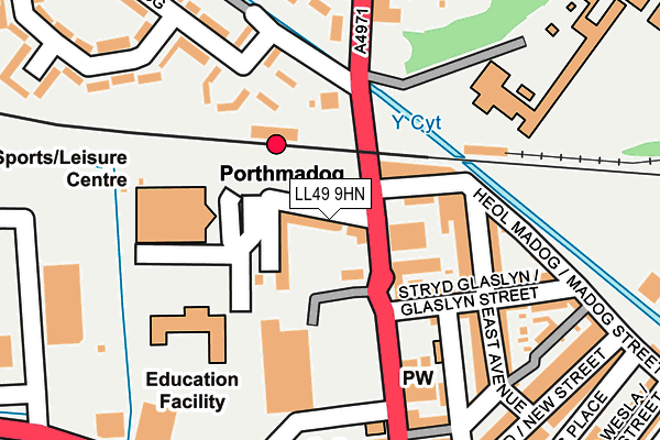
LL49 9HN lies on Railway Place in Porthmadog. LL49 9HN is located in the Gorllewin Porthmadog electoral ward, within the unitary authority of Gwynedd and the Welsh Parliamentary constituency of Dwyfor Meirionnydd. The Local Health Board is Betsi Cadwaladr University and the police force is North Wales. This postcode has been in use since January 1980.


GetTheData
Source: OS OpenMap – Local (Ordnance Survey)
Source: OS VectorMap District (Ordnance Survey)
Licence: Open Government Licence (requires attribution)
| Easting | 256614 |
| Northing | 339122 |
| Latitude | 52.930300 |
| Longitude | -4.134654 |
GetTheData
Source: Open Postcode Geo
Licence: Open Government Licence
| Street | Railway Place |
| Town/City | Porthmadog |
| Country | Wales |
| Postcode District | LL49 |
➜ See where LL49 is on a map ➜ Where is Porthmadog? | |
GetTheData
Source: Land Registry Price Paid Data
Licence: Open Government Licence
Elevation or altitude of LL49 9HN as distance above sea level:
| Metres | Feet | |
|---|---|---|
| Elevation | 10m | 33ft |
Elevation is measured from the approximate centre of the postcode, to the nearest point on an OS contour line from OS Terrain 50, which has contour spacing of ten vertical metres.
➜ How high above sea level am I? Find the elevation of your current position using your device's GPS.
GetTheData
Source: Open Postcode Elevation
Licence: Open Government Licence
| Ward | Gorllewin Porthmadog |
| Constituency | Dwyfor Meirionnydd |
GetTheData
Source: ONS Postcode Database
Licence: Open Government Licence
| Station (High Street) | Porthmadog | 64m |
| Rhes Cambrian (High Street) | Porthmadog | 66m |
| Tesco (High Street) | Porthmadog | 143m |
| War Memorial (High Street) | Porthmadog | 188m |
| Sportsman (High Street) | Porthmadog | 222m |
| Porthmadog Station | 0.1km |
| Porthmadog Harbour Ffestiniog Railway Station | 0.9km |
| Minffordd Station | 3.4km |
GetTheData
Source: NaPTAN
Licence: Open Government Licence
| Percentage of properties with Next Generation Access | 100.0% |
| Percentage of properties with Superfast Broadband | 100.0% |
| Percentage of properties with Ultrafast Broadband | 0.0% |
| Percentage of properties with Full Fibre Broadband | 0.0% |
Superfast Broadband is between 30Mbps and 300Mbps
Ultrafast Broadband is > 300Mbps
| Median download speed | 78.6Mbps |
| Average download speed | 58.6Mbps |
| Maximum download speed | 80.00Mbps |
| Median upload speed | 17.2Mbps |
| Average upload speed | 13.7Mbps |
| Maximum upload speed | 20.00Mbps |
| Percentage of properties unable to receive 2Mbps | 0.0% |
| Percentage of properties unable to receive 5Mbps | 0.0% |
| Percentage of properties unable to receive 10Mbps | 0.0% |
| Percentage of properties unable to receive 30Mbps | 0.0% |
GetTheData
Source: Ofcom
Licence: Ofcom Terms of Use (requires attribution)
Estimated total energy consumption in LL49 9HN by fuel type, 2015.
| Consumption (kWh) | 148,163 |
|---|---|
| Meter count | 18 |
| Mean (kWh/meter) | 8,231 |
| Median (kWh/meter) | 6,093 |
| Consumption (kWh) | 34,573 |
|---|---|
| Meter count | 15 |
| Mean (kWh/meter) | 2,305 |
| Median (kWh/meter) | 1,749 |
GetTheData
Source: Postcode level gas estimates: 2015 (experimental)
Source: Postcode level electricity estimates: 2015 (experimental)
Licence: Open Government Licence
GetTheData
Source: ONS Postcode Database
Licence: Open Government Licence


➜ Get more ratings from the Food Standards Agency
GetTheData
Source: Food Standards Agency
Licence: FSA terms & conditions
| Last Collection | |||
|---|---|---|---|
| Location | Mon-Fri | Sat | Distance |
| High Street | 17:00 | 11:30 | 239m |
| Porthmadog Post Office | 17:30 | 12:15 | 513m |
| Ynys Towyn | 15:30 | 11:39 | 814m |
GetTheData
Source: Dracos
Licence: Creative Commons Attribution-ShareAlike
The below table lists the International Territorial Level (ITL) codes (formerly Nomenclature of Territorial Units for Statistics (NUTS) codes) and Local Administrative Units (LAU) codes for LL49 9HN:
| ITL 1 Code | Name |
|---|---|
| TLL | Wales |
| ITL 2 Code | Name |
| TLL1 | West Wales and The Valleys |
| ITL 3 Code | Name |
| TLL12 | Gwynedd |
| LAU 1 Code | Name |
| W06000002 | Gwynedd |
GetTheData
Source: ONS Postcode Directory
Licence: Open Government Licence
The below table lists the Census Output Area (OA), Lower Layer Super Output Area (LSOA), and Middle Layer Super Output Area (MSOA) for LL49 9HN:
| Code | Name | |
|---|---|---|
| OA | W00000544 | |
| LSOA | W01000106 | Gwynedd 010D |
| MSOA | W02000019 | Gwynedd 010 |
GetTheData
Source: ONS Postcode Directory
Licence: Open Government Licence
| LL49 9HW | Church Street | 50m |
| LL49 9EH | Cambrian Terrace | 86m |
| LL49 9EL | East Avenue | 129m |
| LL49 9LA | Pensyflog | 171m |
| LL49 9HD | High Street | 175m |
| LL49 9EN | East Avenue | 182m |
| LL49 9EG | Glaslyn Street | 190m |
| LL49 9EQ | 191m | |
| LL49 9HT | 204m | |
| LL49 9EW | Hughendon Cottages | 209m |
GetTheData
Source: Open Postcode Geo; Land Registry Price Paid Data
Licence: Open Government Licence