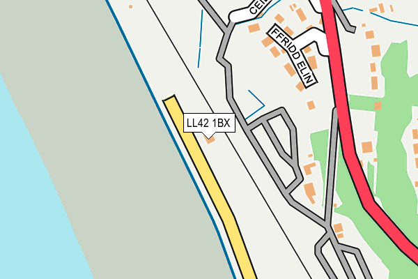
LL42 1BX lies on The Promenade in Barmouth. LL42 1BX is located in the Abermaw electoral ward, within the unitary authority of Gwynedd and the Welsh Parliamentary constituency of Dwyfor Meirionnydd. The Local Health Board is Betsi Cadwaladr University and the police force is North Wales. This postcode has been in use since January 1980.


GetTheData
Source: OS OpenMap – Local (Ordnance Survey)
Source: OS VectorMap District (Ordnance Survey)
Licence: Open Government Licence (requires attribution)
| Easting | 260409 |
| Northing | 317006 |
| Latitude | 52.732637 |
| Longitude | -4.068778 |
GetTheData
Source: Open Postcode Geo
Licence: Open Government Licence
| Street | The Promenade |
| Town/City | Barmouth |
| Country | Wales |
| Postcode District | LL42 |
➜ See where LL42 is on a map ➜ Where is Llanaber? | |
GetTheData
Source: Land Registry Price Paid Data
Licence: Open Government Licence
Elevation or altitude of LL42 1BX as distance above sea level:
| Metres | Feet | |
|---|---|---|
| Elevation | 10m | 33ft |
Elevation is measured from the approximate centre of the postcode, to the nearest point on an OS contour line from OS Terrain 50, which has contour spacing of ten vertical metres.
➜ How high above sea level am I? Find the elevation of your current position using your device's GPS.
GetTheData
Source: Open Postcode Elevation
Licence: Open Government Licence
| Ward | Abermaw |
| Constituency | Dwyfor Meirionnydd |
GetTheData
Source: ONS Postcode Database
Licence: Open Government Licence
OLMEZ BUNGALOW, THE PROMENADE, BARMOUTH, LL42 1BX 2006 10 MAR £165,000 |
GetTheData
Source: HM Land Registry Price Paid Data
Licence: Contains HM Land Registry data © Crown copyright and database right 2025. This data is licensed under the Open Government Licence v3.0.
| Rhes Fronheulog (A496) | Llanaber | 242m |
| Rhes Fronheulog (A496) | Llanaber | 252m |
| Heol Llywelyn (Heol-y-llan) | Barmouth | 371m |
| Mynydd Ar Mor (A496) | Llanaber | 461m |
| Mynydd Ar Mor (A496) | Llanaber | 464m |
| Llanaber Station | 1.1km |
| Barmouth Station | 1.4km |
| Morfa Mawddach Station | 3.8km |
GetTheData
Source: NaPTAN
Licence: Open Government Licence
| Percentage of properties with Next Generation Access | 100.0% |
| Percentage of properties with Superfast Broadband | 100.0% |
| Percentage of properties with Ultrafast Broadband | 0.0% |
| Percentage of properties with Full Fibre Broadband | 0.0% |
Superfast Broadband is between 30Mbps and 300Mbps
Ultrafast Broadband is > 300Mbps
| Percentage of properties unable to receive 2Mbps | 0.0% |
| Percentage of properties unable to receive 5Mbps | 0.0% |
| Percentage of properties unable to receive 10Mbps | 0.0% |
| Percentage of properties unable to receive 30Mbps | 0.0% |
GetTheData
Source: Ofcom
Licence: Ofcom Terms of Use (requires attribution)
GetTheData
Source: ONS Postcode Database
Licence: Open Government Licence


➜ Get more ratings from the Food Standards Agency
GetTheData
Source: Food Standards Agency
Licence: FSA terms & conditions
| Last Collection | |||
|---|---|---|---|
| Location | Mon-Fri | Sat | Distance |
| Beach Road | 16:45 | 11:00 | 1,463m |
| Barmouth Post Office | 16:45 | 11:30 | 1,593m |
| Alyn Road | 11:15 | 11:00 | 3,621m |
GetTheData
Source: Dracos
Licence: Creative Commons Attribution-ShareAlike
The below table lists the International Territorial Level (ITL) codes (formerly Nomenclature of Territorial Units for Statistics (NUTS) codes) and Local Administrative Units (LAU) codes for LL42 1BX:
| ITL 1 Code | Name |
|---|---|
| TLL | Wales |
| ITL 2 Code | Name |
| TLL1 | West Wales and The Valleys |
| ITL 3 Code | Name |
| TLL12 | Gwynedd |
| LAU 1 Code | Name |
| W06000002 | Gwynedd |
GetTheData
Source: ONS Postcode Directory
Licence: Open Government Licence
The below table lists the Census Output Area (OA), Lower Layer Super Output Area (LSOA), and Middle Layer Super Output Area (MSOA) for LL42 1BX:
| Code | Name | |
|---|---|---|
| OA | W00000246 | |
| LSOA | W01000048 | Gwynedd 016A |
| MSOA | W02000025 | Gwynedd 016 |
GetTheData
Source: ONS Postcode Directory
Licence: Open Government Licence
| LL42 1YA | Ffridd Elin | 158m |
| LL42 1YP | Llanaber Road | 246m |
| LL42 1YS | 248m | |
| LL42 1BJ | North Promenade | 282m |
| LL42 1YT | 309m | |
| LL42 1EN | Ffordd Pentre Mynach | 365m |
| LL42 1PA | Ffordd Llwyn Mynach | 381m |
| LL42 1LZ | Ffordd Bro Mynach | 457m |
| LL42 1YY | 478m | |
| LL42 1LD | Heol Y Llan | 484m |
GetTheData
Source: Open Postcode Geo; Land Registry Price Paid Data
Licence: Open Government Licence