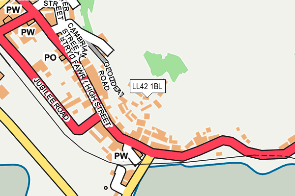
LL42 1BL is in Barmouth. LL42 1BL is located in the Abermaw electoral ward, within the unitary authority of Gwynedd and the Welsh Parliamentary constituency of Dwyfor Meirionnydd. The Local Health Board is Betsi Cadwaladr University and the police force is North Wales. This postcode has been in use since January 1980.


GetTheData
Source: OS OpenMap – Local (Ordnance Survey)
Source: OS VectorMap District (Ordnance Survey)
Licence: Open Government Licence (requires attribution)
| Easting | 261552 |
| Northing | 315672 |
| Latitude | 52.720931 |
| Longitude | -4.051291 |
GetTheData
Source: Open Postcode Geo
Licence: Open Government Licence
| Town/City | Barmouth |
| Country | Wales |
| Postcode District | LL42 |
➜ See where LL42 is on a map ➜ Where is Barmouth? | |
GetTheData
Source: Land Registry Price Paid Data
Licence: Open Government Licence
Elevation or altitude of LL42 1BL as distance above sea level:
| Metres | Feet | |
|---|---|---|
| Elevation | 40m | 131ft |
Elevation is measured from the approximate centre of the postcode, to the nearest point on an OS contour line from OS Terrain 50, which has contour spacing of ten vertical metres.
➜ How high above sea level am I? Find the elevation of your current position using your device's GPS.
GetTheData
Source: Open Postcode Elevation
Licence: Open Government Licence
| Ward | Abermaw |
| Constituency | Dwyfor Meirionnydd |
GetTheData
Source: ONS Postcode Database
Licence: Open Government Licence
TY'N-Y-FFYNNON COTTAGE, BARMOUTH, LL42 1BL 2015 9 SEP £130,000 |
GARREGLWYD, BARMOUTH, LL42 1BL 2007 30 NOV £175,000 |
GetTheData
Source: HM Land Registry Price Paid Data
Licence: Contains HM Land Registry data © Crown copyright and database right 2025. This data is licensed under the Open Government Licence v3.0.
| Last Inn (Church Street) | Barmouth | 117m |
| Last Inn (Church Street) | Barmouth | 125m |
| Bryn-y-mor (A496) | Barmouth | 151m |
| Post Office (High Street) | Barmouth | 186m |
| Jubilee Road | Barmouth | 308m |
| Barmouth Ferry (Fairbourne Railway) | Barmouth | 675m |
| Barmouth Station | 0.4km |
| Morfa Mawddach Station | 2km |
| Fairbourne Station | 2.8km |
GetTheData
Source: NaPTAN
Licence: Open Government Licence
| Percentage of properties with Next Generation Access | 100.0% |
| Percentage of properties with Superfast Broadband | 100.0% |
| Percentage of properties with Ultrafast Broadband | 0.0% |
| Percentage of properties with Full Fibre Broadband | 0.0% |
Superfast Broadband is between 30Mbps and 300Mbps
Ultrafast Broadband is > 300Mbps
| Percentage of properties unable to receive 2Mbps | 0.0% |
| Percentage of properties unable to receive 5Mbps | 0.0% |
| Percentage of properties unable to receive 10Mbps | 0.0% |
| Percentage of properties unable to receive 30Mbps | 0.0% |
GetTheData
Source: Ofcom
Licence: Ofcom Terms of Use (requires attribution)
Estimated total energy consumption in LL42 1BL by fuel type, 2015.
| Consumption (kWh) | 96,690 |
|---|---|
| Meter count | 8 |
| Mean (kWh/meter) | 12,086 |
| Median (kWh/meter) | 4,589 |
| Consumption (kWh) | 21,941 |
|---|---|
| Meter count | 9 |
| Mean (kWh/meter) | 2,438 |
| Median (kWh/meter) | 1,611 |
GetTheData
Source: Postcode level gas estimates: 2015 (experimental)
Source: Postcode level electricity estimates: 2015 (experimental)
Licence: Open Government Licence
GetTheData
Source: ONS Postcode Database
Licence: Open Government Licence


➜ Get more ratings from the Food Standards Agency
GetTheData
Source: Food Standards Agency
Licence: FSA terms & conditions
| Last Collection | |||
|---|---|---|---|
| Location | Mon-Fri | Sat | Distance |
| Barmouth Post Office | 16:45 | 11:30 | 178m |
| Beach Road | 16:45 | 11:00 | 341m |
| Alyn Road | 11:15 | 11:00 | 2,253m |
GetTheData
Source: Dracos
Licence: Creative Commons Attribution-ShareAlike
The below table lists the International Territorial Level (ITL) codes (formerly Nomenclature of Territorial Units for Statistics (NUTS) codes) and Local Administrative Units (LAU) codes for LL42 1BL:
| ITL 1 Code | Name |
|---|---|
| TLL | Wales |
| ITL 2 Code | Name |
| TLL1 | West Wales and The Valleys |
| ITL 3 Code | Name |
| TLL12 | Gwynedd |
| LAU 1 Code | Name |
| W06000002 | Gwynedd |
GetTheData
Source: ONS Postcode Directory
Licence: Open Government Licence
The below table lists the Census Output Area (OA), Lower Layer Super Output Area (LSOA), and Middle Layer Super Output Area (MSOA) for LL42 1BL:
| Code | Name | |
|---|---|---|
| OA | W00000244 | |
| LSOA | W01000049 | Gwynedd 016B |
| MSOA | W02000025 | Gwynedd 016 |
GetTheData
Source: ONS Postcode Directory
Licence: Open Government Licence
| LL42 1BN | St Georges | 16m |
| LL42 1BS | Gibraltar Lane | 41m |
| LL42 1BT | Bennar Terrace | 56m |
| LL42 1BW | St Georges Lane | 58m |
| LL42 1BY | Gibraltar Lane | 75m |
| LL42 1DB | Gibraltar Lane | 81m |
| LL42 1ED | St Georges Lane | 85m |
| LL42 1EG | Church Street | 86m |
| LL42 1DD | 88m | |
| LL42 1EH | Church Street | 95m |
GetTheData
Source: Open Postcode Geo; Land Registry Price Paid Data
Licence: Open Government Licence