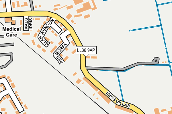
LL36 9AP lies on Sandilands Road in Tywyn. LL36 9AP is located in the Morfa Tywyn electoral ward, within the unitary authority of Gwynedd and the Welsh Parliamentary constituency of Dwyfor Meirionnydd. The Local Health Board is Betsi Cadwaladr University and the police force is North Wales. This postcode has been in use since January 1980.


GetTheData
Source: OS OpenMap – Local (Ordnance Survey)
Source: OS VectorMap District (Ordnance Survey)
Licence: Open Government Licence (requires attribution)
| Easting | 258104 |
| Northing | 300952 |
| Latitude | 52.587798 |
| Longitude | -4.095968 |
GetTheData
Source: Open Postcode Geo
Licence: Open Government Licence
| Street | Sandilands Road |
| Town/City | Tywyn |
| Country | Wales |
| Postcode District | LL36 |
➜ See where LL36 is on a map ➜ Where is Tywyn? | |
GetTheData
Source: Land Registry Price Paid Data
Licence: Open Government Licence
Elevation or altitude of LL36 9AP as distance above sea level:
| Metres | Feet | |
|---|---|---|
| Elevation | 10m | 33ft |
Elevation is measured from the approximate centre of the postcode, to the nearest point on an OS contour line from OS Terrain 50, which has contour spacing of ten vertical metres.
➜ How high above sea level am I? Find the elevation of your current position using your device's GPS.
GetTheData
Source: Open Postcode Elevation
Licence: Open Government Licence
| Ward | Morfa Tywyn |
| Constituency | Dwyfor Meirionnydd |
GetTheData
Source: ONS Postcode Database
Licence: Open Government Licence
DYSYNNI WHARF, SANDILANDS ROAD, TYWYN, LL36 9AP 1999 14 DEC £65,000 |
GetTheData
Source: HM Land Registry Price Paid Data
Licence: Contains HM Land Registry data © Crown copyright and database right 2025. This data is licensed under the Open Government Licence v3.0.
| Idris Villas (Sandilands Road) | Bryn-y-mor | 138m |
| Health Centre (Pier Road) | Bryn-y-mor | 285m |
| Station (Station Road) | Tywyn | 385m |
| Station (Station Road) | Tywyn | 387m |
| High Street | Tywyn | 517m |
| Tywyn Wharf (Talyllyn Railway) | Tywyn | 652m |
| Tywyn Pendre (Talyllyn Railway) | Pendre | 953m |
| Tywyn Station | 0.3km |
| Tonfanau Station | 3.4km |
| Aberdovey Station | 5.5km |
GetTheData
Source: NaPTAN
Licence: Open Government Licence
| Percentage of properties with Next Generation Access | 100.0% |
| Percentage of properties with Superfast Broadband | 100.0% |
| Percentage of properties with Ultrafast Broadband | 0.0% |
| Percentage of properties with Full Fibre Broadband | 0.0% |
Superfast Broadband is between 30Mbps and 300Mbps
Ultrafast Broadband is > 300Mbps
| Percentage of properties unable to receive 2Mbps | 0.0% |
| Percentage of properties unable to receive 5Mbps | 0.0% |
| Percentage of properties unable to receive 10Mbps | 0.0% |
| Percentage of properties unable to receive 30Mbps | 0.0% |
GetTheData
Source: Ofcom
Licence: Ofcom Terms of Use (requires attribution)
Estimated total energy consumption in LL36 9AP by fuel type, 2015.
| Consumption (kWh) | 32,884 |
|---|---|
| Meter count | 9 |
| Mean (kWh/meter) | 3,654 |
| Median (kWh/meter) | 2,771 |
GetTheData
Source: Postcode level gas estimates: 2015 (experimental)
Source: Postcode level electricity estimates: 2015 (experimental)
Licence: Open Government Licence
GetTheData
Source: ONS Postcode Database
Licence: Open Government Licence


➜ Get more ratings from the Food Standards Agency
GetTheData
Source: Food Standards Agency
Licence: FSA terms & conditions
| Last Collection | |||
|---|---|---|---|
| Location | Mon-Fri | Sat | Distance |
| Station Road | 16:00 | 10:00 | 332m |
| Tywyn Post Office | 17:00 | 11:45 | 420m |
| Library Neptune Road | 15:45 | 09:30 | 599m |
GetTheData
Source: Dracos
Licence: Creative Commons Attribution-ShareAlike
The below table lists the International Territorial Level (ITL) codes (formerly Nomenclature of Territorial Units for Statistics (NUTS) codes) and Local Administrative Units (LAU) codes for LL36 9AP:
| ITL 1 Code | Name |
|---|---|
| TLL | Wales |
| ITL 2 Code | Name |
| TLL1 | West Wales and The Valleys |
| ITL 3 Code | Name |
| TLL12 | Gwynedd |
| LAU 1 Code | Name |
| W06000002 | Gwynedd |
GetTheData
Source: ONS Postcode Directory
Licence: Open Government Licence
The below table lists the Census Output Area (OA), Lower Layer Super Output Area (LSOA), and Middle Layer Super Output Area (MSOA) for LL36 9AP:
| Code | Name | |
|---|---|---|
| OA | W00000605 | |
| LSOA | W01000117 | Gwynedd 017E |
| MSOA | W02000026 | Gwynedd 017 |
GetTheData
Source: ONS Postcode Directory
Licence: Open Government Licence
| LL36 9BL | Pen Morfa | 78m |
| LL36 9AW | Idris Villas | 153m |
| LL36 9AR | Maes Idris | 222m |
| LL36 0AL | Pier Road | 265m |
| LL36 0AN | 268m | |
| LL36 9AG | Bryn Mair | 288m |
| LL36 0AT | Pier Road | 309m |
| LL36 0AP | Pier Road | 326m |
| LL36 0AW | Maes Yr Heli | 327m |
| LL36 9AH | Station Road | 337m |
GetTheData
Source: Open Postcode Geo; Land Registry Price Paid Data
Licence: Open Government Licence