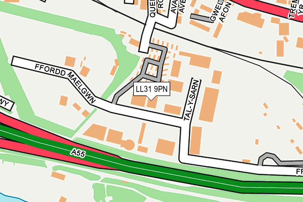
LL31 9PN is located in the Glyn y Marl electoral ward, within the unitary authority of Conwy and the Welsh Parliamentary constituency of Aberconwy. The Local Health Board is Betsi Cadwaladr University and the police force is North Wales. This postcode has been in use since July 1990.


GetTheData
Source: OS OpenMap – Local (Ordnance Survey)
Source: OS VectorMap District (Ordnance Survey)
Licence: Open Government Licence (requires attribution)
| Easting | 279889 |
| Northing | 377536 |
| Latitude | 53.281166 |
| Longitude | -3.802973 |
GetTheData
Source: Open Postcode Geo
Licence: Open Government Licence
| Country | Wales |
| Postcode District | LL31 |
➜ See where LL31 is on a map ➜ Where is Conwy? | |
GetTheData
Source: Land Registry Price Paid Data
Licence: Open Government Licence
Elevation or altitude of LL31 9PN as distance above sea level:
| Metres | Feet | |
|---|---|---|
| Elevation | 10m | 33ft |
Elevation is measured from the approximate centre of the postcode, to the nearest point on an OS contour line from OS Terrain 50, which has contour spacing of ten vertical metres.
➜ How high above sea level am I? Find the elevation of your current position using your device's GPS.
GetTheData
Source: Open Postcode Elevation
Licence: Open Government Licence
| Ward | Glyn Y Marl |
| Constituency | Aberconwy |
GetTheData
Source: ONS Postcode Database
Licence: Open Government Licence
| Preswylfa (Conway Road) | Llandudno Junction | 280m |
| Preswylfa (Conway Road) | Llandudno Junction | 303m |
| Trem Yr Afon (Conway Road) | Llandudno Junction | 318m |
| Trem Yr Afon (Conway Road) | Llandudno Junction | 324m |
| Maes Derw (Ronald Avenue) | Llandudno Junction | 375m |
| Llandudno Junction Station | 0.5km |
| Glan Conwy Station | 1.6km |
| Conwy Station | 1.8km |
GetTheData
Source: NaPTAN
Licence: Open Government Licence
GetTheData
Source: ONS Postcode Database
Licence: Open Government Licence


➜ Get more ratings from the Food Standards Agency
GetTheData
Source: Food Standards Agency
Licence: FSA terms & conditions
| Last Collection | |||
|---|---|---|---|
| Location | Mon-Fri | Sat | Distance |
| Tesco Llandudno Junction | 17:20 | 11:30 | 734m |
| Victoria Drive | 17:10 | 11:15 | 1,409m |
| Bryn Rhys | 15:30 | 09:00 | 1,450m |
GetTheData
Source: Dracos
Licence: Creative Commons Attribution-ShareAlike
The below table lists the International Territorial Level (ITL) codes (formerly Nomenclature of Territorial Units for Statistics (NUTS) codes) and Local Administrative Units (LAU) codes for LL31 9PN:
| ITL 1 Code | Name |
|---|---|
| TLL | Wales |
| ITL 2 Code | Name |
| TLL1 | West Wales and The Valleys |
| ITL 3 Code | Name |
| TLL13 | Conwy and Denbighshire |
| LAU 1 Code | Name |
| W06000003 | Conwy |
GetTheData
Source: ONS Postcode Directory
Licence: Open Government Licence
The below table lists the Census Output Area (OA), Lower Layer Super Output Area (LSOA), and Middle Layer Super Output Area (MSOA) for LL31 9PN:
| Code | Name | |
|---|---|---|
| OA | W00000945 | |
| LSOA | W01000176 | Conwy 011D |
| MSOA | W02000037 | Conwy 011 |
GetTheData
Source: ONS Postcode Directory
Licence: Open Government Licence
| LL31 9AB | River View Terrace | 122m |
| LL31 9GD | Gwel Yr Afon | 181m |
| LL31 9AD | Avallon Avenue | 195m |
| LL31 9AA | Queens Road | 210m |
| LL31 9EF | Kimberley Road | 215m |
| LL31 9BA | Conwy Road | 246m |
| LL31 9ED | Vale View Terrace | 251m |
| LL31 9EA | Roosevelt Terrace | 267m |
| LL31 9EE | Osborne Terrace | 270m |
| LL31 9DY | Mckinley Road | 289m |
GetTheData
Source: Open Postcode Geo; Land Registry Price Paid Data
Licence: Open Government Licence