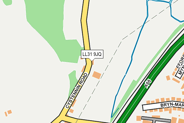
LL31 9JQ is located in the Penrhyn electoral ward, within the unitary authority of Conwy and the Welsh Parliamentary constituency of Aberconwy. The Local Health Board is Betsi Cadwaladr University and the police force is North Wales. This postcode has been in use since January 1980.


GetTheData
Source: OS OpenMap – Local (Ordnance Survey)
Source: OS VectorMap District (Ordnance Survey)
Licence: Open Government Licence (requires attribution)
| Easting | 282206 |
| Northing | 379218 |
| Latitude | 53.296798 |
| Longitude | -3.768863 |
GetTheData
Source: Open Postcode Geo
Licence: Open Government Licence
| Country | Wales |
| Postcode District | LL31 |
➜ See where LL31 is on a map ➜ Where is Llangwstenin? | |
GetTheData
Source: Land Registry Price Paid Data
Licence: Open Government Licence
Elevation or altitude of LL31 9JQ as distance above sea level:
| Metres | Feet | |
|---|---|---|
| Elevation | 10m | 33ft |
Elevation is measured from the approximate centre of the postcode, to the nearest point on an OS contour line from OS Terrain 50, which has contour spacing of ten vertical metres.
➜ How high above sea level am I? Find the elevation of your current position using your device's GPS.
GetTheData
Source: Open Postcode Elevation
Licence: Open Government Licence
| Ward | Penrhyn |
| Constituency | Aberconwy |
GetTheData
Source: ONS Postcode Database
Licence: Open Government Licence
| Wern Crescent (Conway Road) | Mochdre | 592m |
| Bevan Avenue (Conway Road) | Mochdre | 632m |
| Bevan Avenue (Conway Road) | Mochdre | 636m |
| Llys Ednyfed (Conway Road) | Mochdre | 655m |
| Bron-y-nant Cemetery (Bron-y-nant Road) | Llandrillo-yn-rhos | 662m |
| Colwyn Bay Station | 2.9km |
| Llandudno Junction Station | 3km |
| Glan Conwy Station | 3.8km |
GetTheData
Source: NaPTAN
Licence: Open Government Licence
| Percentage of properties with Next Generation Access | 100.0% |
| Percentage of properties with Superfast Broadband | 100.0% |
| Percentage of properties with Ultrafast Broadband | 0.0% |
| Percentage of properties with Full Fibre Broadband | 0.0% |
Superfast Broadband is between 30Mbps and 300Mbps
Ultrafast Broadband is > 300Mbps
| Percentage of properties unable to receive 2Mbps | 0.0% |
| Percentage of properties unable to receive 5Mbps | 0.0% |
| Percentage of properties unable to receive 10Mbps | 0.0% |
| Percentage of properties unable to receive 30Mbps | 0.0% |
GetTheData
Source: Ofcom
Licence: Ofcom Terms of Use (requires attribution)
GetTheData
Source: ONS Postcode Database
Licence: Open Government Licence


➜ Get more ratings from the Food Standards Agency
GetTheData
Source: Food Standards Agency
Licence: FSA terms & conditions
| Last Collection | |||
|---|---|---|---|
| Location | Mon-Fri | Sat | Distance |
| Mochdre Post Office | 17:15 | 11:30 | 680m |
| Brompton Avenue | 17:20 | 11:30 | 1,770m |
| Llandudno Road Post Office | 17:15 | 12:00 | 1,978m |
GetTheData
Source: Dracos
Licence: Creative Commons Attribution-ShareAlike
The below table lists the International Territorial Level (ITL) codes (formerly Nomenclature of Territorial Units for Statistics (NUTS) codes) and Local Administrative Units (LAU) codes for LL31 9JQ:
| ITL 1 Code | Name |
|---|---|
| TLL | Wales |
| ITL 2 Code | Name |
| TLL1 | West Wales and The Valleys |
| ITL 3 Code | Name |
| TLL13 | Conwy and Denbighshire |
| LAU 1 Code | Name |
| W06000003 | Conwy |
GetTheData
Source: ONS Postcode Directory
Licence: Open Government Licence
The below table lists the Census Output Area (OA), Lower Layer Super Output Area (LSOA), and Middle Layer Super Output Area (MSOA) for LL31 9JQ:
| Code | Name | |
|---|---|---|
| OA | W00000932 | |
| LSOA | W01000173 | Conwy 003B |
| MSOA | W02000029 | Conwy 003 |
GetTheData
Source: ONS Postcode Directory
Licence: Open Government Licence
| LL28 5DL | Ffordd Y Mynach | 411m |
| LL28 5DW | Ffordd Cwstenin | 415m |
| LL28 5DN | Ffordd Euryn | 452m |
| LL28 5DP | Ffordd Euryn | 474m |
| LL31 9JG | Tanrallt Cottages | 478m |
| LL28 5DA | Ffordd Y Bryn | 484m |
| LL28 5DH | Ffordd Y Maer | 487m |
| LL28 5DB | Ffordd Dyffryn | 494m |
| LL28 5DY | Orme Road | 508m |
| LL28 5BY | Ffordd Gobaith | 508m |
GetTheData
Source: Open Postcode Geo; Land Registry Price Paid Data
Licence: Open Government Licence