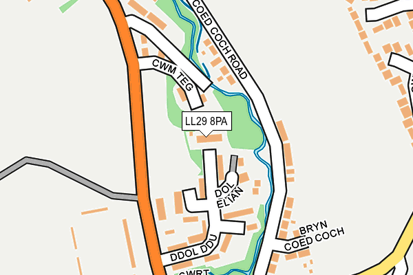
LL29 8PA lies on Ddol Ddu Isaf in Colwyn Bay. LL29 8PA is located in the Eirias electoral ward, within the unitary authority of Conwy and the Welsh Parliamentary constituency of Clwyd West. The Local Health Board is Betsi Cadwaladr University and the police force is North Wales. This postcode has been in use since April 1985.


GetTheData
Source: OS OpenMap – Local (Ordnance Survey)
Source: OS VectorMap District (Ordnance Survey)
Licence: Open Government Licence (requires attribution)
| Easting | 286934 |
| Northing | 377651 |
| Latitude | 53.283733 |
| Longitude | -3.697396 |
GetTheData
Source: Open Postcode Geo
Licence: Open Government Licence
| Street | Ddol Ddu Isaf |
| Town/City | Colwyn Bay |
| Country | Wales |
| Postcode District | LL29 |
➜ See where LL29 is on a map ➜ Where is Colwyn Bay? | |
GetTheData
Source: Land Registry Price Paid Data
Licence: Open Government Licence
Elevation or altitude of LL29 8PA as distance above sea level:
| Metres | Feet | |
|---|---|---|
| Elevation | 40m | 131ft |
Elevation is measured from the approximate centre of the postcode, to the nearest point on an OS contour line from OS Terrain 50, which has contour spacing of ten vertical metres.
➜ How high above sea level am I? Find the elevation of your current position using your device's GPS.
GetTheData
Source: Open Postcode Elevation
Licence: Open Government Licence
| Ward | Eirias |
| Constituency | Clwyd West |
GetTheData
Source: ONS Postcode Database
Licence: Open Government Licence
| Cefn Lodge (Coed Coch Road) | Old Colwyn | 95m |
| Football Ground (Llanelian Road) | Old Colwyn | 137m |
| Football Ground (Llanelian Road) | Old Colwyn | 144m |
| Peulwys Lane (Coed Coch Road) | Old Colwyn | 217m |
| Pentre Newydd (Llanellan Road) | Old Colwyn | 338m |
| Colwyn Bay Station | 2.3km |
GetTheData
Source: NaPTAN
Licence: Open Government Licence
| Percentage of properties with Next Generation Access | 100.0% |
| Percentage of properties with Superfast Broadband | 100.0% |
| Percentage of properties with Ultrafast Broadband | 0.0% |
| Percentage of properties with Full Fibre Broadband | 0.0% |
Superfast Broadband is between 30Mbps and 300Mbps
Ultrafast Broadband is > 300Mbps
| Median download speed | 20.3Mbps |
| Average download speed | 27.1Mbps |
| Maximum download speed | 51.37Mbps |
| Median upload speed | 3.1Mbps |
| Average upload speed | 4.1Mbps |
| Maximum upload speed | 9.37Mbps |
| Percentage of properties unable to receive 2Mbps | 0.0% |
| Percentage of properties unable to receive 5Mbps | 0.0% |
| Percentage of properties unable to receive 10Mbps | 0.0% |
| Percentage of properties unable to receive 30Mbps | 0.0% |
GetTheData
Source: Ofcom
Licence: Ofcom Terms of Use (requires attribution)
Estimated total energy consumption in LL29 8PA by fuel type, 2015.
| Consumption (kWh) | 61,756 |
|---|---|
| Meter count | 6 |
| Mean (kWh/meter) | 10,293 |
| Median (kWh/meter) | 10,813 |
GetTheData
Source: Postcode level gas estimates: 2015 (experimental)
Source: Postcode level electricity estimates: 2015 (experimental)
Licence: Open Government Licence
GetTheData
Source: ONS Postcode Database
Licence: Open Government Licence


➜ Get more ratings from the Food Standards Agency
GetTheData
Source: Food Standards Agency
Licence: FSA terms & conditions
| Last Collection | |||
|---|---|---|---|
| Location | Mon-Fri | Sat | Distance |
| Glyn Estate | 17:10 | 11:15 | 1,053m |
| Abergele Road Post Office | 17:15 | 12:00 | 1,859m |
| Greenfield Road | 17:15 | 11:30 | 2,000m |
GetTheData
Source: Dracos
Licence: Creative Commons Attribution-ShareAlike
The below table lists the International Territorial Level (ITL) codes (formerly Nomenclature of Territorial Units for Statistics (NUTS) codes) and Local Administrative Units (LAU) codes for LL29 8PA:
| ITL 1 Code | Name |
|---|---|
| TLL | Wales |
| ITL 2 Code | Name |
| TLL1 | West Wales and The Valleys |
| ITL 3 Code | Name |
| TLL13 | Conwy and Denbighshire |
| LAU 1 Code | Name |
| W06000003 | Conwy |
GetTheData
Source: ONS Postcode Directory
Licence: Open Government Licence
The below table lists the Census Output Area (OA), Lower Layer Super Output Area (LSOA), and Middle Layer Super Output Area (MSOA) for LL29 8PA:
| Code | Name | |
|---|---|---|
| OA | W00000744 | |
| LSOA | W01000138 | Conwy 008A |
| MSOA | W02000034 | Conwy 008 |
GetTheData
Source: ONS Postcode Directory
Licence: Open Government Licence
| LL29 8ZA | Cwm Teg | 79m |
| LL29 8YH | Ddol Ddu | 124m |
| LL29 9UN | Coed Coch Road | 156m |
| LL29 9RA | Bryn Coed Coch | 218m |
| LL29 9UW | Coed Coch Road | 236m |
| LL29 8UN | Llanelian Road | 263m |
| LL29 8YD | Peulwys Lane | 275m |
| LL29 9UH | Llanelian Road | 294m |
| LL29 9PB | Hayden Close | 303m |
| LL29 8NY | Llys Pentre Isaf | 353m |
GetTheData
Source: Open Postcode Geo; Land Registry Price Paid Data
Licence: Open Government Licence