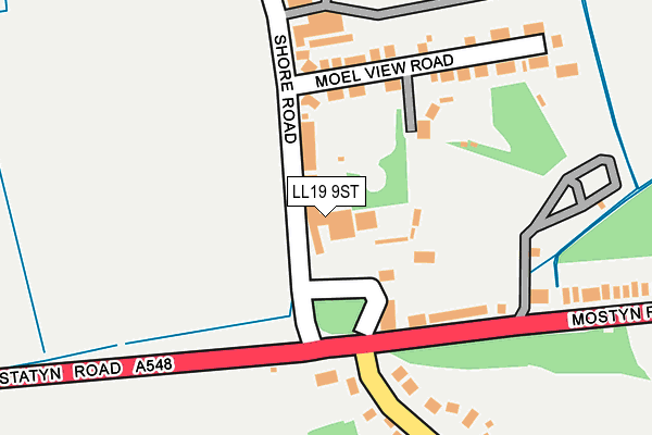
LL19 9ST is located in the Llanasa and Trelawnyd electoral ward, within the unitary authority of Flintshire and the Welsh Parliamentary constituency of Delyn. The Local Health Board is Betsi Cadwaladr University and the police force is North Wales. This postcode has been in use since January 1980.


GetTheData
Source: OS OpenMap – Local (Ordnance Survey)
Source: OS VectorMap District (Ordnance Survey)
Licence: Open Government Licence (requires attribution)
| Easting | 309107 |
| Northing | 383591 |
| Latitude | 53.341381 |
| Longitude | -3.366632 |
GetTheData
Source: Open Postcode Geo
Licence: Open Government Licence
| Country | Wales |
| Postcode District | LL19 |
➜ See where LL19 is on a map ➜ Where is Gronant? | |
GetTheData
Source: Land Registry Price Paid Data
Licence: Open Government Licence
Elevation or altitude of LL19 9ST as distance above sea level:
| Metres | Feet | |
|---|---|---|
| Elevation | 10m | 33ft |
Elevation is measured from the approximate centre of the postcode, to the nearest point on an OS contour line from OS Terrain 50, which has contour spacing of ten vertical metres.
➜ How high above sea level am I? Find the elevation of your current position using your device's GPS.
GetTheData
Source: Open Postcode Elevation
Licence: Open Government Licence
| Ward | Llanasa And Trelawnyd |
| Constituency | Delyn |
GetTheData
Source: ONS Postcode Database
Licence: Open Government Licence
| Crossroads (Prestatyn Road) | Gronant | 134m |
| Crossroads (Gronant Hill) | Gronant | 147m |
| Crossroads (Mostyn Road) | Gronant | 182m |
| Llys Dewi (Nant-y-gro) | Gronant | 379m |
| Llys Dewi (Nant-y-gro) | Gronant | 385m |
| Prestatyn Station | 2.8km |
GetTheData
Source: NaPTAN
Licence: Open Government Licence
GetTheData
Source: ONS Postcode Database
Licence: Open Government Licence


➜ Get more ratings from the Food Standards Agency
GetTheData
Source: Food Standards Agency
Licence: FSA terms & conditions
| Last Collection | |||
|---|---|---|---|
| Location | Mon-Fri | Sat | Distance |
| Shore Road | 16:15 | 09:00 | 117m |
| Presthaven Sands | 16:30 | 07:00 | 1,449m |
| Prestatyn Main Post Office | 17:25 | 12:00 | 2,668m |
GetTheData
Source: Dracos
Licence: Creative Commons Attribution-ShareAlike
The below table lists the International Territorial Level (ITL) codes (formerly Nomenclature of Territorial Units for Statistics (NUTS) codes) and Local Administrative Units (LAU) codes for LL19 9ST:
| ITL 1 Code | Name |
|---|---|
| TLL | Wales |
| ITL 2 Code | Name |
| TLL2 | East Wales |
| ITL 3 Code | Name |
| TLL23 | Flintshire and Wrexham |
| LAU 1 Code | Name |
| W06000005 | Flintshire |
GetTheData
Source: ONS Postcode Directory
Licence: Open Government Licence
The below table lists the Census Output Area (OA), Lower Layer Super Output Area (LSOA), and Middle Layer Super Output Area (MSOA) for LL19 9ST:
| Code | Name | |
|---|---|---|
| OA | W00001594 | |
| LSOA | W01000298 | Flintshire 001B |
| MSOA | W02000058 | Flintshire 001 |
GetTheData
Source: ONS Postcode Directory
Licence: Open Government Licence
| LL19 9SS | Shore Road | 151m |
| LL19 9SU | Moel View Road | 163m |
| LL19 9SY | Mostyn Road | 210m |
| LL19 9SR | Gronant Hill | 268m |
| LL19 9TA | Mostyn Road | 350m |
| LL19 9SP | Llanasa Road | 376m |
| LL19 9TJ | Llys Owen | 418m |
| LL19 9TQ | Llys Dewi | 447m |
| LL19 9TN | Maes Y Dre | 484m |
| LL19 9UG | Bryn Awelon | 496m |
GetTheData
Source: Open Postcode Geo; Land Registry Price Paid Data
Licence: Open Government Licence