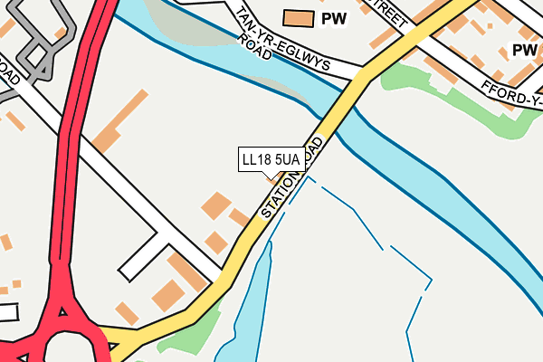
LL18 5UA lies on Station Road in Rhuddlan, Rhyl. LL18 5UA is located in the Rhuddlan electoral ward, within the unitary authority of Denbighshire and the Welsh Parliamentary constituency of Vale of Clwyd. The Local Health Board is Betsi Cadwaladr University and the police force is North Wales. This postcode has been in use since January 1980.


GetTheData
Source: OS OpenMap – Local (Ordnance Survey)
Source: OS VectorMap District (Ordnance Survey)
Licence: Open Government Licence (requires attribution)
| Easting | 302113 |
| Northing | 377918 |
| Latitude | 53.289155 |
| Longitude | -3.469889 |
GetTheData
Source: Open Postcode Geo
Licence: Open Government Licence
| Street | Station Road |
| Locality | Rhuddlan |
| Town/City | Rhyl |
| Country | Wales |
| Postcode District | LL18 |
➜ See where LL18 is on a map ➜ Where is Rhuddlan? | |
GetTheData
Source: Land Registry Price Paid Data
Licence: Open Government Licence
Elevation or altitude of LL18 5UA as distance above sea level:
| Metres | Feet | |
|---|---|---|
| Elevation | 10m | 33ft |
Elevation is measured from the approximate centre of the postcode, to the nearest point on an OS contour line from OS Terrain 50, which has contour spacing of ten vertical metres.
➜ How high above sea level am I? Find the elevation of your current position using your device's GPS.
GetTheData
Source: Open Postcode Elevation
Licence: Open Government Licence
| Ward | Rhuddlan |
| Constituency | Vale Of Clwyd |
GetTheData
Source: ONS Postcode Database
Licence: Open Government Licence
2023 31 AUG £120,000 |
2014 14 MAY £65,000 |
2008 4 AUG £140,000 |
2003 21 NOV £50,000 |
TOWN & COUNTRY RESTAURANT, STATION ROAD, RHUDDLAN, RHYL, LL18 5UA 2001 26 OCT £100,000 |
GetTheData
Source: HM Land Registry Price Paid Data
Licence: Contains HM Land Registry data © Crown copyright and database right 2025. This data is licensed under the Open Government Licence v3.0.
| Marsh Warden (Station Road) | Rhuddlan | 67m |
| Marsh Warden (Station Road) | Rhuddlan | 71m |
| Parliament House (Station Road) | Rhuddlan | 207m |
| Kings Head (Princes Road) | Rhuddlan | 430m |
| Vicarage Lane (Rhyl Road) | Rhuddlan | 474m |
| Rhyl Station | 3.5km |
GetTheData
Source: NaPTAN
Licence: Open Government Licence
| Percentage of properties with Next Generation Access | 100.0% |
| Percentage of properties with Superfast Broadband | 100.0% |
| Percentage of properties with Ultrafast Broadband | 100.0% |
| Percentage of properties with Full Fibre Broadband | 100.0% |
Superfast Broadband is between 30Mbps and 300Mbps
Ultrafast Broadband is > 300Mbps
| Percentage of properties unable to receive 2Mbps | 0.0% |
| Percentage of properties unable to receive 5Mbps | 0.0% |
| Percentage of properties unable to receive 10Mbps | 0.0% |
| Percentage of properties unable to receive 30Mbps | 0.0% |
GetTheData
Source: Ofcom
Licence: Ofcom Terms of Use (requires attribution)
GetTheData
Source: ONS Postcode Database
Licence: Open Government Licence


➜ Get more ratings from the Food Standards Agency
GetTheData
Source: Food Standards Agency
Licence: FSA terms & conditions
| Last Collection | |||
|---|---|---|---|
| Location | Mon-Fri | Sat | Distance |
| St Margarets Drive | 17:15 | 11:00 | 639m |
| Cwm Road | 17:15 | 09:00 | 3,743m |
| Dyserth Post Office | 17:20 | 11:00 | 3,953m |
GetTheData
Source: Dracos
Licence: Creative Commons Attribution-ShareAlike
The below table lists the International Territorial Level (ITL) codes (formerly Nomenclature of Territorial Units for Statistics (NUTS) codes) and Local Administrative Units (LAU) codes for LL18 5UA:
| ITL 1 Code | Name |
|---|---|
| TLL | Wales |
| ITL 2 Code | Name |
| TLL1 | West Wales and The Valleys |
| ITL 3 Code | Name |
| TLL13 | Conwy and Denbighshire |
| LAU 1 Code | Name |
| W06000004 | Denbighshire |
GetTheData
Source: ONS Postcode Directory
Licence: Open Government Licence
The below table lists the Census Output Area (OA), Lower Layer Super Output Area (LSOA), and Middle Layer Super Output Area (MSOA) for LL18 5UA:
| Code | Name | |
|---|---|---|
| OA | W00001202 | |
| LSOA | W01000223 | Denbighshire 009B |
| MSOA | W02000050 | Denbighshire 009 |
GetTheData
Source: ONS Postcode Directory
Licence: Open Government Licence
| LL18 2UY | Pen Y Bont | 206m |
| LL18 2UD | Vale View | 209m |
| LL18 5UB | Marsh Road | 213m |
| LL18 2UU | Tan Yr Eglwys Road | 241m |
| LL18 2YA | Church Street | 249m |
| LL18 5AB | Castle Street | 256m |
| LL18 2TY | High Street | 265m |
| LL18 2UB | High Street | 267m |
| LL18 2UT | Tan Yr Eglwys Road | 297m |
| LL18 5AH | Cross Street | 308m |
GetTheData
Source: Open Postcode Geo; Land Registry Price Paid Data
Licence: Open Government Licence