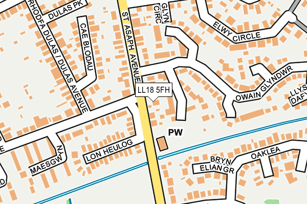
LL18 5FH lies on St Asaph Avenue in Kinmel Bay, Rhyl. LL18 5FH is located in the Kinmel Bay electoral ward, within the unitary authority of Conwy and the Welsh Parliamentary constituency of Clwyd West. The Local Health Board is Betsi Cadwaladr University and the police force is North Wales. This postcode has been in use since December 1996.


GetTheData
Source: OS OpenMap – Local (Ordnance Survey)
Source: OS VectorMap District (Ordnance Survey)
Licence: Open Government Licence (requires attribution)
| Easting | 299017 |
| Northing | 379599 |
| Latitude | 53.303696 |
| Longitude | -3.516853 |
GetTheData
Source: Open Postcode Geo
Licence: Open Government Licence
| Street | St Asaph Avenue |
| Locality | Kinmel Bay |
| Town/City | Rhyl |
| Country | Wales |
| Postcode District | LL18 |
➜ See where LL18 is on a map ➜ Where is Kinmel Bay? | |
GetTheData
Source: Land Registry Price Paid Data
Licence: Open Government Licence
Elevation or altitude of LL18 5FH as distance above sea level:
| Metres | Feet | |
|---|---|---|
| Elevation | 10m | 33ft |
Elevation is measured from the approximate centre of the postcode, to the nearest point on an OS contour line from OS Terrain 50, which has contour spacing of ten vertical metres.
➜ How high above sea level am I? Find the elevation of your current position using your device's GPS.
GetTheData
Source: Open Postcode Elevation
Licence: Open Government Licence
| Ward | Kinmel Bay |
| Constituency | Clwyd West |
GetTheData
Source: ONS Postcode Database
Licence: Open Government Licence
| Maesgwyn (Rhodfa Caer) | Kinmel Bay | 230m |
| Oajlea (Clwyd Park) | Kinmel Bay | 273m |
| Dulas Avenue (Cader Avenue) | Kinmel Bay | 327m |
| Llugwy Road Middle (Heol Llugwy) | Kinmel Bay | 356m |
| St Asaph Avenue | Kinmel Bay | 438m |
| Rhyl Station | 2.5km |
| Abergele & Pensarn Station | 4.5km |
GetTheData
Source: NaPTAN
Licence: Open Government Licence
| Percentage of properties with Next Generation Access | 100.0% |
| Percentage of properties with Superfast Broadband | 100.0% |
| Percentage of properties with Ultrafast Broadband | 0.0% |
| Percentage of properties with Full Fibre Broadband | 0.0% |
Superfast Broadband is between 30Mbps and 300Mbps
Ultrafast Broadband is > 300Mbps
| Percentage of properties unable to receive 2Mbps | 0.0% |
| Percentage of properties unable to receive 5Mbps | 0.0% |
| Percentage of properties unable to receive 10Mbps | 0.0% |
| Percentage of properties unable to receive 30Mbps | 0.0% |
GetTheData
Source: Ofcom
Licence: Ofcom Terms of Use (requires attribution)
GetTheData
Source: ONS Postcode Database
Licence: Open Government Licence


➜ Get more ratings from the Food Standards Agency
GetTheData
Source: Food Standards Agency
Licence: FSA terms & conditions
| Last Collection | |||
|---|---|---|---|
| Location | Mon-Fri | Sat | Distance |
| Marine Drive | 16:45 | 10:30 | 3,072m |
| St Margarets Drive | 17:15 | 11:00 | 3,513m |
| Maes Y Dre | 16:45 | 11:00 | 4,544m |
GetTheData
Source: Dracos
Licence: Creative Commons Attribution-ShareAlike
The below table lists the International Territorial Level (ITL) codes (formerly Nomenclature of Territorial Units for Statistics (NUTS) codes) and Local Administrative Units (LAU) codes for LL18 5FH:
| ITL 1 Code | Name |
|---|---|
| TLL | Wales |
| ITL 2 Code | Name |
| TLL1 | West Wales and The Valleys |
| ITL 3 Code | Name |
| TLL13 | Conwy and Denbighshire |
| LAU 1 Code | Name |
| W06000003 | Conwy |
GetTheData
Source: ONS Postcode Directory
Licence: Open Government Licence
The below table lists the Census Output Area (OA), Lower Layer Super Output Area (LSOA), and Middle Layer Super Output Area (MSOA) for LL18 5FH:
| Code | Name | |
|---|---|---|
| OA | W00000797 | |
| LSOA | W01000151 | Conwy 005C |
| MSOA | W02000031 | Conwy 005 |
GetTheData
Source: ONS Postcode Directory
Licence: Open Government Licence
| LL18 5FF | Owain Gwynedd | 71m |
| LL18 5EY | St Asaph Avenue | 91m |
| LL18 5FG | Cadwalader | 122m |
| LL18 5NQ | Lon Heulog | 130m |
| LL18 5LX | Cae Blodau | 142m |
| LL18 5FP | Llys Trahaearn | 166m |
| LL18 5HJ | Bryn Elian Grove | 185m |
| LL18 5FR | Llys Cynffig | 203m |
| LL18 5HE | Glyn Circle | 213m |
| LL18 5LB | Dulas Avenue | 216m |
GetTheData
Source: Open Postcode Geo; Land Registry Price Paid Data
Licence: Open Government Licence