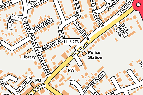
LL18 2TS lies on Rhyl Road in Rhuddlan, Rhyl. LL18 2TS is located in the Rhuddlan electoral ward, within the unitary authority of Denbighshire and the Welsh Parliamentary constituency of Vale of Clwyd. The Local Health Board is Betsi Cadwaladr University and the police force is North Wales. This postcode has been in use since January 1980.


GetTheData
Source: OS OpenMap – Local (Ordnance Survey)
Source: OS VectorMap District (Ordnance Survey)
Licence: Open Government Licence (requires attribution)
| Easting | 302546 |
| Northing | 378350 |
| Latitude | 53.293117 |
| Longitude | -3.463529 |
GetTheData
Source: Open Postcode Geo
Licence: Open Government Licence
| Street | Rhyl Road |
| Locality | Rhuddlan |
| Town/City | Rhyl |
| Country | Wales |
| Postcode District | LL18 |
➜ See where LL18 is on a map ➜ Where is Rhuddlan? | |
GetTheData
Source: Land Registry Price Paid Data
Licence: Open Government Licence
Elevation or altitude of LL18 2TS as distance above sea level:
| Metres | Feet | |
|---|---|---|
| Elevation | 10m | 33ft |
Elevation is measured from the approximate centre of the postcode, to the nearest point on an OS contour line from OS Terrain 50, which has contour spacing of ten vertical metres.
➜ How high above sea level am I? Find the elevation of your current position using your device's GPS.
GetTheData
Source: Open Postcode Elevation
Licence: Open Government Licence
| Ward | Rhuddlan |
| Constituency | Vale Of Clwyd |
GetTheData
Source: ONS Postcode Database
Licence: Open Government Licence
EILDON, RHYL ROAD, RHUDDLAN, RHYL, LL18 2TS 2013 17 MAY £100,000 |
COEDLYS, RHYL ROAD, RHUDDLAN, RHYL, LL18 2TS 2001 2 OCT £59,500 |
COEDLYS, RHYL ROAD, RHUDDLAN, RHYL, LL18 2TS 1998 4 DEC £42,500 |
PENRHOS, RHYL ROAD, RHUDDLAN, RHYL, LL18 2TS 1998 27 FEB £59,800 |
GetTheData
Source: HM Land Registry Price Paid Data
Licence: Contains HM Land Registry data © Crown copyright and database right 2025. This data is licensed under the Open Government Licence v3.0.
| Treetops Court (Rhyl Road) | Rhuddlan | 56m |
| Ffordd Dewi (Rhyl Road) | Pen-y-ffordd | 134m |
| Vicarage Lane (Rhyl Road) | Rhuddlan | 139m |
| Kings Head (Princes Road) | Rhuddlan | 190m |
| Haulfre (Rhyl Road) | Pen-y-ffordd | 230m |
| Rhyl Station | 3.3km |
| Prestatyn Station | 6.1km |
GetTheData
Source: NaPTAN
Licence: Open Government Licence
| Percentage of properties with Next Generation Access | 100.0% |
| Percentage of properties with Superfast Broadband | 100.0% |
| Percentage of properties with Ultrafast Broadband | 0.0% |
| Percentage of properties with Full Fibre Broadband | 0.0% |
Superfast Broadband is between 30Mbps and 300Mbps
Ultrafast Broadband is > 300Mbps
| Median download speed | 23.9Mbps |
| Average download speed | 37.4Mbps |
| Maximum download speed | 78.12Mbps |
| Median upload speed | 9.8Mbps |
| Average upload speed | 8.1Mbps |
| Maximum upload speed | 19.53Mbps |
| Percentage of properties unable to receive 2Mbps | 0.0% |
| Percentage of properties unable to receive 5Mbps | 0.0% |
| Percentage of properties unable to receive 10Mbps | 0.0% |
| Percentage of properties unable to receive 30Mbps | 0.0% |
GetTheData
Source: Ofcom
Licence: Ofcom Terms of Use (requires attribution)
Estimated total energy consumption in LL18 2TS by fuel type, 2015.
| Consumption (kWh) | 143,090 |
|---|---|
| Meter count | 8 |
| Mean (kWh/meter) | 17,886 |
| Median (kWh/meter) | 13,636 |
| Consumption (kWh) | 26,970 |
|---|---|
| Meter count | 7 |
| Mean (kWh/meter) | 3,853 |
| Median (kWh/meter) | 4,008 |
GetTheData
Source: Postcode level gas estimates: 2015 (experimental)
Source: Postcode level electricity estimates: 2015 (experimental)
Licence: Open Government Licence
GetTheData
Source: ONS Postcode Database
Licence: Open Government Licence


➜ Get more ratings from the Food Standards Agency
GetTheData
Source: Food Standards Agency
Licence: FSA terms & conditions
| Last Collection | |||
|---|---|---|---|
| Location | Mon-Fri | Sat | Distance |
| St Margarets Drive | 17:15 | 11:00 | 247m |
| Cwm Road | 17:15 | 09:00 | 3,222m |
| Dyserth Post Office | 17:20 | 11:00 | 3,423m |
GetTheData
Source: Dracos
Licence: Creative Commons Attribution-ShareAlike
The below table lists the International Territorial Level (ITL) codes (formerly Nomenclature of Territorial Units for Statistics (NUTS) codes) and Local Administrative Units (LAU) codes for LL18 2TS:
| ITL 1 Code | Name |
|---|---|
| TLL | Wales |
| ITL 2 Code | Name |
| TLL1 | West Wales and The Valleys |
| ITL 3 Code | Name |
| TLL13 | Conwy and Denbighshire |
| LAU 1 Code | Name |
| W06000004 | Denbighshire |
GetTheData
Source: ONS Postcode Directory
Licence: Open Government Licence
The below table lists the Census Output Area (OA), Lower Layer Super Output Area (LSOA), and Middle Layer Super Output Area (MSOA) for LL18 2TS:
| Code | Name | |
|---|---|---|
| OA | W00001197 | |
| LSOA | W01000224 | Denbighshire 009C |
| MSOA | W02000050 | Denbighshire 009 |
GetTheData
Source: ONS Postcode Directory
Licence: Open Government Licence
| LL18 2UG | Berllan Avenue | 71m |
| LL18 2TX | Rhyl Road | 77m |
| LL18 2TZ | Rhyl Road | 87m |
| LL18 2TQ | Tree Tops Court | 99m |
| LL18 2TW | Ffordd Dewi | 100m |
| LL18 2TN | Rhyl Road | 113m |
| LL18 2UE | Vicarage Lane | 123m |
| LL18 2TR | Rhyl Road | 124m |
| LL18 2UP | Eton Park | 132m |
| LL18 5YE | Hendre Close | 154m |
GetTheData
Source: Open Postcode Geo; Land Registry Price Paid Data
Licence: Open Government Licence