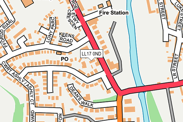
LL17 0ND lies on Merllyn Terrace in St Asaph. LL17 0ND is located in the St Asaph West electoral ward, within the unitary authority of Denbighshire and the Welsh Parliamentary constituency of Vale of Clwyd. The Local Health Board is Betsi Cadwaladr University and the police force is North Wales. This postcode has been in use since January 1980.


GetTheData
Source: OS OpenMap – Local (Ordnance Survey)
Source: OS VectorMap District (Ordnance Survey)
Licence: Open Government Licence (requires attribution)
| Easting | 303365 |
| Northing | 374334 |
| Latitude | 53.257180 |
| Longitude | -3.450024 |
GetTheData
Source: Open Postcode Geo
Licence: Open Government Licence
| Street | Merllyn Terrace |
| Town/City | St Asaph |
| Country | Wales |
| Postcode District | LL17 |
➜ See where LL17 is on a map ➜ Where is St Asaph? | |
GetTheData
Source: Land Registry Price Paid Data
Licence: Open Government Licence
Elevation or altitude of LL17 0ND as distance above sea level:
| Metres | Feet | |
|---|---|---|
| Elevation | 20m | 66ft |
Elevation is measured from the approximate centre of the postcode, to the nearest point on an OS contour line from OS Terrain 50, which has contour spacing of ten vertical metres.
➜ How high above sea level am I? Find the elevation of your current position using your device's GPS.
GetTheData
Source: Open Postcode Elevation
Licence: Open Government Licence
| Ward | St Asaph West |
| Constituency | Vale Of Clwyd |
GetTheData
Source: ONS Postcode Database
Licence: Open Government Licence
| Health Centre (The Roe) | The Roe | 42m |
| Ashley Court (The Roe) | The Roe | 83m |
| Plough Hotel (The Roe) | The Roe | 149m |
| Swan Inn (The Roe) | The Roe | 164m |
| Kwik Save (Lower Denbigh Road) | The Roe | 204m |
GetTheData
Source: NaPTAN
Licence: Open Government Licence
| Percentage of properties with Next Generation Access | 100.0% |
| Percentage of properties with Superfast Broadband | 100.0% |
| Percentage of properties with Ultrafast Broadband | 0.0% |
| Percentage of properties with Full Fibre Broadband | 0.0% |
Superfast Broadband is between 30Mbps and 300Mbps
Ultrafast Broadband is > 300Mbps
| Percentage of properties unable to receive 2Mbps | 0.0% |
| Percentage of properties unable to receive 5Mbps | 0.0% |
| Percentage of properties unable to receive 10Mbps | 0.0% |
| Percentage of properties unable to receive 30Mbps | 0.0% |
GetTheData
Source: Ofcom
Licence: Ofcom Terms of Use (requires attribution)
GetTheData
Source: ONS Postcode Database
Licence: Open Government Licence


➜ Get more ratings from the Food Standards Agency
GetTheData
Source: Food Standards Agency
Licence: FSA terms & conditions
| Last Collection | |||
|---|---|---|---|
| Location | Mon-Fri | Sat | Distance |
| Foxtons | 17:00 | 11:00 | 268m |
| St Asaph Business Park | 16:45 | 10:30 | 1,508m |
| Eryl | 16:15 | 08:00 | 1,576m |
GetTheData
Source: Dracos
Licence: Creative Commons Attribution-ShareAlike
The below table lists the International Territorial Level (ITL) codes (formerly Nomenclature of Territorial Units for Statistics (NUTS) codes) and Local Administrative Units (LAU) codes for LL17 0ND:
| ITL 1 Code | Name |
|---|---|
| TLL | Wales |
| ITL 2 Code | Name |
| TLL1 | West Wales and The Valleys |
| ITL 3 Code | Name |
| TLL13 | Conwy and Denbighshire |
| LAU 1 Code | Name |
| W06000004 | Denbighshire |
GetTheData
Source: ONS Postcode Directory
Licence: Open Government Licence
The below table lists the Census Output Area (OA), Lower Layer Super Output Area (LSOA), and Middle Layer Super Output Area (MSOA) for LL17 0ND:
| Code | Name | |
|---|---|---|
| OA | W00001320 | |
| LSOA | W01000246 | Denbighshire 010B |
| MSOA | W02000051 | Denbighshire 010 |
GetTheData
Source: ONS Postcode Directory
Licence: Open Government Licence
| LL17 0PN | Heol Esgob | 84m |
| LL17 0PG | Ashly Court | 102m |
| LL17 0LU | The Roe | 110m |
| LL17 0PS | Keens Row | 111m |
| LL17 0NE | Deans Walk | 119m |
| LL17 0PR | Keens Road | 123m |
| LL17 0NB | Elwy Crescent | 144m |
| LL17 0PJ | Lon Y Parc | 180m |
| LL17 0PL | Ashly Court | 196m |
| LL17 0NH | Penrhewl | 196m |
GetTheData
Source: Open Postcode Geo; Land Registry Price Paid Data
Licence: Open Government Licence