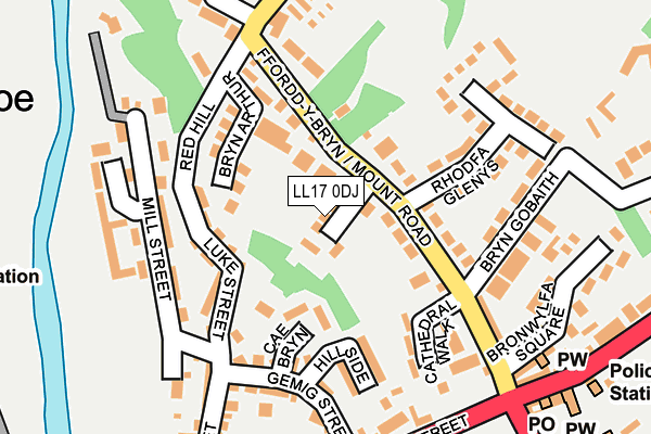
LL17 0DJ lies on Llys Trewithan in St. Asaph. LL17 0DJ is located in the St Asaph East electoral ward, within the unitary authority of Denbighshire and the Welsh Parliamentary constituency of Vale of Clwyd. The Local Health Board is Betsi Cadwaladr University and the police force is North Wales. This postcode has been in use since January 1983.


GetTheData
Source: OS OpenMap – Local (Ordnance Survey)
Source: OS VectorMap District (Ordnance Survey)
Licence: Open Government Licence (requires attribution)
| Easting | 303750 |
| Northing | 374547 |
| Latitude | 53.259164 |
| Longitude | -3.444319 |
GetTheData
Source: Open Postcode Geo
Licence: Open Government Licence
| Street | Llys Trewithan |
| Town/City | St. Asaph |
| Country | Wales |
| Postcode District | LL17 |
➜ See where LL17 is on a map ➜ Where is St Asaph? | |
GetTheData
Source: Land Registry Price Paid Data
Licence: Open Government Licence
Elevation or altitude of LL17 0DJ as distance above sea level:
| Metres | Feet | |
|---|---|---|
| Elevation | 30m | 98ft |
Elevation is measured from the approximate centre of the postcode, to the nearest point on an OS contour line from OS Terrain 50, which has contour spacing of ten vertical metres.
➜ How high above sea level am I? Find the elevation of your current position using your device's GPS.
GetTheData
Source: Open Postcode Elevation
Licence: Open Government Licence
| Ward | St Asaph East |
| Constituency | Vale Of Clwyd |
GetTheData
Source: ONS Postcode Database
Licence: Open Government Licence
5, LLYS TREWITHAN, ST ASAPH, LL17 0DJ 2024 1 NOV £220,500 |
2024 7 AUG £415,000 |
2018 4 DEC £235,000 |
2018 22 AUG £230,000 |
2017 3 AUG £305,000 |
2014 24 OCT £220,000 |
2005 7 JAN £215,000 |
2003 14 NOV £165,000 |
2000 25 OCT £112,500 |
1999 27 MAY £85,000 |
GetTheData
Source: HM Land Registry Price Paid Data
Licence: Contains HM Land Registry data © Crown copyright and database right 2025. This data is licensed under the Open Government Licence v3.0.
| Cathedral (High Street) | St Asaph | 223m |
| Cathedral (High Street) | St Asaph | 226m |
| Fountain Garage (High Street) | St Asaph | 317m |
| Fountain Garage (High Street) | St Asaph | 330m |
| Health Centre (The Roe) | The Roe | 406m |
GetTheData
Source: NaPTAN
Licence: Open Government Licence
| Percentage of properties with Next Generation Access | 100.0% |
| Percentage of properties with Superfast Broadband | 100.0% |
| Percentage of properties with Ultrafast Broadband | 0.0% |
| Percentage of properties with Full Fibre Broadband | 0.0% |
Superfast Broadband is between 30Mbps and 300Mbps
Ultrafast Broadband is > 300Mbps
| Median download speed | 40.0Mbps |
| Average download speed | 47.2Mbps |
| Maximum download speed | 79.52Mbps |
| Median upload speed | 10.0Mbps |
| Average upload speed | 12.5Mbps |
| Maximum upload speed | 18.44Mbps |
| Percentage of properties unable to receive 2Mbps | 0.0% |
| Percentage of properties unable to receive 5Mbps | 0.0% |
| Percentage of properties unable to receive 10Mbps | 0.0% |
| Percentage of properties unable to receive 30Mbps | 0.0% |
GetTheData
Source: Ofcom
Licence: Ofcom Terms of Use (requires attribution)
Estimated total energy consumption in LL17 0DJ by fuel type, 2015.
| Consumption (kWh) | 124,139 |
|---|---|
| Meter count | 7 |
| Mean (kWh/meter) | 17,734 |
| Median (kWh/meter) | 18,052 |
| Consumption (kWh) | 27,314 |
|---|---|
| Meter count | 7 |
| Mean (kWh/meter) | 3,902 |
| Median (kWh/meter) | 3,682 |
GetTheData
Source: Postcode level gas estimates: 2015 (experimental)
Source: Postcode level electricity estimates: 2015 (experimental)
Licence: Open Government Licence
GetTheData
Source: ONS Postcode Database
Licence: Open Government Licence


➜ Get more ratings from the Food Standards Agency
GetTheData
Source: Food Standards Agency
Licence: FSA terms & conditions
| Last Collection | |||
|---|---|---|---|
| Location | Mon-Fri | Sat | Distance |
| Foxtons | 17:00 | 11:00 | 525m |
| Eryl | 16:15 | 08:00 | 1,774m |
| St Asaph Business Park | 16:45 | 10:30 | 1,938m |
GetTheData
Source: Dracos
Licence: Creative Commons Attribution-ShareAlike
The below table lists the International Territorial Level (ITL) codes (formerly Nomenclature of Territorial Units for Statistics (NUTS) codes) and Local Administrative Units (LAU) codes for LL17 0DJ:
| ITL 1 Code | Name |
|---|---|
| TLL | Wales |
| ITL 2 Code | Name |
| TLL1 | West Wales and The Valleys |
| ITL 3 Code | Name |
| TLL13 | Conwy and Denbighshire |
| LAU 1 Code | Name |
| W06000004 | Denbighshire |
GetTheData
Source: ONS Postcode Directory
Licence: Open Government Licence
The below table lists the Census Output Area (OA), Lower Layer Super Output Area (LSOA), and Middle Layer Super Output Area (MSOA) for LL17 0DJ:
| Code | Name | |
|---|---|---|
| OA | W00001317 | |
| LSOA | W01000245 | Denbighshire 010A |
| MSOA | W02000051 | Denbighshire 010 |
GetTheData
Source: ONS Postcode Directory
Licence: Open Government Licence
| LL17 0DF | Mount Road | 37m |
| LL17 0RH | Cae Bryn | 96m |
| LL17 0AF | Luke Street Mews | 102m |
| LL17 0DD | Mount Road | 111m |
| LL17 0SE | Luke Street | 113m |
| LL17 0DP | Bryn Arthur | 121m |
| LL17 0TB | Llys Llengoedd | 124m |
| LL17 0SD | Elwy Place | 136m |
| LL17 0DE | Mount Road | 136m |
| LL17 0SB | Hillside | 139m |
GetTheData
Source: Open Postcode Geo; Land Registry Price Paid Data
Licence: Open Government Licence