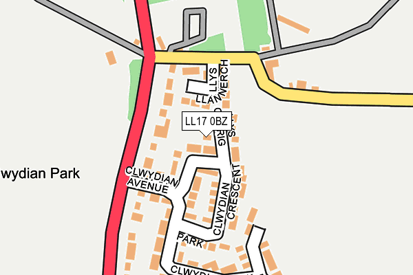
LL17 0BZ lies on Llys Cerrig in St. Asaph. LL17 0BZ is located in the Trefnant electoral ward, within the unitary authority of Denbighshire and the Welsh Parliamentary constituency of Vale of Clwyd. The Local Health Board is Betsi Cadwaladr University and the police force is North Wales. This postcode has been in use since July 1986.


GetTheData
Source: OS OpenMap – Local (Ordnance Survey)
Source: OS VectorMap District (Ordnance Survey)
Licence: Open Government Licence (requires attribution)
| Easting | 304734 |
| Northing | 371574 |
| Latitude | 53.232627 |
| Longitude | -3.428683 |
GetTheData
Source: Open Postcode Geo
Licence: Open Government Licence
| Street | Llys Cerrig |
| Town/City | St. Asaph |
| Country | Wales |
| Postcode District | LL17 |
➜ See where LL17 is on a map ➜ Where is Nant-y-Patrick? | |
GetTheData
Source: Land Registry Price Paid Data
Licence: Open Government Licence
Elevation or altitude of LL17 0BZ as distance above sea level:
| Metres | Feet | |
|---|---|---|
| Elevation | 60m | 197ft |
Elevation is measured from the approximate centre of the postcode, to the nearest point on an OS contour line from OS Terrain 50, which has contour spacing of ten vertical metres.
➜ How high above sea level am I? Find the elevation of your current position using your device's GPS.
GetTheData
Source: Open Postcode Elevation
Licence: Open Government Licence
| Ward | Trefnant |
| Constituency | Vale Of Clwyd |
GetTheData
Source: ONS Postcode Database
Licence: Open Government Licence
| Thatched Cottage (St Asaph Road) | Hafod-y-green | 103m |
| Thatched Cottage (St Asaph Road) | Hafod-y-green | 237m |
| Tweedmill Shopping Outlet (Grounds) | Hafod-y-green | 294m |
| Nant-y-patrick (St Asaph Road) | Hafod-y-green | 313m |
| Nant-y-patrick (St Asaph Road) | Hafod-y-green | 338m |
GetTheData
Source: NaPTAN
Licence: Open Government Licence
| Percentage of properties with Next Generation Access | 100.0% |
| Percentage of properties with Superfast Broadband | 100.0% |
| Percentage of properties with Ultrafast Broadband | 0.0% |
| Percentage of properties with Full Fibre Broadband | 0.0% |
Superfast Broadband is between 30Mbps and 300Mbps
Ultrafast Broadband is > 300Mbps
| Percentage of properties unable to receive 2Mbps | 0.0% |
| Percentage of properties unable to receive 5Mbps | 0.0% |
| Percentage of properties unable to receive 10Mbps | 0.0% |
| Percentage of properties unable to receive 30Mbps | 0.0% |
GetTheData
Source: Ofcom
Licence: Ofcom Terms of Use (requires attribution)
GetTheData
Source: ONS Postcode Database
Licence: Open Government Licence


➜ Get more ratings from the Food Standards Agency
GetTheData
Source: Food Standards Agency
Licence: FSA terms & conditions
| Last Collection | |||
|---|---|---|---|
| Location | Mon-Fri | Sat | Distance |
| Nant Yr Patrick | 16:15 | 08:00 | 290m |
| Eryl | 16:15 | 08:00 | 1,642m |
| Maes Heulyn | 09:00 | 11:45 | 2,496m |
GetTheData
Source: Dracos
Licence: Creative Commons Attribution-ShareAlike
The below table lists the International Territorial Level (ITL) codes (formerly Nomenclature of Territorial Units for Statistics (NUTS) codes) and Local Administrative Units (LAU) codes for LL17 0BZ:
| ITL 1 Code | Name |
|---|---|
| TLL | Wales |
| ITL 2 Code | Name |
| TLL1 | West Wales and The Valleys |
| ITL 3 Code | Name |
| TLL13 | Conwy and Denbighshire |
| LAU 1 Code | Name |
| W06000004 | Denbighshire |
GetTheData
Source: ONS Postcode Directory
Licence: Open Government Licence
The below table lists the Census Output Area (OA), Lower Layer Super Output Area (LSOA), and Middle Layer Super Output Area (MSOA) for LL17 0BZ:
| Code | Name | |
|---|---|---|
| OA | W00001327 | |
| LSOA | W01000247 | Denbighshire 010C |
| MSOA | W02000051 | Denbighshire 010 |
GetTheData
Source: ONS Postcode Directory
Licence: Open Government Licence
| LL17 0AZ | Llys Llannerch | 47m |
| LL17 0BG | Upper Denbigh Road | 79m |
| LL17 0BJ | Clwydian Park Crescent | 81m |
| LL17 0BL | Clwydian Avenue | 116m |
| LL17 0BX | Clwydian Park View | 177m |
| LL17 0BQ | Clwydian Park Avenue | 188m |
| LL17 0BN | Nant Y Patrick | 285m |
| LL17 0YA | Bron Dyffryn | 326m |
| LL17 0BF | Llys Caradog | 506m |
| LL17 0BW | Allt Goch | 508m |
GetTheData
Source: Open Postcode Geo; Land Registry Price Paid Data
Licence: Open Government Licence