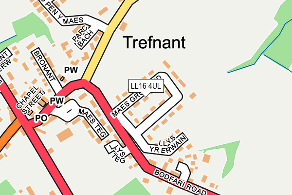
LL16 4UL lies on Maes Gruffydd Estate in Trefnant, Denbigh. LL16 4UL is located in the Trefnant electoral ward, within the unitary authority of Denbighshire and the Welsh Parliamentary constituency of Vale of Clwyd. The Local Health Board is Betsi Cadwaladr University and the police force is North Wales. This postcode has been in use since January 1980.


GetTheData
Source: OS OpenMap – Local (Ordnance Survey)
Source: OS VectorMap District (Ordnance Survey)
Licence: Open Government Licence (requires attribution)
| Easting | 305423 |
| Northing | 370716 |
| Latitude | 53.225040 |
| Longitude | -3.418109 |
GetTheData
Source: Open Postcode Geo
Licence: Open Government Licence
| Street | Maes Gruffydd Estate |
| Locality | Trefnant |
| Town/City | Denbigh |
| Country | Wales |
| Postcode District | LL16 |
➜ See where LL16 is on a map ➜ Where is Trefnant? | |
GetTheData
Source: Land Registry Price Paid Data
Licence: Open Government Licence
Elevation or altitude of LL16 4UL as distance above sea level:
| Metres | Feet | |
|---|---|---|
| Elevation | 50m | 164ft |
Elevation is measured from the approximate centre of the postcode, to the nearest point on an OS contour line from OS Terrain 50, which has contour spacing of ten vertical metres.
➜ How high above sea level am I? Find the elevation of your current position using your device's GPS.
GetTheData
Source: Open Postcode Elevation
Licence: Open Government Licence
| Ward | Trefnant |
| Constituency | Vale Of Clwyd |
GetTheData
Source: ONS Postcode Database
Licence: Open Government Licence
| Village Hall (Post Office Terrace) | Trefnant | 234m |
| Village Hall (Post Office Terrace) | Trefnant | 247m |
| College Farm (A525) | Trefnant | 488m |
| College Farm (A525) | Trefnant | 509m |
| Plas Newydd (A525) | Green | 1,007m |
GetTheData
Source: NaPTAN
Licence: Open Government Licence
| Percentage of properties with Next Generation Access | 100.0% |
| Percentage of properties with Superfast Broadband | 100.0% |
| Percentage of properties with Ultrafast Broadband | 0.0% |
| Percentage of properties with Full Fibre Broadband | 0.0% |
Superfast Broadband is between 30Mbps and 300Mbps
Ultrafast Broadband is > 300Mbps
| Median download speed | 47.2Mbps |
| Average download speed | 53.5Mbps |
| Maximum download speed | 80.00Mbps |
| Median upload speed | 10.0Mbps |
| Average upload speed | 12.6Mbps |
| Maximum upload speed | 20.00Mbps |
| Percentage of properties unable to receive 2Mbps | 0.0% |
| Percentage of properties unable to receive 5Mbps | 0.0% |
| Percentage of properties unable to receive 10Mbps | 0.0% |
| Percentage of properties unable to receive 30Mbps | 0.0% |
GetTheData
Source: Ofcom
Licence: Ofcom Terms of Use (requires attribution)
Estimated total energy consumption in LL16 4UL by fuel type, 2015.
| Consumption (kWh) | 433,720 |
|---|---|
| Meter count | 46 |
| Mean (kWh/meter) | 9,429 |
| Median (kWh/meter) | 9,805 |
| Consumption (kWh) | 142,118 |
|---|---|
| Meter count | 46 |
| Mean (kWh/meter) | 3,090 |
| Median (kWh/meter) | 2,916 |
GetTheData
Source: Postcode level gas estimates: 2015 (experimental)
Source: Postcode level electricity estimates: 2015 (experimental)
Licence: Open Government Licence
GetTheData
Source: ONS Postcode Database
Licence: Open Government Licence


➜ Get more ratings from the Food Standards Agency
GetTheData
Source: Food Standards Agency
Licence: FSA terms & conditions
| Last Collection | |||
|---|---|---|---|
| Location | Mon-Fri | Sat | Distance |
| Nant Yr Patrick | 16:15 | 08:00 | 991m |
| Maes Heulyn | 09:00 | 11:45 | 1,442m |
| Eryl | 16:15 | 08:00 | 2,740m |
GetTheData
Source: Dracos
Licence: Creative Commons Attribution-ShareAlike
The below table lists the International Territorial Level (ITL) codes (formerly Nomenclature of Territorial Units for Statistics (NUTS) codes) and Local Administrative Units (LAU) codes for LL16 4UL:
| ITL 1 Code | Name |
|---|---|
| TLL | Wales |
| ITL 2 Code | Name |
| TLL1 | West Wales and The Valleys |
| ITL 3 Code | Name |
| TLL13 | Conwy and Denbighshire |
| LAU 1 Code | Name |
| W06000004 | Denbighshire |
GetTheData
Source: ONS Postcode Directory
Licence: Open Government Licence
The below table lists the Census Output Area (OA), Lower Layer Super Output Area (LSOA), and Middle Layer Super Output Area (MSOA) for LL16 4UL:
| Code | Name | |
|---|---|---|
| OA | W00001330 | |
| LSOA | W01000247 | Denbighshire 010C |
| MSOA | W02000051 | Denbighshire 010 |
GetTheData
Source: ONS Postcode Directory
Licence: Open Government Licence
| LL16 4YA | Maes Teg | 103m |
| LL16 4UQ | Trem Y Dyffryn | 146m |
| LL16 4YE | Parc Bach | 154m |
| LL16 4UA | Bodfari Road | 175m |
| LL16 4UT | Hen Gapel | 177m |
| LL16 4UR | Railway Terrace | 203m |
| LL16 4UN | 210m | |
| LL16 5UG | 225m | |
| LL16 4UP | 226m | |
| LL16 4UY | Elwy Parc | 226m |
GetTheData
Source: Open Postcode Geo; Land Registry Price Paid Data
Licence: Open Government Licence