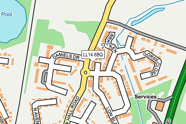
LL14 6BQ lies on Lindisfarne Close in Ruabon, Wrexham. LL14 6BQ is located in the Ruabon electoral ward, within the unitary authority of Wrexham and the Welsh Parliamentary constituency of Clwyd South. The Local Health Board is Betsi Cadwaladr University and the police force is North Wales. This postcode has been in use since December 1999.


GetTheData
Source: OS OpenMap – Local (Ordnance Survey)
Source: OS VectorMap District (Ordnance Survey)
Licence: Open Government Licence (requires attribution)
| Easting | 330666 |
| Northing | 344667 |
| Latitude | 52.994823 |
| Longitude | -3.034444 |
GetTheData
Source: Open Postcode Geo
Licence: Open Government Licence
| Street | Lindisfarne Close |
| Locality | Ruabon |
| Town/City | Wrexham |
| Country | Wales |
| Postcode District | LL14 |
➜ See where LL14 is on a map ➜ Where is Ruabon? | |
GetTheData
Source: Land Registry Price Paid Data
Licence: Open Government Licence
Elevation or altitude of LL14 6BQ as distance above sea level:
| Metres | Feet | |
|---|---|---|
| Elevation | 110m | 361ft |
Elevation is measured from the approximate centre of the postcode, to the nearest point on an OS contour line from OS Terrain 50, which has contour spacing of ten vertical metres.
➜ How high above sea level am I? Find the elevation of your current position using your device's GPS.
GetTheData
Source: Open Postcode Elevation
Licence: Open Government Licence
| Ward | Ruabon |
| Constituency | Clwyd South |
GetTheData
Source: ONS Postcode Database
Licence: Open Government Licence
2020 13 NOV £226,000 |
2017 4 AUG £195,000 |
2015 26 JUN £172,000 |
2013 2 AUG £190,000 |
2006 21 APR £198,000 |
2003 29 AUG £157,500 |
5, LINDISFARNE CLOSE, RUABON, WREXHAM, LL14 6BQ 2001 20 DEC £81,050 |
4, LINDISFARNE CLOSE, RUABON, WREXHAM, LL14 6BQ 2001 23 NOV £106,000 |
2001 26 OCT £93,500 |
2000 31 MAR £89,950 |
GetTheData
Source: HM Land Registry Price Paid Data
Licence: Contains HM Land Registry data © Crown copyright and database right 2025. This data is licensed under the Open Government Licence v3.0.
| Shellbrooke Drive (New Hall Road) | Ruabon | 63m |
| Shellbrooke Drive (New Hall Road) | Ruabon | 75m |
| London House (Daniels Drive) | Ruabon | 158m |
| Wat`s Dyke View (Albert Grove) | Ruabon | 189m |
| Wat`s Dyke View (Albert Grove) | Ruabon | 197m |
| Ruabon Station | 1km |
GetTheData
Source: NaPTAN
Licence: Open Government Licence
| Percentage of properties with Next Generation Access | 100.0% |
| Percentage of properties with Superfast Broadband | 100.0% |
| Percentage of properties with Ultrafast Broadband | 0.0% |
| Percentage of properties with Full Fibre Broadband | 0.0% |
Superfast Broadband is between 30Mbps and 300Mbps
Ultrafast Broadband is > 300Mbps
| Percentage of properties unable to receive 2Mbps | 0.0% |
| Percentage of properties unable to receive 5Mbps | 0.0% |
| Percentage of properties unable to receive 10Mbps | 0.0% |
| Percentage of properties unable to receive 30Mbps | 0.0% |
GetTheData
Source: Ofcom
Licence: Ofcom Terms of Use (requires attribution)
GetTheData
Source: ONS Postcode Database
Licence: Open Government Licence


➜ Get more ratings from the Food Standards Agency
GetTheData
Source: Food Standards Agency
Licence: FSA terms & conditions
| Last Collection | |||
|---|---|---|---|
| Location | Mon-Fri | Sat | Distance |
| Park St | 09:00 | 08:15 | 964m |
| Alwyn | 10:45 | 10:00 | 1,966m |
| Plas Isa (Rhosymedre) | 16:15 | 10:45 | 2,620m |
GetTheData
Source: Dracos
Licence: Creative Commons Attribution-ShareAlike
The below table lists the International Territorial Level (ITL) codes (formerly Nomenclature of Territorial Units for Statistics (NUTS) codes) and Local Administrative Units (LAU) codes for LL14 6BQ:
| ITL 1 Code | Name |
|---|---|
| TLL | Wales |
| ITL 2 Code | Name |
| TLL2 | East Wales |
| ITL 3 Code | Name |
| TLL23 | Flintshire and Wrexham |
| LAU 1 Code | Name |
| W06000006 | Wrexham |
GetTheData
Source: ONS Postcode Directory
Licence: Open Government Licence
The below table lists the Census Output Area (OA), Lower Layer Super Output Area (LSOA), and Middle Layer Super Output Area (MSOA) for LL14 6BQ:
| Code | Name | |
|---|---|---|
| OA | W00010034 | |
| LSOA | W01000419 | Wrexham 016D |
| MSOA | W02000093 | Wrexham 016 |
GetTheData
Source: ONS Postcode Directory
Licence: Open Government Licence
| LL14 6BW | Bedwell Close | 77m |
| LL14 6BJ | Bracken Close | 86m |
| LL14 6AY | Daniels Drive | 115m |
| LL14 6AU | Bryn Way | 115m |
| LL14 6BX | Shellbrook Drive | 137m |
| LL14 6BS | Heather Close | 153m |
| LL14 6BA | Daniels Drive | 160m |
| LL14 6AT | New Hall Road | 169m |
| LL14 6BZ | Gorse Close | 192m |
| LL14 6BP | Blackbrook Drive | 224m |
GetTheData
Source: Open Postcode Geo; Land Registry Price Paid Data
Licence: Open Government Licence