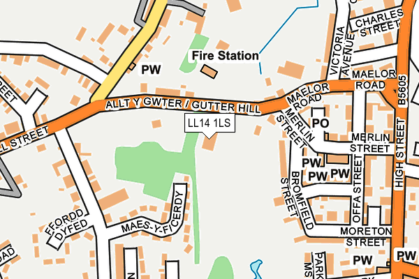
LL14 1LS lies on Gutter Hill in Rhosllanerchrugog, Wrexham. LL14 1LS is located in the Pant and Johnstown electoral ward, within the unitary authority of Wrexham and the Welsh Parliamentary constituency of Clwyd South. The Local Health Board is Betsi Cadwaladr University and the police force is North Wales. This postcode has been in use since January 2020.


GetTheData
Source: OS OpenMap – Local (Ordnance Survey)
Source: OS VectorMap District (Ordnance Survey)
Licence: Open Government Licence (requires attribution)
| Easting | 329752 |
| Northing | 346316 |
| Latitude | 53.009540 |
| Longitude | -3.048418 |
GetTheData
Source: Open Postcode Geo
Licence: Open Government Licence
| Street | Gutter Hill |
| Locality | Rhosllanerchrugog |
| Town/City | Wrexham |
| Country | Wales |
| Postcode District | LL14 |
➜ See where LL14 is on a map ➜ Where is Rhosllannerchrugog? | |
GetTheData
Source: Land Registry Price Paid Data
Licence: Open Government Licence
Elevation or altitude of LL14 1LS as distance above sea level:
| Metres | Feet | |
|---|---|---|
| Elevation | 140m | 459ft |
Elevation is measured from the approximate centre of the postcode, to the nearest point on an OS contour line from OS Terrain 50, which has contour spacing of ten vertical metres.
➜ How high above sea level am I? Find the elevation of your current position using your device's GPS.
GetTheData
Source: Open Postcode Elevation
Licence: Open Government Licence
| Ward | Pant And Johnstown |
| Constituency | Clwyd South |
GetTheData
Source: ONS Postcode Database
Licence: Open Government Licence
MAES HEULOG, GUTTER HILL, RHOSLLANERCHRUGOG, WREXHAM, LL14 1LS 2012 7 DEC £84,000 |
➜ Rhosllannerchrugog house prices
GetTheData
Source: HM Land Registry Price Paid Data
Licence: Contains HM Land Registry data © Crown copyright and database right 2025. This data is licensed under the Open Government Licence v3.0.
| Gardden Road Surgery (Gardden Road) | Rhosllanerchrugog | 130m |
| Gardden Road Surgery (Gardden Road) | Rhosllanerchrugog | 136m |
| War Memorial (Hill Street) | Rhosllanerchrugog | 192m |
| Memorial (Hill Street) | Rhosllanerchrugog | 214m |
| Ffordd Powys (Gardden Road) | Pant | 257m |
| Ruabon Station | 2.5km |
| Wrexham Central Station | 5.3km |
| Wrexham General Station | 5.5km |
GetTheData
Source: NaPTAN
Licence: Open Government Licence
GetTheData
Source: ONS Postcode Database
Licence: Open Government Licence


➜ Get more ratings from the Food Standards Agency
GetTheData
Source: Food Standards Agency
Licence: FSA terms & conditions
| Last Collection | |||
|---|---|---|---|
| Location | Mon-Fri | Sat | Distance |
| Park St | 09:00 | 08:15 | 2,615m |
| Alwyn | 10:45 | 10:00 | 2,977m |
| Plas Isa (Rhosymedre) | 16:15 | 10:45 | 3,600m |
GetTheData
Source: Dracos
Licence: Creative Commons Attribution-ShareAlike
The below table lists the International Territorial Level (ITL) codes (formerly Nomenclature of Territorial Units for Statistics (NUTS) codes) and Local Administrative Units (LAU) codes for LL14 1LS:
| ITL 1 Code | Name |
|---|---|
| TLL | Wales |
| ITL 2 Code | Name |
| TLL2 | East Wales |
| ITL 3 Code | Name |
| TLL23 | Flintshire and Wrexham |
| LAU 1 Code | Name |
| W06000006 | Wrexham |
GetTheData
Source: ONS Postcode Directory
Licence: Open Government Licence
The below table lists the Census Output Area (OA), Lower Layer Super Output Area (LSOA), and Middle Layer Super Output Area (MSOA) for LL14 1LS:
| Code | Name | |
|---|---|---|
| OA | W00002155 | |
| LSOA | W01000405 | Wrexham 015B |
| MSOA | W02000092 | Wrexham 015 |
GetTheData
Source: ONS Postcode Directory
Licence: Open Government Licence
| LL14 1LY | Hillside Terrace | 44m |
| LL14 2EN | Gardden Road | 128m |
| LL14 1SR | Hyfrydle | 132m |
| LL14 1SD | Chapel Street | 143m |
| LL14 1TD | Park View | 145m |
| LL14 1LT | Gutter Hill | 145m |
| LL14 2ER | Bryn Dedwydd | 147m |
| LL14 1SP | Furnace Bank | 161m |
| LL14 1SF | Chapel Terrace | 164m |
| LL14 1LP | Hill Street | 169m |
GetTheData
Source: Open Postcode Geo; Land Registry Price Paid Data
Licence: Open Government Licence