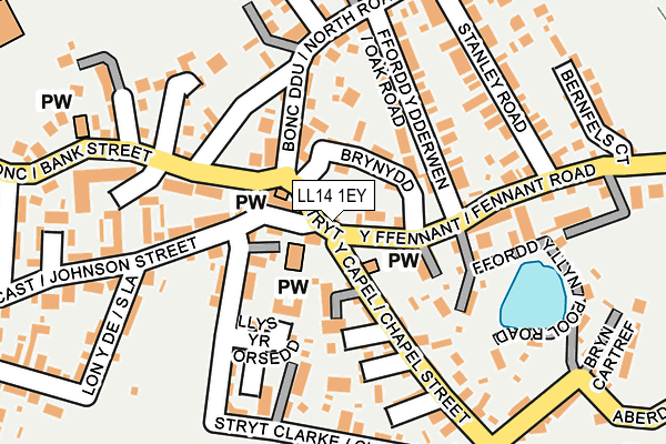
LL14 1EY lies on Bank Street in Ponciau, Wrexham. LL14 1EY is located in the Ponciau electoral ward, within the unitary authority of Wrexham and the Welsh Parliamentary constituency of Clwyd South. The Local Health Board is Betsi Cadwaladr University and the police force is North Wales. This postcode has been in use since January 1980.


GetTheData
Source: OS OpenMap – Local (Ordnance Survey)
Source: OS VectorMap District (Ordnance Survey)
Licence: Open Government Licence (requires attribution)
| Easting | 329596 |
| Northing | 346801 |
| Latitude | 53.013879 |
| Longitude | -3.050848 |
GetTheData
Source: Open Postcode Geo
Licence: Open Government Licence
| Street | Bank Street |
| Locality | Ponciau |
| Town/City | Wrexham |
| Country | Wales |
| Postcode District | LL14 |
➜ See where LL14 is on a map ➜ Where is Rhosllannerchrugog? | |
GetTheData
Source: Land Registry Price Paid Data
Licence: Open Government Licence
Elevation or altitude of LL14 1EY as distance above sea level:
| Metres | Feet | |
|---|---|---|
| Elevation | 160m | 525ft |
Elevation is measured from the approximate centre of the postcode, to the nearest point on an OS contour line from OS Terrain 50, which has contour spacing of ten vertical metres.
➜ How high above sea level am I? Find the elevation of your current position using your device's GPS.
GetTheData
Source: Open Postcode Elevation
Licence: Open Government Licence
| Ward | Ponciau |
| Constituency | Clwyd South |
GetTheData
Source: ONS Postcode Database
Licence: Open Government Licence
| Hand Lane (Bank Street) | Ponciau | 83m |
| Royal Oak (Fennant Road) | Ponciau | 90m |
| Royal Oak (Fennant Road) | Ponciau | 99m |
| Hand Lane (Bank Street) | Ponciau | 101m |
| Bernfels Court (Fennant Road) | Ponciau | 292m |
| Ruabon Station | 3km |
| Wrexham Central Station | 5km |
| Wrexham General Station | 5.2km |
GetTheData
Source: NaPTAN
Licence: Open Government Licence
| Percentage of properties with Next Generation Access | 100.0% |
| Percentage of properties with Superfast Broadband | 0.0% |
| Percentage of properties with Ultrafast Broadband | 0.0% |
| Percentage of properties with Full Fibre Broadband | 0.0% |
Superfast Broadband is between 30Mbps and 300Mbps
Ultrafast Broadband is > 300Mbps
| Percentage of properties unable to receive 2Mbps | 0.0% |
| Percentage of properties unable to receive 5Mbps | 0.0% |
| Percentage of properties unable to receive 10Mbps | 0.0% |
| Percentage of properties unable to receive 30Mbps | 100.0% |
GetTheData
Source: Ofcom
Licence: Ofcom Terms of Use (requires attribution)
GetTheData
Source: ONS Postcode Database
Licence: Open Government Licence


➜ Get more ratings from the Food Standards Agency
GetTheData
Source: Food Standards Agency
Licence: FSA terms & conditions
| Last Collection | |||
|---|---|---|---|
| Location | Mon-Fri | Sat | Distance |
| Park St | 09:00 | 08:15 | 3,123m |
| Alwyn | 10:45 | 10:00 | 3,430m |
| Plas Isa (Rhosymedre) | 16:15 | 10:45 | 4,034m |
GetTheData
Source: Dracos
Licence: Creative Commons Attribution-ShareAlike
The below table lists the International Territorial Level (ITL) codes (formerly Nomenclature of Territorial Units for Statistics (NUTS) codes) and Local Administrative Units (LAU) codes for LL14 1EY:
| ITL 1 Code | Name |
|---|---|
| TLL | Wales |
| ITL 2 Code | Name |
| TLL2 | East Wales |
| ITL 3 Code | Name |
| TLL23 | Flintshire and Wrexham |
| LAU 1 Code | Name |
| W06000006 | Wrexham |
GetTheData
Source: ONS Postcode Directory
Licence: Open Government Licence
The below table lists the Census Output Area (OA), Lower Layer Super Output Area (LSOA), and Middle Layer Super Output Area (MSOA) for LL14 1EY:
| Code | Name | |
|---|---|---|
| OA | W00002192 | |
| LSOA | W01000411 | Wrexham 015C |
| MSOA | W02000092 | Wrexham 015 |
GetTheData
Source: ONS Postcode Directory
Licence: Open Government Licence
| LL14 1EP | Bank Street | 9m |
| LL14 1EU | Bank Terrace | 25m |
| LL14 1SB | Emlyn Terrace | 62m |
| LL14 1HX | Maes Grug | 75m |
| LL14 1HA | Brynydd | 81m |
| LL14 1RP | School Lane | 89m |
| LL14 1HU | California Terrace | 96m |
| LL14 1RW | Johnson Street | 98m |
| LL14 1HY | Williams Terrace | 98m |
| LL14 1SA | Castle Street | 101m |
GetTheData
Source: Open Postcode Geo; Land Registry Price Paid Data
Licence: Open Government Licence