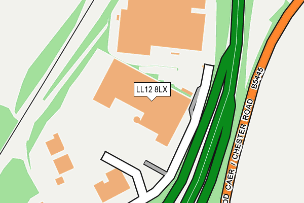
LL12 8LX is located in the Gwersyllt South electoral ward, within the unitary authority of Wrexham and the Welsh Parliamentary constituency of Wrexham. The Local Health Board is Betsi Cadwaladr University and the police force is North Wales. This postcode has been in use since January 1993.


GetTheData
Source: OS OpenMap – Local (Ordnance Survey)
Source: OS VectorMap District (Ordnance Survey)
Licence: Open Government Licence (requires attribution)
| Easting | 333872 |
| Northing | 353655 |
| Latitude | 53.076028 |
| Longitude | -2.988533 |
GetTheData
Source: Open Postcode Geo
Licence: Open Government Licence
| Country | Wales |
| Postcode District | LL12 |
➜ See where LL12 is on a map | |
GetTheData
Source: Land Registry Price Paid Data
Licence: Open Government Licence
Elevation or altitude of LL12 8LX as distance above sea level:
| Metres | Feet | |
|---|---|---|
| Elevation | 80m | 262ft |
Elevation is measured from the approximate centre of the postcode, to the nearest point on an OS contour line from OS Terrain 50, which has contour spacing of ten vertical metres.
➜ How high above sea level am I? Find the elevation of your current position using your device's GPS.
GetTheData
Source: Open Postcode Elevation
Licence: Open Government Licence
| Ward | Gwersyllt South |
| Constituency | Wrexham |
GetTheData
Source: ONS Postcode Database
Licence: Open Government Licence
| Gresford Roundabout (Chester Road) | Garden Village | 286m |
| Gresford Roundabout (Chester Road) | Garden Village | 291m |
| Gresford Heath (Bluebell Lane) | Pandy Farm | 499m |
| Gresford Heath (Bluebell Lane) | Garden Village | 515m |
| Beeches Hotel (Chester Road) | Gresford | 574m |
| Gwersyllt Station | 2km |
| Wrexham General Station | 3km |
| Wrexham Central Station | 3.4km |
GetTheData
Source: NaPTAN
Licence: Open Government Licence
| Median download speed | 24.2Mbps |
| Average download speed | 22.5Mbps |
| Maximum download speed | 40.00Mbps |
| Median upload speed | 1.6Mbps |
| Average upload speed | 2.2Mbps |
| Maximum upload speed | 5.30Mbps |
GetTheData
Source: Ofcom
Licence: Ofcom Terms of Use (requires attribution)
GetTheData
Source: ONS Postcode Database
Licence: Open Government Licence


➜ Get more ratings from the Food Standards Agency
GetTheData
Source: Food Standards Agency
Licence: FSA terms & conditions
| Last Collection | |||
|---|---|---|---|
| Location | Mon-Fri | Sat | Distance |
| Firtree Road | 11:30 | 10:45 | 1,096m |
| Rhosrobin Post Office | 17:15 | 10:30 | 1,325m |
| Old Rhosrobin | 16:00 | 07:30 | 1,336m |
GetTheData
Source: Dracos
Licence: Creative Commons Attribution-ShareAlike
The below table lists the International Territorial Level (ITL) codes (formerly Nomenclature of Territorial Units for Statistics (NUTS) codes) and Local Administrative Units (LAU) codes for LL12 8LX:
| ITL 1 Code | Name |
|---|---|
| TLL | Wales |
| ITL 2 Code | Name |
| TLL2 | East Wales |
| ITL 3 Code | Name |
| TLL23 | Flintshire and Wrexham |
| LAU 1 Code | Name |
| W06000006 | Wrexham |
GetTheData
Source: ONS Postcode Directory
Licence: Open Government Licence
The below table lists the Census Output Area (OA), Lower Layer Super Output Area (LSOA), and Middle Layer Super Output Area (MSOA) for LL12 8LX:
| Code | Name | |
|---|---|---|
| OA | W00001980 | |
| LSOA | W01000370 | Wrexham 020G |
| MSOA | W02000420 | Wrexham 020 |
GetTheData
Source: ONS Postcode Directory
Licence: Open Government Licence
| LL12 8EJ | Avondale Crescent | 365m |
| LL12 8PQ | Arley Road | 415m |
| LL12 8EZ | Chatsworth Gardens | 467m |
| LL12 8LQ | Adderley Bank | 510m |
| LL12 8DU | Chester Road | 532m |
| LL12 8PZ | Westbury Drive | 548m |
| LL12 8JY | Cwm Eithin | 553m |
| LL12 8JE | Ffordd Garmonydd | 562m |
| LL12 8EQ | Bridgewater Mews | 571m |
| LL11 2UH | Blue Bell Estate | 587m |
GetTheData
Source: Open Postcode Geo; Land Registry Price Paid Data
Licence: Open Government Licence