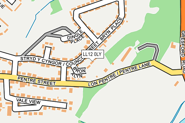
LL12 0LY is located in the Llay electoral ward, within the unitary authority of Wrexham and the Welsh Parliamentary constituency of Wrexham. The Local Health Board is Betsi Cadwaladr University and the police force is North Wales. This postcode has been in use since January 1980.


GetTheData
Source: OS OpenMap – Local (Ordnance Survey)
Source: OS VectorMap District (Ordnance Survey)
Licence: Open Government Licence (requires attribution)
| Easting | 333785 |
| Northing | 355260 |
| Latitude | 53.090426 |
| Longitude | -2.990162 |
GetTheData
Source: Open Postcode Geo
Licence: Open Government Licence
| Country | Wales |
| Postcode District | LL12 |
➜ See where LL12 is on a map ➜ Where is Llay? | |
GetTheData
Source: Land Registry Price Paid Data
Licence: Open Government Licence
Elevation or altitude of LL12 0LY as distance above sea level:
| Metres | Feet | |
|---|---|---|
| Elevation | 70m | 230ft |
Elevation is measured from the approximate centre of the postcode, to the nearest point on an OS contour line from OS Terrain 50, which has contour spacing of ten vertical metres.
➜ How high above sea level am I? Find the elevation of your current position using your device's GPS.
GetTheData
Source: Open Postcode Elevation
Licence: Open Government Licence
| Ward | Llay |
| Constituency | Wrexham |
GetTheData
Source: ONS Postcode Database
Licence: Open Government Licence
| Platt's Corner (Penybryn) | Llay | 93m |
| Penbryn | Llay | 106m |
| Fish & Chip Shop (Tenth Avenue) | Llay | 261m |
| St David`s Crescent (Pentre Street) | Llay | 336m |
| St David`s Crescent (Pentre Street) | Llay | 336m |
| Gwersyllt Station | 2.7km |
| Cefn-y-Bedd Station | 2.9km |
| Caergwrle Station | 3.5km |
GetTheData
Source: NaPTAN
Licence: Open Government Licence
| Percentage of properties with Next Generation Access | 100.0% |
| Percentage of properties with Superfast Broadband | 100.0% |
| Percentage of properties with Ultrafast Broadband | 0.0% |
| Percentage of properties with Full Fibre Broadband | 0.0% |
Superfast Broadband is between 30Mbps and 300Mbps
Ultrafast Broadband is > 300Mbps
| Median download speed | 37.2Mbps |
| Average download speed | 32.2Mbps |
| Maximum download speed | 42.76Mbps |
| Median upload speed | 6.2Mbps |
| Average upload speed | 5.8Mbps |
| Maximum upload speed | 8.44Mbps |
| Percentage of properties unable to receive 2Mbps | 0.0% |
| Percentage of properties unable to receive 5Mbps | 0.0% |
| Percentage of properties unable to receive 10Mbps | 0.0% |
| Percentage of properties unable to receive 30Mbps | 0.0% |
GetTheData
Source: Ofcom
Licence: Ofcom Terms of Use (requires attribution)
Estimated total energy consumption in LL12 0LY by fuel type, 2015.
| Consumption (kWh) | 48,780 |
|---|---|
| Meter count | 6 |
| Mean (kWh/meter) | 8,130 |
| Median (kWh/meter) | 7,474 |
| Consumption (kWh) | 9,654 |
|---|---|
| Meter count | 6 |
| Mean (kWh/meter) | 1,609 |
| Median (kWh/meter) | 1,662 |
GetTheData
Source: Postcode level gas estimates: 2015 (experimental)
Source: Postcode level electricity estimates: 2015 (experimental)
Licence: Open Government Licence
GetTheData
Source: ONS Postcode Database
Licence: Open Government Licence


➜ Get more ratings from the Food Standards Agency
GetTheData
Source: Food Standards Agency
Licence: FSA terms & conditions
| Last Collection | |||
|---|---|---|---|
| Location | Mon-Fri | Sat | Distance |
| Ninth Avenue | 12:00 | 11:15 | 523m |
| Singrett Hill | 16:15 | 09:45 | 595m |
| Llay Post Office | 16:30 | 10:45 | 693m |
GetTheData
Source: Dracos
Licence: Creative Commons Attribution-ShareAlike
The below table lists the International Territorial Level (ITL) codes (formerly Nomenclature of Territorial Units for Statistics (NUTS) codes) and Local Administrative Units (LAU) codes for LL12 0LY:
| ITL 1 Code | Name |
|---|---|
| TLL | Wales |
| ITL 2 Code | Name |
| TLL2 | East Wales |
| ITL 3 Code | Name |
| TLL23 | Flintshire and Wrexham |
| LAU 1 Code | Name |
| W06000006 | Wrexham |
GetTheData
Source: ONS Postcode Directory
Licence: Open Government Licence
The below table lists the Census Output Area (OA), Lower Layer Super Output Area (LSOA), and Middle Layer Super Output Area (MSOA) for LL12 0LY:
| Code | Name | |
|---|---|---|
| OA | W00002082 | |
| LSOA | W01000392 | Wrexham 003E |
| MSOA | W02000080 | Wrexham 003 |
GetTheData
Source: ONS Postcode Directory
Licence: Open Government Licence
| LL12 0LW | Council Street | 93m |
| LL12 8RN | 105m | |
| LL12 0LS | Bryn Place | 134m |
| LL12 0LR | Victory Place | 149m |
| LL12 0NF | Pentre Street | 155m |
| LL12 0LT | Bryn Place | 165m |
| LL12 0LP | Council Street | 192m |
| LL12 0NH | Vale View Estate | 222m |
| LL12 0LN | New House Avenue | 315m |
| LL12 0ND | Pentre Street | 328m |
GetTheData
Source: Open Postcode Geo; Land Registry Price Paid Data
Licence: Open Government Licence