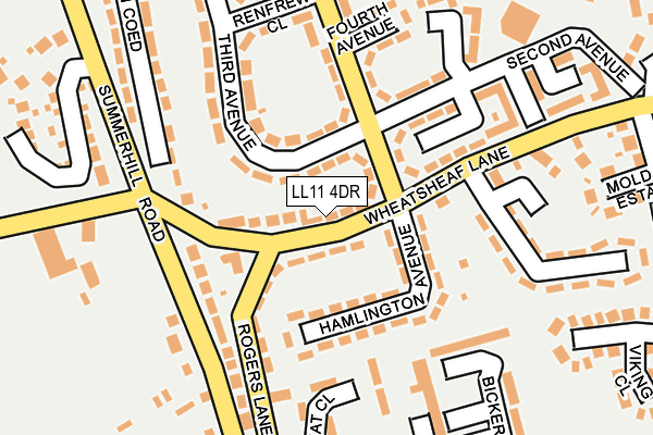
LL11 4DR lies on Wheatsheaf Lane in Gwersyllt, Wrexham. LL11 4DR is located in the Gwersyllt West electoral ward, within the unitary authority of Wrexham and the Welsh Parliamentary constituency of Wrexham. The Local Health Board is Betsi Cadwaladr University and the police force is North Wales. This postcode has been in use since January 1980.


GetTheData
Source: OS OpenMap – Local (Ordnance Survey)
Source: OS VectorMap District (Ordnance Survey)
Licence: Open Government Licence (requires attribution)
| Easting | 331446 |
| Northing | 353068 |
| Latitude | 53.070429 |
| Longitude | -3.024614 |
GetTheData
Source: Open Postcode Geo
Licence: Open Government Licence
| Street | Wheatsheaf Lane |
| Locality | Gwersyllt |
| Town/City | Wrexham |
| Country | Wales |
| Postcode District | LL11 |
➜ See where LL11 is on a map ➜ Where is Gwersyllt? | |
GetTheData
Source: Land Registry Price Paid Data
Licence: Open Government Licence
Elevation or altitude of LL11 4DR as distance above sea level:
| Metres | Feet | |
|---|---|---|
| Elevation | 110m | 361ft |
Elevation is measured from the approximate centre of the postcode, to the nearest point on an OS contour line from OS Terrain 50, which has contour spacing of ten vertical metres.
➜ How high above sea level am I? Find the elevation of your current position using your device's GPS.
GetTheData
Source: Open Postcode Elevation
Licence: Open Government Licence
| Ward | Gwersyllt West |
| Constituency | Wrexham |
GetTheData
Source: ONS Postcode Database
Licence: Open Government Licence
| Elm Villa (Wheatsheaf Lane) | Summer Hill | 112m |
| Hazel Avenue (Wheatsheaf Lane) | Summer Hill | 139m |
| Fourth Avenue (First Avenue) | Summer Hill | 149m |
| Hazel Avenue (Wheatsheaf Lane) | Summer Hill | 171m |
| Chestnut Court (Summerhill Road) | Summer Hill | 195m |
| Gwersyllt Station | 0.5km |
| Wrexham General Station | 2.7km |
| Cefn-y-Bedd Station | 3.2km |
GetTheData
Source: NaPTAN
Licence: Open Government Licence
| Percentage of properties with Next Generation Access | 100.0% |
| Percentage of properties with Superfast Broadband | 100.0% |
| Percentage of properties with Ultrafast Broadband | 0.0% |
| Percentage of properties with Full Fibre Broadband | 0.0% |
Superfast Broadband is between 30Mbps and 300Mbps
Ultrafast Broadband is > 300Mbps
| Median download speed | 40.0Mbps |
| Average download speed | 41.7Mbps |
| Maximum download speed | 74.14Mbps |
| Median upload speed | 10.0Mbps |
| Average upload speed | 11.4Mbps |
| Maximum upload speed | 20.00Mbps |
| Percentage of properties unable to receive 2Mbps | 0.0% |
| Percentage of properties unable to receive 5Mbps | 0.0% |
| Percentage of properties unable to receive 10Mbps | 0.0% |
| Percentage of properties unable to receive 30Mbps | 0.0% |
GetTheData
Source: Ofcom
Licence: Ofcom Terms of Use (requires attribution)
Estimated total energy consumption in LL11 4DR by fuel type, 2015.
| Consumption (kWh) | 199,107 |
|---|---|
| Meter count | 21 |
| Mean (kWh/meter) | 9,481 |
| Median (kWh/meter) | 9,060 |
| Consumption (kWh) | 65,835 |
|---|---|
| Meter count | 19 |
| Mean (kWh/meter) | 3,465 |
| Median (kWh/meter) | 3,413 |
GetTheData
Source: Postcode level gas estimates: 2015 (experimental)
Source: Postcode level electricity estimates: 2015 (experimental)
Licence: Open Government Licence
GetTheData
Source: ONS Postcode Database
Licence: Open Government Licence


➜ Get more ratings from the Food Standards Agency
GetTheData
Source: Food Standards Agency
Licence: FSA terms & conditions
| Last Collection | |||
|---|---|---|---|
| Location | Mon-Fri | Sat | Distance |
| Pendine Way | 09:30 | 08:45 | 331m |
| Coed Efa | 12:15 | 11:30 | 516m |
| Gwersyllt Post Office | 17:00 | 10:30 | 523m |
GetTheData
Source: Dracos
Licence: Creative Commons Attribution-ShareAlike
The below table lists the International Territorial Level (ITL) codes (formerly Nomenclature of Territorial Units for Statistics (NUTS) codes) and Local Administrative Units (LAU) codes for LL11 4DR:
| ITL 1 Code | Name |
|---|---|
| TLL | Wales |
| ITL 2 Code | Name |
| TLL2 | East Wales |
| ITL 3 Code | Name |
| TLL23 | Flintshire and Wrexham |
| LAU 1 Code | Name |
| W06000006 | Wrexham |
GetTheData
Source: ONS Postcode Directory
Licence: Open Government Licence
The below table lists the Census Output Area (OA), Lower Layer Super Output Area (LSOA), and Middle Layer Super Output Area (MSOA) for LL11 4DR:
| Code | Name | |
|---|---|---|
| OA | W00002023 | |
| LSOA | W01000379 | Wrexham 004C |
| MSOA | W02000081 | Wrexham 004 |
GetTheData
Source: ONS Postcode Directory
Licence: Open Government Licence
| LL11 4SF | Wheatsheaf Lane | 68m |
| LL11 4DY | Hamlington Avenue | 83m |
| LL11 4EG | First Avenue | 88m |
| LL11 4DP | Rogers Lane | 103m |
| LL11 4SW | Summerhill Road | 139m |
| LL11 4SG | Rogers Lane | 144m |
| LL11 4EF | Third Avenue | 154m |
| LL11 4EH | First Avenue | 166m |
| LL11 4ED | Second Avenue | 174m |
| LL11 4QT | Brambles Mews | 179m |
GetTheData
Source: Open Postcode Geo; Land Registry Price Paid Data
Licence: Open Government Licence