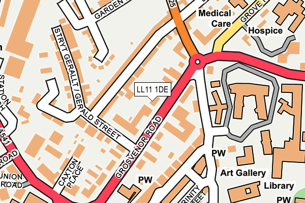
LL11 1DE is located in the Grosvenor electoral ward, within the unitary authority of Wrexham and the Welsh Parliamentary constituency of Wrexham. The Local Health Board is Betsi Cadwaladr University and the police force is North Wales. This postcode has been in use since January 1980.


GetTheData
Source: OS OpenMap – Local (Ordnance Survey)
Source: OS VectorMap District (Ordnance Survey)
Licence: Open Government Licence (requires attribution)
| Easting | 333291 |
| Northing | 350739 |
| Latitude | 53.049731 |
| Longitude | -2.996598 |
GetTheData
Source: Open Postcode Geo
Licence: Open Government Licence
| Country | Wales |
| Postcode District | LL11 |
➜ See where LL11 is on a map ➜ Where is Wrexham? | |
GetTheData
Source: Land Registry Price Paid Data
Licence: Open Government Licence
Elevation or altitude of LL11 1DE as distance above sea level:
| Metres | Feet | |
|---|---|---|
| Elevation | 90m | 295ft |
Elevation is measured from the approximate centre of the postcode, to the nearest point on an OS contour line from OS Terrain 50, which has contour spacing of ten vertical metres.
➜ How high above sea level am I? Find the elevation of your current position using your device's GPS.
GetTheData
Source: Open Postcode Elevation
Licence: Open Government Licence
| Ward | Grosvenor |
| Constituency | Wrexham |
GetTheData
Source: ONS Postcode Database
Licence: Open Government Licence
| Carlton Grange (Rhosddu Road) | Rhosddu | 132m |
| Carlton Grange (Rhosddu Road) | Rhosddu | 137m |
| Yale College (Grove Park Road) | Rhosddu | 179m |
| Post Office (Rhosddu Road) | Rhosddu | 216m |
| Yale College Flyover (A5152) | Rhosddu | 221m |
| Wrexham General Station | 0.4km |
| Wrexham Central Station | 0.4km |
| Gwersyllt Station | 2.9km |
GetTheData
Source: NaPTAN
Licence: Open Government Licence
GetTheData
Source: ONS Postcode Database
Licence: Open Government Licence


➜ Get more ratings from the Food Standards Agency
GetTheData
Source: Food Standards Agency
Licence: FSA terms & conditions
| Last Collection | |||
|---|---|---|---|
| Location | Mon-Fri | Sat | Distance |
| Gerald Street Rhosddu | 17:00 | 11:30 | 125m |
| Wrexham Delivery Office | 18:30 | 13:30 | 276m |
| Lord Street | 17:30 | 12:30 | 314m |
GetTheData
Source: Dracos
Licence: Creative Commons Attribution-ShareAlike
The below table lists the International Territorial Level (ITL) codes (formerly Nomenclature of Territorial Units for Statistics (NUTS) codes) and Local Administrative Units (LAU) codes for LL11 1DE:
| ITL 1 Code | Name |
|---|---|
| TLL | Wales |
| ITL 2 Code | Name |
| TLL2 | East Wales |
| ITL 3 Code | Name |
| TLL23 | Flintshire and Wrexham |
| LAU 1 Code | Name |
| W06000006 | Wrexham |
GetTheData
Source: ONS Postcode Directory
Licence: Open Government Licence
The below table lists the Census Output Area (OA), Lower Layer Super Output Area (LSOA), and Middle Layer Super Output Area (MSOA) for LL11 1DE:
| Code | Name | |
|---|---|---|
| OA | W00001986 | |
| LSOA | W01000372 | Wrexham 008C |
| MSOA | W02000085 | Wrexham 008 |
GetTheData
Source: ONS Postcode Directory
Licence: Open Government Licence
| LL11 1BT | Grosvenor Road | 50m |
| LL11 2LW | Vernon Street | 65m |
| LL11 2LN | Vernon Street | 93m |
| LL11 1HR | King Street | 125m |
| LL11 1BU | Grosvenor Road | 126m |
| LL11 1LA | King Street | 126m |
| LL11 1BS | Grosvenor Road | 128m |
| LL11 1EH | Gerald Street | 137m |
| LL11 1EP | Carlton Grange | 162m |
| LL12 7AA | Grove Park Road | 166m |
GetTheData
Source: Open Postcode Geo; Land Registry Price Paid Data
Licence: Open Government Licence