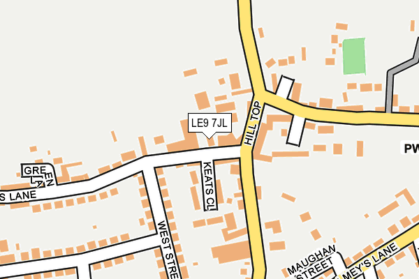
LE9 7JL lies on Keats Lane in Earl Shilton, Leicester. LE9 7JL is located in the Earl Shilton electoral ward, within the local authority district of Hinckley and Bosworth and the English Parliamentary constituency of Bosworth. The Sub Integrated Care Board (ICB) Location is NHS Leicester, Leicestershire and Rutland ICB - 04V and the police force is Leicestershire. This postcode has been in use since December 2000.


GetTheData
Source: OS OpenMap – Local (Ordnance Survey)
Source: OS VectorMap District (Ordnance Survey)
Licence: Open Government Licence (requires attribution)
| Easting | 446791 |
| Northing | 298211 |
| Latitude | 52.579706 |
| Longitude | -1.310911 |
GetTheData
Source: Open Postcode Geo
Licence: Open Government Licence
| Street | Keats Lane |
| Locality | Earl Shilton |
| Town/City | Leicester |
| Country | England |
| Postcode District | LE9 |
➜ See where LE9 is on a map ➜ Where is Earl Shilton? | |
GetTheData
Source: Land Registry Price Paid Data
Licence: Open Government Licence
Elevation or altitude of LE9 7JL as distance above sea level:
| Metres | Feet | |
|---|---|---|
| Elevation | 120m | 394ft |
Elevation is measured from the approximate centre of the postcode, to the nearest point on an OS contour line from OS Terrain 50, which has contour spacing of ten vertical metres.
➜ How high above sea level am I? Find the elevation of your current position using your device's GPS.
GetTheData
Source: Open Postcode Elevation
Licence: Open Government Licence
| Ward | Earl Shilton |
| Constituency | Bosworth |
GetTheData
Source: ONS Postcode Database
Licence: Open Government Licence
| Keats Lane (High Street) | Earl Shilton | 86m |
| Keats Lane (High Street) | Earl Shilton | 154m |
| The Beeches (Church Street) | Earl Shilton | 166m |
| Almeys Lane (High Street) | Earl Shilton | 297m |
| Park Close (Park Road) | Earl Shilton | 337m |
GetTheData
Source: NaPTAN
Licence: Open Government Licence
GetTheData
Source: ONS Postcode Database
Licence: Open Government Licence


➜ Get more ratings from the Food Standards Agency
GetTheData
Source: Food Standards Agency
Licence: FSA terms & conditions
| Last Collection | |||
|---|---|---|---|
| Location | Mon-Fri | Sat | Distance |
| Doctors Fields | 17:30 | 09:15 | 1,405m |
| Shentons Oak | 17:45 | 11:30 | 4,501m |
| Barwell Lane | 17:45 | 11:30 | 4,519m |
GetTheData
Source: Dracos
Licence: Creative Commons Attribution-ShareAlike
The below table lists the International Territorial Level (ITL) codes (formerly Nomenclature of Territorial Units for Statistics (NUTS) codes) and Local Administrative Units (LAU) codes for LE9 7JL:
| ITL 1 Code | Name |
|---|---|
| TLF | East Midlands (England) |
| ITL 2 Code | Name |
| TLF2 | Leicestershire, Rutland and Northamptonshire |
| ITL 3 Code | Name |
| TLF22 | Leicestershire CC and Rutland |
| LAU 1 Code | Name |
| E07000132 | Hinckley and Bosworth |
GetTheData
Source: ONS Postcode Directory
Licence: Open Government Licence
The below table lists the Census Output Area (OA), Lower Layer Super Output Area (LSOA), and Middle Layer Super Output Area (MSOA) for LE9 7JL:
| Code | Name | |
|---|---|---|
| OA | E00131140 | |
| LSOA | E01025843 | Hinckley and Bosworth 006E |
| MSOA | E02005382 | Hinckley and Bosworth 006 |
GetTheData
Source: ONS Postcode Directory
Licence: Open Government Licence
| LE9 7DQ | Keats Lane | 35m |
| LE9 7DP | Hill Top | 74m |
| LE9 7DU | Keats Close | 98m |
| LE9 7EL | West Street | 102m |
| LE9 7DD | The Beeches | 115m |
| LE9 7EQ | Clearview Crescent | 153m |
| LE9 7ES | Castle Close | 182m |
| LE9 7DG | High Street | 195m |
| LE9 7EJ | West Street | 212m |
| LE9 7EH | Grewcocks Place | 222m |
GetTheData
Source: Open Postcode Geo; Land Registry Price Paid Data
Licence: Open Government Licence