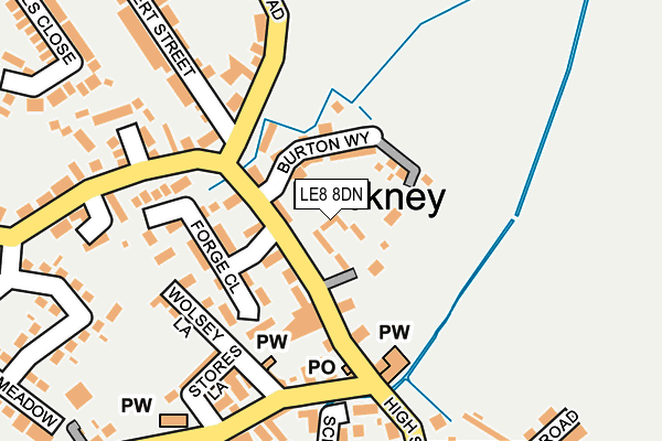
LE8 8DN lies on High Street in Fleckney, Leicester. LE8 8DN is located in the Fleckney electoral ward, within the local authority district of Harborough and the English Parliamentary constituency of Harborough. The Sub Integrated Care Board (ICB) Location is NHS Leicester, Leicestershire and Rutland ICB - 03W and the police force is Leicestershire. This postcode has been in use since May 2005.


GetTheData
Source: OS OpenMap – Local (Ordnance Survey)
Source: OS VectorMap District (Ordnance Survey)
Licence: Open Government Licence (requires attribution)
| Easting | 464892 |
| Northing | 293617 |
| Latitude | 52.536558 |
| Longitude | -1.044716 |
GetTheData
Source: Open Postcode Geo
Licence: Open Government Licence
| Street | High Street |
| Locality | Fleckney |
| Town/City | Leicester |
| Country | England |
| Postcode District | LE8 |
➜ See where LE8 is on a map ➜ Where is Fleckney? | |
GetTheData
Source: Land Registry Price Paid Data
Licence: Open Government Licence
Elevation or altitude of LE8 8DN as distance above sea level:
| Metres | Feet | |
|---|---|---|
| Elevation | 110m | 361ft |
Elevation is measured from the approximate centre of the postcode, to the nearest point on an OS contour line from OS Terrain 50, which has contour spacing of ten vertical metres.
➜ How high above sea level am I? Find the elevation of your current position using your device's GPS.
GetTheData
Source: Open Postcode Elevation
Licence: Open Government Licence
| Ward | Fleckney |
| Constituency | Harborough |
GetTheData
Source: ONS Postcode Database
Licence: Open Government Licence
2023 12 OCT £624,350 |
2019 25 OCT £500,000 |
2010 29 JUL £317,500 |
3, CEDARS COURTYARD, HIGH STREET, FLECKNEY, LEICESTER, LE8 8DN 2007 9 NOV £350,000 |
2006 3 FEB £295,000 |
GetTheData
Source: HM Land Registry Price Paid Data
Licence: Contains HM Land Registry data © Crown copyright and database right 2025. This data is licensed under the Open Government Licence v3.0.
| Co-op (High Street) | Fleckney | 71m |
| Co-op (High Street) | Fleckney | 88m |
| Albert Street (Leicester Road) | Fleckney | 112m |
| Middletons Close (Kilby Road) | Fleckney | 182m |
| Middletons Close (Kilby Road) | Fleckney | 208m |
GetTheData
Source: NaPTAN
Licence: Open Government Licence
GetTheData
Source: ONS Postcode Database
Licence: Open Government Licence


➜ Get more ratings from the Food Standards Agency
GetTheData
Source: Food Standards Agency
Licence: FSA terms & conditions
| Last Collection | |||
|---|---|---|---|
| Location | Mon-Fri | Sat | Distance |
| High Street | 17:15 | 12:30 | 131m |
| Buller Street | 17:00 | 08:45 | 2,874m |
| Pitt Hill | 17:00 | 09:30 | 2,938m |
GetTheData
Source: Dracos
Licence: Creative Commons Attribution-ShareAlike
The below table lists the International Territorial Level (ITL) codes (formerly Nomenclature of Territorial Units for Statistics (NUTS) codes) and Local Administrative Units (LAU) codes for LE8 8DN:
| ITL 1 Code | Name |
|---|---|
| TLF | East Midlands (England) |
| ITL 2 Code | Name |
| TLF2 | Leicestershire, Rutland and Northamptonshire |
| ITL 3 Code | Name |
| TLF22 | Leicestershire CC and Rutland |
| LAU 1 Code | Name |
| E07000131 | Harborough |
GetTheData
Source: ONS Postcode Directory
Licence: Open Government Licence
The below table lists the Census Output Area (OA), Lower Layer Super Output Area (LSOA), and Middle Layer Super Output Area (MSOA) for LE8 8DN:
| Code | Name | |
|---|---|---|
| OA | E00130794 | |
| LSOA | E01025778 | Harborough 005B |
| MSOA | E02005371 | Harborough 005 |
GetTheData
Source: ONS Postcode Directory
Licence: Open Government Licence
| LE8 8DA | Forge Close | 97m |
| LE8 8AJ | High Street | 111m |
| LE8 8BR | Wolsey Lane | 158m |
| LE8 8AT | Stores Lane | 183m |
| LE8 8AU | Wolsey Close | 205m |
| LE8 8AY | The Parade | 210m |
| LE8 8DL | Middletons Close | 211m |
| LE8 8BF | Leicester Road | 249m |
| LE8 8AL | Kibworth Road | 265m |
| LE8 8LL | Lamplighters | 273m |
GetTheData
Source: Open Postcode Geo; Land Registry Price Paid Data
Licence: Open Government Licence