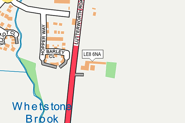
LE8 6NA is located in the Blaby electoral ward, within the local authority district of Blaby and the English Parliamentary constituency of South Leicestershire. The Sub Integrated Care Board (ICB) Location is NHS Leicester, Leicestershire and Rutland ICB - 03W and the police force is Leicestershire. This postcode has been in use since May 1994.


GetTheData
Source: OS OpenMap – Local (Ordnance Survey)
Source: OS VectorMap District (Ordnance Survey)
Licence: Open Government Licence (requires attribution)
| Easting | 456333 |
| Northing | 295808 |
| Latitude | 52.557203 |
| Longitude | -1.170516 |
GetTheData
Source: Open Postcode Geo
Licence: Open Government Licence
| Country | England |
| Postcode District | LE8 |
➜ See where LE8 is on a map | |
GetTheData
Source: Land Registry Price Paid Data
Licence: Open Government Licence
Elevation or altitude of LE8 6NA as distance above sea level:
| Metres | Feet | |
|---|---|---|
| Elevation | 70m | 230ft |
Elevation is measured from the approximate centre of the postcode, to the nearest point on an OS contour line from OS Terrain 50, which has contour spacing of ten vertical metres.
➜ How high above sea level am I? Find the elevation of your current position using your device's GPS.
GetTheData
Source: Open Postcode Elevation
Licence: Open Government Licence
| Ward | Blaby |
| Constituency | South Leicestershire |
GetTheData
Source: ONS Postcode Database
Licence: Open Government Licence
| Wright Close (Dog & Gun Lane) | Whetstone | 429m |
| Wright Close (Dog & Gun Lane) | Whetstone | 434m |
| Charles Way (Wychwood Road) | Whetstone | 458m |
| Charles Way (Wychwood Road) | Whetstone | 467m |
| Bodicoat Close (Laundon Way) | Whetstone | 623m |
| Narborough Station | 2.7km |
| South Wigston Station | 3.7km |
GetTheData
Source: NaPTAN
Licence: Open Government Licence
GetTheData
Source: ONS Postcode Database
Licence: Open Government Licence


➜ Get more ratings from the Food Standards Agency
GetTheData
Source: Food Standards Agency
Licence: FSA terms & conditions
| Last Collection | |||
|---|---|---|---|
| Location | Mon-Fri | Sat | Distance |
| Springwell Lane | 17:00 | 09:00 | 675m |
| Burnham Drive | 17:00 | 09:30 | 809m |
| Cambridge Road | 17:00 | 09:00 | 944m |
GetTheData
Source: Dracos
Licence: Creative Commons Attribution-ShareAlike
The below table lists the International Territorial Level (ITL) codes (formerly Nomenclature of Territorial Units for Statistics (NUTS) codes) and Local Administrative Units (LAU) codes for LE8 6NA:
| ITL 1 Code | Name |
|---|---|
| TLF | East Midlands (England) |
| ITL 2 Code | Name |
| TLF2 | Leicestershire, Rutland and Northamptonshire |
| ITL 3 Code | Name |
| TLF22 | Leicestershire CC and Rutland |
| LAU 1 Code | Name |
| E07000129 | Blaby |
GetTheData
Source: ONS Postcode Directory
Licence: Open Government Licence
The below table lists the Census Output Area (OA), Lower Layer Super Output Area (LSOA), and Middle Layer Super Output Area (MSOA) for LE8 6NA:
| Code | Name | |
|---|---|---|
| OA | E00129976 | |
| LSOA | E01025612 | Blaby 008C |
| MSOA | E02005340 | Blaby 008 |
GetTheData
Source: ONS Postcode Directory
Licence: Open Government Licence
| LE8 6PF | Barley Close | 128m |
| LE8 6PG | Beacon Close | 142m |
| LE8 6PD | Hopper Way | 175m |
| LE8 6QX | Elliot Close | 292m |
| LE8 6WF | Medhurst Close | 320m |
| LE8 6WG | Biggs Close | 323m |
| LE8 6WA | Charles Way | 365m |
| LE8 6WB | Coales Avenue | 382m |
| LE8 6QZ | Wright Close | 395m |
| LE8 6WE | Kinder Close | 409m |
GetTheData
Source: Open Postcode Geo; Land Registry Price Paid Data
Licence: Open Government Licence