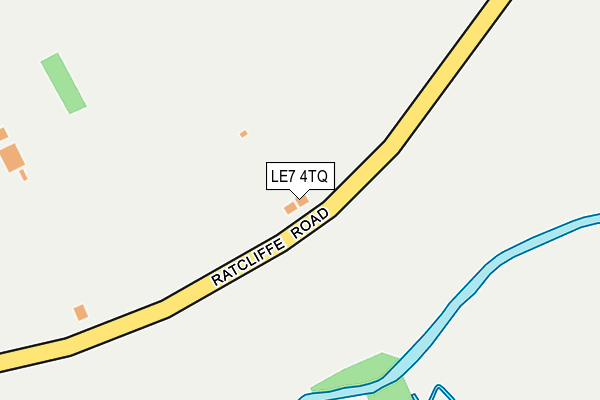
LE7 4TQ lies on Ratcliffe Road in Thrussington, Leicester. LE7 4TQ is located in the Wreake Valley electoral ward, within the local authority district of Charnwood and the English Parliamentary constituency of Charnwood. The Sub Integrated Care Board (ICB) Location is NHS Leicester, Leicestershire and Rutland ICB - 04V and the police force is Leicestershire. This postcode has been in use since August 1992.


GetTheData
Source: OS OpenMap – Local (Ordnance Survey)
Source: OS VectorMap District (Ordnance Survey)
Licence: Open Government Licence (requires attribution)
| Easting | 464307 |
| Northing | 315328 |
| Latitude | 52.731796 |
| Longitude | -1.049112 |
GetTheData
Source: Open Postcode Geo
Licence: Open Government Licence
| Street | Ratcliffe Road |
| Locality | Thrussington |
| Town/City | Leicester |
| Country | England |
| Postcode District | LE7 |
➜ See where LE7 is on a map ➜ Where is Thrussington? | |
GetTheData
Source: Land Registry Price Paid Data
Licence: Open Government Licence
Elevation or altitude of LE7 4TQ as distance above sea level:
| Metres | Feet | |
|---|---|---|
| Elevation | 60m | 197ft |
Elevation is measured from the approximate centre of the postcode, to the nearest point on an OS contour line from OS Terrain 50, which has contour spacing of ten vertical metres.
➜ How high above sea level am I? Find the elevation of your current position using your device's GPS.
GetTheData
Source: Open Postcode Elevation
Licence: Open Government Licence
| Ward | Wreake Valley |
| Constituency | Charnwood |
GetTheData
Source: ONS Postcode Database
Licence: Open Government Licence
125, RATCLIFFE ROAD, THRUSSINGTON, LEICESTER, LE7 4TQ 2000 3 NOV £145,000 |
125, RATCLIFFE ROAD, THRUSSINGTON, LEICESTER, LE7 4TQ 1996 17 OCT £88,500 |
GetTheData
Source: HM Land Registry Price Paid Data
Licence: Contains HM Land Registry data © Crown copyright and database right 2025. This data is licensed under the Open Government Licence v3.0.
| Blue Lion (Rearsby Road) | Thrussington | 764m |
| Blue Lion (Rearsby Road) | Thrussington | 773m |
| The Wheel (Melton Road) | Rearsby | 1,256m |
| The Wheel (Melton Road) | Rearsby | 1,264m |
| Horse & Groom (Melton Road) | Rearsby | 1,305m |
| Sileby Station | 4.1km |
| Syston Station | 4.7km |
GetTheData
Source: NaPTAN
Licence: Open Government Licence
| Percentage of properties with Next Generation Access | 100.0% |
| Percentage of properties with Superfast Broadband | 100.0% |
| Percentage of properties with Ultrafast Broadband | 0.0% |
| Percentage of properties with Full Fibre Broadband | 0.0% |
Superfast Broadband is between 30Mbps and 300Mbps
Ultrafast Broadband is > 300Mbps
| Percentage of properties unable to receive 2Mbps | 0.0% |
| Percentage of properties unable to receive 5Mbps | 0.0% |
| Percentage of properties unable to receive 10Mbps | 0.0% |
| Percentage of properties unable to receive 30Mbps | 0.0% |
GetTheData
Source: Ofcom
Licence: Ofcom Terms of Use (requires attribution)
GetTheData
Source: ONS Postcode Database
Licence: Open Government Licence


➜ Get more ratings from the Food Standards Agency
GetTheData
Source: Food Standards Agency
Licence: FSA terms & conditions
| Last Collection | |||
|---|---|---|---|
| Location | Mon-Fri | Sat | Distance |
| Countrymans Way | 17:00 | 09:30 | 1,640m |
| Melton Road/New Zealand Lane | 16:30 | 09:30 | 3,019m |
| Highgate Road | 16:30 | 07:30 | 3,265m |
GetTheData
Source: Dracos
Licence: Creative Commons Attribution-ShareAlike
The below table lists the International Territorial Level (ITL) codes (formerly Nomenclature of Territorial Units for Statistics (NUTS) codes) and Local Administrative Units (LAU) codes for LE7 4TQ:
| ITL 1 Code | Name |
|---|---|
| TLF | East Midlands (England) |
| ITL 2 Code | Name |
| TLF2 | Leicestershire, Rutland and Northamptonshire |
| ITL 3 Code | Name |
| TLF22 | Leicestershire CC and Rutland |
| LAU 1 Code | Name |
| E07000130 | Charnwood |
GetTheData
Source: ONS Postcode Directory
Licence: Open Government Licence
The below table lists the Census Output Area (OA), Lower Layer Super Output Area (LSOA), and Middle Layer Super Output Area (MSOA) for LE7 4TQ:
| Code | Name | |
|---|---|---|
| OA | E00130741 | |
| LSOA | E01025768 | Charnwood 008C |
| MSOA | E02005352 | Charnwood 008 |
GetTheData
Source: ONS Postcode Directory
Licence: Open Government Licence
| LE7 4SQ | Thrussington Road | 641m |
| LE7 4UJ | Blacksmiths Close | 661m |
| LE7 4UF | Ratcliffe Road | 661m |
| LE7 4UA | Ferneley Rise | 710m |
| LE7 4UD | Rearsby Road | 734m |
| LE7 4UH | The Green | 741m |
| LE7 4TP | Rearsby Road | 789m |
| LE7 4UG | Seagrave Road | 800m |
| LE7 4TS | The Green | 807m |
| LE7 4TE | Church Lane | 834m |
GetTheData
Source: Open Postcode Geo; Land Registry Price Paid Data
Licence: Open Government Licence