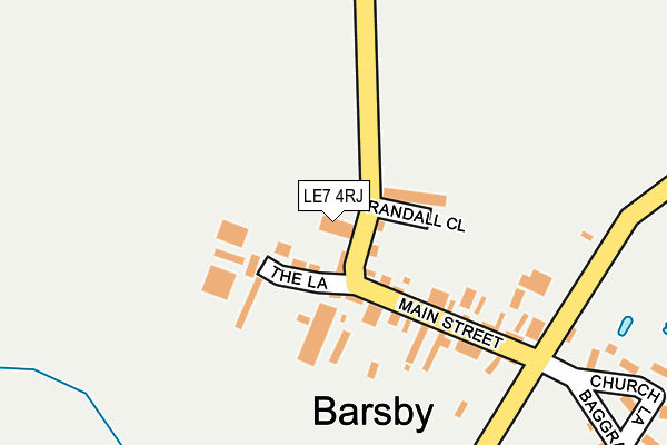
LE7 4RJ lies on King William Court in Barsby, Leicester. LE7 4RJ is located in the Gaddesby electoral ward, within the local authority district of Melton and the English Parliamentary constituency of Rutland and Melton. The Sub Integrated Care Board (ICB) Location is NHS Leicester, Leicestershire and Rutland ICB - 03W and the police force is Leicestershire. This postcode has been in use since June 2009.


GetTheData
Source: OS OpenMap – Local (Ordnance Survey)
Source: OS VectorMap District (Ordnance Survey)
Licence: Open Government Licence (requires attribution)
| Easting | 469659 |
| Northing | 311489 |
| Latitude | 52.696609 |
| Longitude | -0.970687 |
GetTheData
Source: Open Postcode Geo
Licence: Open Government Licence
| Street | King William Court |
| Locality | Barsby |
| Town/City | Leicester |
| Country | England |
| Postcode District | LE7 |
➜ See where LE7 is on a map ➜ Where is Barsby? | |
GetTheData
Source: Land Registry Price Paid Data
Licence: Open Government Licence
Elevation or altitude of LE7 4RJ as distance above sea level:
| Metres | Feet | |
|---|---|---|
| Elevation | 110m | 361ft |
Elevation is measured from the approximate centre of the postcode, to the nearest point on an OS contour line from OS Terrain 50, which has contour spacing of ten vertical metres.
➜ How high above sea level am I? Find the elevation of your current position using your device's GPS.
GetTheData
Source: Open Postcode Elevation
Licence: Open Government Licence
| Ward | Gaddesby |
| Constituency | Rutland And Melton |
GetTheData
Source: ONS Postcode Database
Licence: Open Government Licence
| Baggrave End (Croxton Road) | Barsby | 215m |
| Baggrave End (Croxton Road) | Barsby | 234m |
| Carrington Arms (Folville Street) | Ashby Folville | 1,150m |
| Carrington Arms (Folville Street) | Ashby Folville | 1,161m |
| Golden Fleece (Main Street) | South Croxton | 1,585m |
GetTheData
Source: NaPTAN
Licence: Open Government Licence
| Percentage of properties with Next Generation Access | 100.0% |
| Percentage of properties with Superfast Broadband | 100.0% |
| Percentage of properties with Ultrafast Broadband | 0.0% |
| Percentage of properties with Full Fibre Broadband | 0.0% |
Superfast Broadband is between 30Mbps and 300Mbps
Ultrafast Broadband is > 300Mbps
| Median download speed | 40.0Mbps |
| Average download speed | 46.4Mbps |
| Maximum download speed | 79.93Mbps |
| Median upload speed | 10.0Mbps |
| Average upload speed | 10.2Mbps |
| Maximum upload speed | 20.00Mbps |
| Percentage of properties unable to receive 2Mbps | 0.0% |
| Percentage of properties unable to receive 5Mbps | 0.0% |
| Percentage of properties unable to receive 10Mbps | 0.0% |
| Percentage of properties unable to receive 30Mbps | 0.0% |
GetTheData
Source: Ofcom
Licence: Ofcom Terms of Use (requires attribution)
GetTheData
Source: ONS Postcode Database
Licence: Open Government Licence


➜ Get more ratings from the Food Standards Agency
GetTheData
Source: Food Standards Agency
Licence: FSA terms & conditions
| Last Collection | |||
|---|---|---|---|
| Location | Mon-Fri | Sat | Distance |
| Main Street | 16:45 | 11:00 | 1,123m |
| Countrymans Way | 17:00 | 09:30 | 5,208m |
GetTheData
Source: Dracos
Licence: Creative Commons Attribution-ShareAlike
The below table lists the International Territorial Level (ITL) codes (formerly Nomenclature of Territorial Units for Statistics (NUTS) codes) and Local Administrative Units (LAU) codes for LE7 4RJ:
| ITL 1 Code | Name |
|---|---|
| TLF | East Midlands (England) |
| ITL 2 Code | Name |
| TLF2 | Leicestershire, Rutland and Northamptonshire |
| ITL 3 Code | Name |
| TLF22 | Leicestershire CC and Rutland |
| LAU 1 Code | Name |
| E07000133 | Melton |
GetTheData
Source: ONS Postcode Directory
Licence: Open Government Licence
The below table lists the Census Output Area (OA), Lower Layer Super Output Area (LSOA), and Middle Layer Super Output Area (MSOA) for LE7 4RJ:
| Code | Name | |
|---|---|---|
| OA | E00131376 | |
| LSOA | E01025889 | Melton 006A |
| MSOA | E02005396 | Melton 006 |
GetTheData
Source: ONS Postcode Directory
Licence: Open Government Licence
| LE7 4RQ | Randalls Close | 66m |
| LE7 4RH | Main Street | 70m |
| LE7 4RF | Church Lane | 296m |
| LE7 4RB | Baggrave End | 374m |
| LE14 2TG | Gaddesby Lane | 886m |
| LE14 2TA | Church Lane | 1088m |
| LE14 2TE | Folville Street | 1244m |
| LE14 2TP | Highfield End | 1297m |
| LE7 3RJ | Main Street | 1377m |
| LE7 4WF | Ashby Road | 1411m |
GetTheData
Source: Open Postcode Geo; Land Registry Price Paid Data
Licence: Open Government Licence