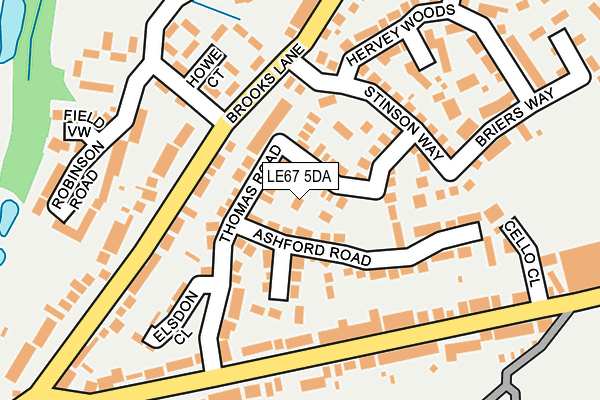
LE67 5DA lies on Geary Close in Whitwick, Coalville. LE67 5DA is located in the Hermitage electoral ward, within the local authority district of North West Leicestershire and the English Parliamentary constituency of North West Leicestershire. The Sub Integrated Care Board (ICB) Location is NHS Leicester, Leicestershire and Rutland ICB - 04V and the police force is Leicestershire. This postcode has been in use since January 1993.


GetTheData
Source: OS OpenMap – Local (Ordnance Survey)
Source: OS VectorMap District (Ordnance Survey)
Licence: Open Government Licence (requires attribution)
| Easting | 442941 |
| Northing | 316143 |
| Latitude | 52.741216 |
| Longitude | -1.365394 |
GetTheData
Source: Open Postcode Geo
Licence: Open Government Licence
| Street | Geary Close |
| Locality | Whitwick |
| Town/City | Coalville |
| Country | England |
| Postcode District | LE67 |
➜ See where LE67 is on a map ➜ Where is Whitwick? | |
GetTheData
Source: Land Registry Price Paid Data
Licence: Open Government Licence
Elevation or altitude of LE67 5DA as distance above sea level:
| Metres | Feet | |
|---|---|---|
| Elevation | 140m | 459ft |
Elevation is measured from the approximate centre of the postcode, to the nearest point on an OS contour line from OS Terrain 50, which has contour spacing of ten vertical metres.
➜ How high above sea level am I? Find the elevation of your current position using your device's GPS.
GetTheData
Source: Open Postcode Elevation
Licence: Open Government Licence
| Ward | Hermitage |
| Constituency | North West Leicestershire |
GetTheData
Source: ONS Postcode Database
Licence: Open Government Licence
| Howe Court (Brooks Lane) | New Swannington | 117m |
| Howe Court (Brooks Lane) | New Swannington | 133m |
| Church Lane (Brooks Lane) | New Swannington | 272m |
| Brooks Lane | New Swannington | 286m |
| Church Lane (Brooks Lane) | New Swannington | 293m |
GetTheData
Source: NaPTAN
Licence: Open Government Licence
| Percentage of properties with Next Generation Access | 100.0% |
| Percentage of properties with Superfast Broadband | 100.0% |
| Percentage of properties with Ultrafast Broadband | 0.0% |
| Percentage of properties with Full Fibre Broadband | 0.0% |
Superfast Broadband is between 30Mbps and 300Mbps
Ultrafast Broadband is > 300Mbps
| Percentage of properties unable to receive 2Mbps | 0.0% |
| Percentage of properties unable to receive 5Mbps | 0.0% |
| Percentage of properties unable to receive 10Mbps | 0.0% |
| Percentage of properties unable to receive 30Mbps | 0.0% |
GetTheData
Source: Ofcom
Licence: Ofcom Terms of Use (requires attribution)
GetTheData
Source: ONS Postcode Database
Licence: Open Government Licence


➜ Get more ratings from the Food Standards Agency
GetTheData
Source: Food Standards Agency
Licence: FSA terms & conditions
| Last Collection | |||
|---|---|---|---|
| Location | Mon-Fri | Sat | Distance |
| New Swannington | 16:45 | 11:30 | 353m |
| Thornborough Road | 16:45 | 11:30 | 952m |
| Belvoir Road | 18:30 | 11:30 | 1,946m |
GetTheData
Source: Dracos
Licence: Creative Commons Attribution-ShareAlike
The below table lists the International Territorial Level (ITL) codes (formerly Nomenclature of Territorial Units for Statistics (NUTS) codes) and Local Administrative Units (LAU) codes for LE67 5DA:
| ITL 1 Code | Name |
|---|---|
| TLF | East Midlands (England) |
| ITL 2 Code | Name |
| TLF2 | Leicestershire, Rutland and Northamptonshire |
| ITL 3 Code | Name |
| TLF22 | Leicestershire CC and Rutland |
| LAU 1 Code | Name |
| E07000134 | North West Leicestershire |
GetTheData
Source: ONS Postcode Directory
Licence: Open Government Licence
The below table lists the Census Output Area (OA), Lower Layer Super Output Area (LSOA), and Middle Layer Super Output Area (MSOA) for LE67 5DA:
| Code | Name | |
|---|---|---|
| OA | E00131777 | |
| LSOA | E01025969 | North West Leicestershire 007D |
| MSOA | E02005403 | North West Leicestershire 007 |
GetTheData
Source: ONS Postcode Directory
Licence: Open Government Licence
| LE67 5FY | Thomas Road | 25m |
| LE67 5HW | Victoria Close | 91m |
| LE67 5GD | Ashford Road | 114m |
| LE67 5HJ | Stinson Way | 121m |
| LE67 5FX | Elsdon Close | 160m |
| LE67 5DZ | Brooks Lane | 192m |
| LE67 5HG | Briers Way | 193m |
| LE67 5EZ | Robinson Road | 194m |
| LE67 5JA | Wakefield Drive | 198m |
| LE67 5DF | Brooks Lane | 205m |
GetTheData
Source: Open Postcode Geo; Land Registry Price Paid Data
Licence: Open Government Licence