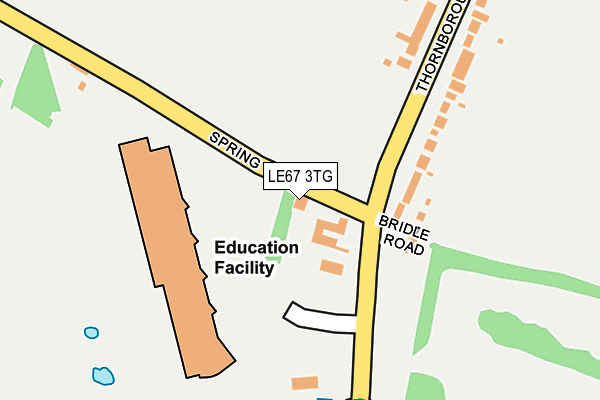
LE67 3TG lies on Spring Lane in Coalville. LE67 3TG is located in the Thornborough electoral ward, within the local authority district of North West Leicestershire and the English Parliamentary constituency of North West Leicestershire. The Sub Integrated Care Board (ICB) Location is NHS Leicester, Leicestershire and Rutland ICB - 04V and the police force is Leicestershire. This postcode has been in use since August 1992.


GetTheData
Source: OS OpenMap – Local (Ordnance Survey)
Source: OS VectorMap District (Ordnance Survey)
Licence: Open Government Licence (requires attribution)
| Easting | 442307 |
| Northing | 315399 |
| Latitude | 52.734597 |
| Longitude | -1.374871 |
GetTheData
Source: Open Postcode Geo
Licence: Open Government Licence
| Street | Spring Lane |
| Town/City | Coalville |
| Country | England |
| Postcode District | LE67 |
➜ See where LE67 is on a map ➜ Where is Coalville? | |
GetTheData
Source: Land Registry Price Paid Data
Licence: Open Government Licence
Elevation or altitude of LE67 3TG as distance above sea level:
| Metres | Feet | |
|---|---|---|
| Elevation | 150m | 492ft |
Elevation is measured from the approximate centre of the postcode, to the nearest point on an OS contour line from OS Terrain 50, which has contour spacing of ten vertical metres.
➜ How high above sea level am I? Find the elevation of your current position using your device's GPS.
GetTheData
Source: Open Postcode Elevation
Licence: Open Government Licence
| Ward | Thornborough |
| Constituency | North West Leicestershire |
GetTheData
Source: ONS Postcode Database
Licence: Open Government Licence
| Stephenson College (Thornborough Road) | Coalville | 77m |
| Stephenson College (Thornborough Road) | Coalville | 84m |
| Spring Lane (Thornborough Road) | New Swannington | 204m |
| Spring Lane (Thornborough Road) | New Swannington | 282m |
| Comet Way (Thornborough Road) | Coalville | 445m |
GetTheData
Source: NaPTAN
Licence: Open Government Licence
| Percentage of properties with Next Generation Access | 100.0% |
| Percentage of properties with Superfast Broadband | 100.0% |
| Percentage of properties with Ultrafast Broadband | 100.0% |
| Percentage of properties with Full Fibre Broadband | 0.0% |
Superfast Broadband is between 30Mbps and 300Mbps
Ultrafast Broadband is > 300Mbps
| Percentage of properties unable to receive 2Mbps | 0.0% |
| Percentage of properties unable to receive 5Mbps | 0.0% |
| Percentage of properties unable to receive 10Mbps | 0.0% |
| Percentage of properties unable to receive 30Mbps | 0.0% |
GetTheData
Source: Ofcom
Licence: Ofcom Terms of Use (requires attribution)
GetTheData
Source: ONS Postcode Database
Licence: Open Government Licence


➜ Get more ratings from the Food Standards Agency
GetTheData
Source: Food Standards Agency
Licence: FSA terms & conditions
| Last Collection | |||
|---|---|---|---|
| Location | Mon-Fri | Sat | Distance |
| Thornborough Road | 16:45 | 11:30 | 83m |
| New Swannington | 16:45 | 11:30 | 637m |
| Belvoir Road | 18:30 | 11:30 | 987m |
GetTheData
Source: Dracos
Licence: Creative Commons Attribution-ShareAlike
The below table lists the International Territorial Level (ITL) codes (formerly Nomenclature of Territorial Units for Statistics (NUTS) codes) and Local Administrative Units (LAU) codes for LE67 3TG:
| ITL 1 Code | Name |
|---|---|
| TLF | East Midlands (England) |
| ITL 2 Code | Name |
| TLF2 | Leicestershire, Rutland and Northamptonshire |
| ITL 3 Code | Name |
| TLF22 | Leicestershire CC and Rutland |
| LAU 1 Code | Name |
| E07000134 | North West Leicestershire |
GetTheData
Source: ONS Postcode Directory
Licence: Open Government Licence
The below table lists the Census Output Area (OA), Lower Layer Super Output Area (LSOA), and Middle Layer Super Output Area (MSOA) for LE67 3TG:
| Code | Name | |
|---|---|---|
| OA | E00131747 | |
| LSOA | E01025961 | North West Leicestershire 004B |
| MSOA | E02005400 | North West Leicestershire 004 |
GetTheData
Source: ONS Postcode Directory
Licence: Open Government Licence
| LE67 3GB | Bridle Road | 118m |
| LE67 3TJ | Thornborough Road | 201m |
| LE67 3TN | Thornborough Road | 314m |
| LE67 3FP | Samson Road | 461m |
| LE67 3TL | Thornborough Road | 513m |
| LE67 3TH | Thornborough Road | 519m |
| LE67 3FS | Comet Way | 535m |
| LE67 5DQ | Church Lane | 566m |
| LE67 5DL | Church Lane | 607m |
| LE67 3HE | Telford Way | 612m |
GetTheData
Source: Open Postcode Geo; Land Registry Price Paid Data
Licence: Open Government Licence