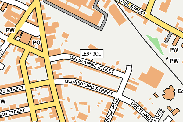
LE67 3QU lies on Melbourne Street in Coalville. LE67 3QU is located in the Coalville West electoral ward, within the local authority district of North West Leicestershire and the English Parliamentary constituency of North West Leicestershire. The Sub Integrated Care Board (ICB) Location is NHS Leicester, Leicestershire and Rutland ICB - 04V and the police force is Leicestershire. This postcode has been in use since August 1992.


GetTheData
Source: OS OpenMap – Local (Ordnance Survey)
Source: OS VectorMap District (Ordnance Survey)
Licence: Open Government Licence (requires attribution)
| Easting | 442530 |
| Northing | 314058 |
| Latitude | 52.722507 |
| Longitude | -1.371751 |
GetTheData
Source: Open Postcode Geo
Licence: Open Government Licence
| Street | Melbourne Street |
| Town/City | Coalville |
| Country | England |
| Postcode District | LE67 |
➜ See where LE67 is on a map ➜ Where is Coalville? | |
GetTheData
Source: Land Registry Price Paid Data
Licence: Open Government Licence
Elevation or altitude of LE67 3QU as distance above sea level:
| Metres | Feet | |
|---|---|---|
| Elevation | 160m | 525ft |
Elevation is measured from the approximate centre of the postcode, to the nearest point on an OS contour line from OS Terrain 50, which has contour spacing of ten vertical metres.
➜ How high above sea level am I? Find the elevation of your current position using your device's GPS.
GetTheData
Source: Open Postcode Elevation
Licence: Open Government Licence
| Ward | Coalville West |
| Constituency | North West Leicestershire |
GetTheData
Source: ONS Postcode Database
Licence: Open Government Licence
1A, MELBOURNE STREET, COALVILLE, LE67 3QU 2023 29 AUG £150,000 |
1A, MELBOURNE STREET, COALVILLE, LE67 3QU 2005 22 JUL £120,000 |
GetTheData
Source: HM Land Registry Price Paid Data
Licence: Contains HM Land Registry data © Crown copyright and database right 2025. This data is licensed under the Open Government Licence v3.0.
| Marlborough Square | Coalville | 217m |
| James Street (Outside) | Coalville | 234m |
| Marlborough Square | Coalville | 239m |
| Marlborough Square | Coalville | 241m |
| Family Centre (High Street) | Coalville | 250m |
GetTheData
Source: NaPTAN
Licence: Open Government Licence
| Percentage of properties with Next Generation Access | 100.0% |
| Percentage of properties with Superfast Broadband | 100.0% |
| Percentage of properties with Ultrafast Broadband | 97.6% |
| Percentage of properties with Full Fibre Broadband | 0.0% |
Superfast Broadband is between 30Mbps and 300Mbps
Ultrafast Broadband is > 300Mbps
| Median download speed | 80.0Mbps |
| Average download speed | 83.8Mbps |
| Maximum download speed | 200.00Mbps |
| Median upload speed | 9.8Mbps |
| Average upload speed | 10.3Mbps |
| Maximum upload speed | 20.00Mbps |
| Percentage of properties unable to receive 2Mbps | 0.0% |
| Percentage of properties unable to receive 5Mbps | 0.0% |
| Percentage of properties unable to receive 10Mbps | 0.0% |
| Percentage of properties unable to receive 30Mbps | 0.0% |
GetTheData
Source: Ofcom
Licence: Ofcom Terms of Use (requires attribution)
Estimated total energy consumption in LE67 3QU by fuel type, 2015.
| Consumption (kWh) | 502,228 |
|---|---|
| Meter count | 42 |
| Mean (kWh/meter) | 11,958 |
| Median (kWh/meter) | 10,697 |
| Consumption (kWh) | 161,718 |
|---|---|
| Meter count | 42 |
| Mean (kWh/meter) | 3,850 |
| Median (kWh/meter) | 3,029 |
GetTheData
Source: Postcode level gas estimates: 2015 (experimental)
Source: Postcode level electricity estimates: 2015 (experimental)
Licence: Open Government Licence
GetTheData
Source: ONS Postcode Database
Licence: Open Government Licence


➜ Get more ratings from the Food Standards Agency
GetTheData
Source: Food Standards Agency
Licence: FSA terms & conditions
| Last Collection | |||
|---|---|---|---|
| Location | Mon-Fri | Sat | Distance |
| Belvoir Road | 18:30 | 11:30 | 770m |
| Central Road | 17:00 | 12:00 | 1,172m |
| Central Road/Fairfield Road | 17:15 | 12:00 | 1,193m |
GetTheData
Source: Dracos
Licence: Creative Commons Attribution-ShareAlike
The below table lists the International Territorial Level (ITL) codes (formerly Nomenclature of Territorial Units for Statistics (NUTS) codes) and Local Administrative Units (LAU) codes for LE67 3QU:
| ITL 1 Code | Name |
|---|---|
| TLF | East Midlands (England) |
| ITL 2 Code | Name |
| TLF2 | Leicestershire, Rutland and Northamptonshire |
| ITL 3 Code | Name |
| TLF22 | Leicestershire CC and Rutland |
| LAU 1 Code | Name |
| E07000134 | North West Leicestershire |
GetTheData
Source: ONS Postcode Directory
Licence: Open Government Licence
The below table lists the Census Output Area (OA), Lower Layer Super Output Area (LSOA), and Middle Layer Super Output Area (MSOA) for LE67 3QU:
| Code | Name | |
|---|---|---|
| OA | E00131589 | |
| LSOA | E01025931 | North West Leicestershire 010C |
| MSOA | E02005406 | North West Leicestershire 010 |
GetTheData
Source: ONS Postcode Directory
Licence: Open Government Licence
| LE67 3QT | Melbourne Street | 23m |
| LE67 3PT | Berrisford Street | 75m |
| LE67 3PS | Berrisford Street | 98m |
| LE67 3PH | Belvoir Road | 137m |
| LE67 3PN | Belvoir Road | 157m |
| LE67 3DD | Owen Street | 172m |
| LE67 3DB | Owen Street | 209m |
| LE67 3BG | Gutteridge Street | 210m |
| LE67 3XA | New Broadway | 212m |
| LE67 3EP | Hotel Street | 215m |
GetTheData
Source: Open Postcode Geo; Land Registry Price Paid Data
Licence: Open Government Licence