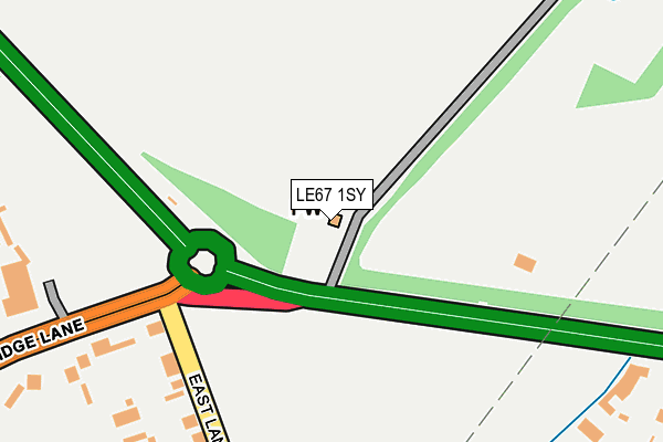
LE67 1SY is located in the Bardon electoral ward, within the local authority district of North West Leicestershire and the English Parliamentary constituency of North West Leicestershire. The Sub Integrated Care Board (ICB) Location is NHS Leicester, Leicestershire and Rutland ICB - 04V and the police force is Leicestershire. This postcode has been in use since October 2015.


GetTheData
Source: OS OpenMap – Local (Ordnance Survey)
Source: OS VectorMap District (Ordnance Survey)
Licence: Open Government Licence (requires attribution)
| Easting | 445899 |
| Northing | 311925 |
| Latitude | 52.703059 |
| Longitude | -1.322171 |
GetTheData
Source: Open Postcode Geo
Licence: Open Government Licence
| Country | England |
| Postcode District | LE67 |
➜ See where LE67 is on a map ➜ Where is Bardon? | |
GetTheData
Source: Land Registry Price Paid Data
Licence: Open Government Licence
Elevation or altitude of LE67 1SY as distance above sea level:
| Metres | Feet | |
|---|---|---|
| Elevation | 190m | 623ft |
Elevation is measured from the approximate centre of the postcode, to the nearest point on an OS contour line from OS Terrain 50, which has contour spacing of ten vertical metres.
➜ How high above sea level am I? Find the elevation of your current position using your device's GPS.
GetTheData
Source: Open Postcode Elevation
Licence: Open Government Licence
| Ward | Bardon |
| Constituency | North West Leicestershire |
GetTheData
Source: ONS Postcode Database
Licence: Open Government Licence
| Beveridge Lane (Bardon Road) | Bardon | 206m |
| Beveridge Lane (Bardon Road) | Bardon | 217m |
| Charnwood Arms (Beveridge Lane) | Bardon | 261m |
| Charnwood Arms (Beveridge Lane) | Bardon | 331m |
| Billa Barra Lane (Shaw Lane) | Billa Barra | 465m |
GetTheData
Source: NaPTAN
Licence: Open Government Licence
GetTheData
Source: ONS Postcode Database
Licence: Open Government Licence


➜ Get more ratings from the Food Standards Agency
GetTheData
Source: Food Standards Agency
Licence: FSA terms & conditions
| Last Collection | |||
|---|---|---|---|
| Location | Mon-Fri | Sat | Distance |
| Forest Road | 16:15 | 08:15 | 3,334m |
| Central Road | 17:00 | 12:00 | 3,466m |
| Central Road/Fairfield Road | 17:15 | 12:00 | 3,858m |
GetTheData
Source: Dracos
Licence: Creative Commons Attribution-ShareAlike
The below table lists the International Territorial Level (ITL) codes (formerly Nomenclature of Territorial Units for Statistics (NUTS) codes) and Local Administrative Units (LAU) codes for LE67 1SY:
| ITL 1 Code | Name |
|---|---|
| TLF | East Midlands (England) |
| ITL 2 Code | Name |
| TLF2 | Leicestershire, Rutland and Northamptonshire |
| ITL 3 Code | Name |
| TLF22 | Leicestershire CC and Rutland |
| LAU 1 Code | Name |
| E07000134 | North West Leicestershire |
GetTheData
Source: ONS Postcode Directory
Licence: Open Government Licence
The below table lists the Census Output Area (OA), Lower Layer Super Output Area (LSOA), and Middle Layer Super Output Area (MSOA) for LE67 1SY:
| Code | Name | |
|---|---|---|
| OA | E00170695 | |
| LSOA | E01033102 | North West Leicestershire 011E |
| MSOA | E02005407 | North West Leicestershire 011 |
GetTheData
Source: ONS Postcode Directory
Licence: Open Government Licence
| LE67 1TB | Beveridge Lane | 447m |
| LE67 9PW | Shaw Lane | 457m |
| LE67 1UE | Cartwright Way | 467m |
| LE67 1TG | 497m | |
| LE67 1UD | Walker Road | 527m |
| LE67 1TU | Walker Road | 563m |
| LE67 9PD | Billa Barra Lane | 600m |
| LE67 1TD | Bardon Road | 798m |
| LE67 9TA | Billa Barra Lane | 940m |
| LE67 9PU | Shaw Lane | 1171m |
GetTheData
Source: Open Postcode Geo; Land Registry Price Paid Data
Licence: Open Government Licence