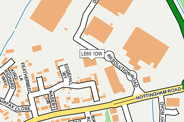
LE65 1DW is located in the Ashby Money Hill electoral ward, within the local authority district of North West Leicestershire and the English Parliamentary constituency of North West Leicestershire. The Sub Integrated Care Board (ICB) Location is NHS Leicester, Leicestershire and Rutland ICB - 04V and the police force is Leicestershire. This postcode has been in use since May 1994.


GetTheData
Source: OS OpenMap – Local (Ordnance Survey)
Source: OS VectorMap District (Ordnance Survey)
Licence: Open Government Licence (requires attribution)
| Easting | 436855 |
| Northing | 317362 |
| Latitude | 52.752640 |
| Longitude | -1.455390 |
GetTheData
Source: Open Postcode Geo
Licence: Open Government Licence
| Country | England |
| Postcode District | LE65 |
➜ See where LE65 is on a map ➜ Where is Ashby-de-la-Zouch? | |
GetTheData
Source: Land Registry Price Paid Data
Licence: Open Government Licence
Elevation or altitude of LE65 1DW as distance above sea level:
| Metres | Feet | |
|---|---|---|
| Elevation | 140m | 459ft |
Elevation is measured from the approximate centre of the postcode, to the nearest point on an OS contour line from OS Terrain 50, which has contour spacing of ten vertical metres.
➜ How high above sea level am I? Find the elevation of your current position using your device's GPS.
GetTheData
Source: Open Postcode Elevation
Licence: Open Government Licence
| Ward | Ashby Money Hill |
| Constituency | North West Leicestershire |
GetTheData
Source: ONS Postcode Database
Licence: Open Government Licence
| Birch Road (Nottingham Road) | Ashby-de-la-zouch | 188m |
| Birch Road (Nottingham Road) | Ashby-de-la-zouch | 192m |
| Tesco (Service Road) | Ashby-de-la-zouch | 212m |
| School (Nottingham Road) | Ashby-de-la-zouch | 633m |
| School (Nottingham Road) | Ashby-de-la-zouch | 686m |
GetTheData
Source: NaPTAN
Licence: Open Government Licence
GetTheData
Source: ONS Postcode Database
Licence: Open Government Licence


➜ Get more ratings from the Food Standards Agency
GetTheData
Source: Food Standards Agency
Licence: FSA terms & conditions
| Last Collection | |||
|---|---|---|---|
| Location | Mon-Fri | Sat | Distance |
| Nottingham Road | 16:45 | 11:45 | 408m |
| Market Street | 18:30 | 13:00 | 1,275m |
| Millbank | 17:30 | 12:00 | 1,294m |
GetTheData
Source: Dracos
Licence: Creative Commons Attribution-ShareAlike
The below table lists the International Territorial Level (ITL) codes (formerly Nomenclature of Territorial Units for Statistics (NUTS) codes) and Local Administrative Units (LAU) codes for LE65 1DW:
| ITL 1 Code | Name |
|---|---|
| TLF | East Midlands (England) |
| ITL 2 Code | Name |
| TLF2 | Leicestershire, Rutland and Northamptonshire |
| ITL 3 Code | Name |
| TLF22 | Leicestershire CC and Rutland |
| LAU 1 Code | Name |
| E07000134 | North West Leicestershire |
GetTheData
Source: ONS Postcode Directory
Licence: Open Government Licence
The below table lists the Census Output Area (OA), Lower Layer Super Output Area (LSOA), and Middle Layer Super Output Area (MSOA) for LE65 1DW:
| Code | Name | |
|---|---|---|
| OA | E00170702 | |
| LSOA | E01025917 | North West Leicestershire 003C |
| MSOA | E02005399 | North West Leicestershire 003 |
GetTheData
Source: ONS Postcode Directory
Licence: Open Government Licence
| LE65 1LY | Astley Way | 99m |
| LE65 1LH | Edge Hill Way | 115m |
| LE65 1LU | Cromwell Close | 176m |
| LE65 1FW | Birch Road | 179m |
| LE65 1LT | Naseby Drive | 203m |
| LE65 1LX | Featherbed Lane | 220m |
| LE65 1FX | Oak Crescent | 241m |
| LE65 1LD | King Richard Way | 254m |
| LE65 1LE | Plantagenet Way | 289m |
| LE65 1ST | Pine Close | 303m |
GetTheData
Source: Open Postcode Geo; Land Registry Price Paid Data
Licence: Open Government Licence