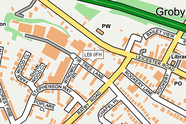
LE6 0FH is located in the Groby electoral ward, within the local authority district of Hinckley and Bosworth and the English Parliamentary constituency of Charnwood. The Sub Integrated Care Board (ICB) Location is NHS Leicester, Leicestershire and Rutland ICB - 04V and the police force is Leicestershire. This postcode has been in use since January 1980.


GetTheData
Source: OS OpenMap – Local (Ordnance Survey)
Source: OS VectorMap District (Ordnance Survey)
Licence: Open Government Licence (requires attribution)
| Easting | 452292 |
| Northing | 307516 |
| Latitude | 52.662848 |
| Longitude | -1.228268 |
GetTheData
Source: Open Postcode Geo
Licence: Open Government Licence
| Country | England |
| Postcode District | LE6 |
➜ See where LE6 is on a map ➜ Where is Groby? | |
GetTheData
Source: Land Registry Price Paid Data
Licence: Open Government Licence
Elevation or altitude of LE6 0FH as distance above sea level:
| Metres | Feet | |
|---|---|---|
| Elevation | 100m | 328ft |
Elevation is measured from the approximate centre of the postcode, to the nearest point on an OS contour line from OS Terrain 50, which has contour spacing of ten vertical metres.
➜ How high above sea level am I? Find the elevation of your current position using your device's GPS.
GetTheData
Source: Open Postcode Elevation
Licence: Open Government Licence
| Ward | Groby |
| Constituency | Charnwood |
GetTheData
Source: ONS Postcode Database
Licence: Open Government Licence
| Stephenson Close (Stephenson Way) | Groby | 115m |
| Stephenson Close (Stephenson Way) | Groby | 131m |
| Stamford Arms (Leicester Road) | Groby | 147m |
| Stamford Arms (Leicester Road) | Groby | 170m |
| Allotments (Ratby Road) | Groby | 233m |
GetTheData
Source: NaPTAN
Licence: Open Government Licence
| Median download speed | 80.0Mbps |
| Average download speed | 80.0Mbps |
| Maximum download speed | 80.00Mbps |
| Median upload speed | 20.0Mbps |
| Average upload speed | 20.0Mbps |
| Maximum upload speed | 20.00Mbps |
GetTheData
Source: Ofcom
Licence: Ofcom Terms of Use (requires attribution)
GetTheData
Source: ONS Postcode Database
Licence: Open Government Licence


➜ Get more ratings from the Food Standards Agency
GetTheData
Source: Food Standards Agency
Licence: FSA terms & conditions
| Last Collection | |||
|---|---|---|---|
| Location | Mon-Fri | Sat | Distance |
| Highfield Road | 16:00 | 08:30 | 436m |
| Laundon Way | 16:00 | 08:45 | 1,041m |
| Ratby Post Office | 16:00 | 11:30 | 2,046m |
GetTheData
Source: Dracos
Licence: Creative Commons Attribution-ShareAlike
The below table lists the International Territorial Level (ITL) codes (formerly Nomenclature of Territorial Units for Statistics (NUTS) codes) and Local Administrative Units (LAU) codes for LE6 0FH:
| ITL 1 Code | Name |
|---|---|
| TLF | East Midlands (England) |
| ITL 2 Code | Name |
| TLF2 | Leicestershire, Rutland and Northamptonshire |
| ITL 3 Code | Name |
| TLF22 | Leicestershire CC and Rutland |
| LAU 1 Code | Name |
| E07000132 | Hinckley and Bosworth |
GetTheData
Source: ONS Postcode Directory
Licence: Open Government Licence
The below table lists the Census Output Area (OA), Lower Layer Super Output Area (LSOA), and Middle Layer Super Output Area (MSOA) for LE6 0FH:
| Code | Name | |
|---|---|---|
| OA | E00131151 | |
| LSOA | E01025848 | Hinckley and Bosworth 002C |
| MSOA | E02005378 | Hinckley and Bosworth 002 |
GetTheData
Source: ONS Postcode Directory
Licence: Open Government Licence
| LE6 0FN | Firtree Walk | 58m |
| LE6 0GG | Ratby Road | 62m |
| LE6 0GF | Ratby Road | 143m |
| LE6 0FW | Stephenson Way | 158m |
| LE6 0FB | Stephenson Close | 158m |
| LE6 0FL | Markfield Road | 162m |
| LE6 0FE | Chapel Hill | 180m |
| LE6 0FY | Shaw Wood Close | 186m |
| LE6 0GH | Ratby Road | 199m |
| LE6 0FF | Bailey View | 200m |
GetTheData
Source: Open Postcode Geo; Land Registry Price Paid Data
Licence: Open Government Licence