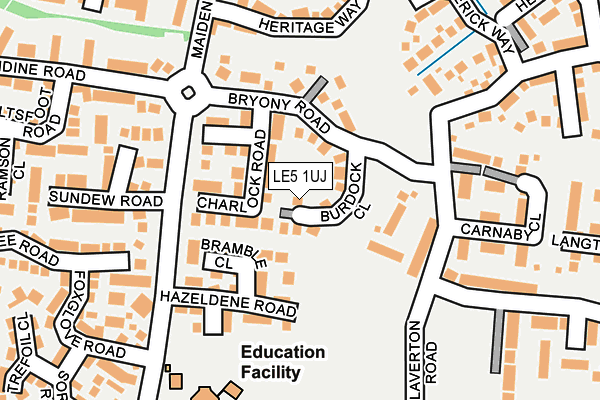
LE5 1UJ lies on Burdock Close in Hamilton, Leicester. LE5 1UJ is located in the Humberstone & Hamilton electoral ward, within the unitary authority of Leicester and the English Parliamentary constituency of Leicester East. The Sub Integrated Care Board (ICB) Location is NHS Leicester, Leicestershire and Rutland ICB - 04C and the police force is Leicestershire. This postcode has been in use since December 1997.


GetTheData
Source: OS OpenMap – Local (Ordnance Survey)
Source: OS VectorMap District (Ordnance Survey)
Licence: Open Government Licence (requires attribution)
| Easting | 463699 |
| Northing | 306847 |
| Latitude | 52.655636 |
| Longitude | -1.059752 |
GetTheData
Source: Open Postcode Geo
Licence: Open Government Licence
| Street | Burdock Close |
| Locality | Hamilton |
| Town/City | Leicester |
| Country | England |
| Postcode District | LE5 |
➜ See where LE5 is on a map ➜ Where is Leicester? | |
GetTheData
Source: Land Registry Price Paid Data
Licence: Open Government Licence
Elevation or altitude of LE5 1UJ as distance above sea level:
| Metres | Feet | |
|---|---|---|
| Elevation | 100m | 328ft |
Elevation is measured from the approximate centre of the postcode, to the nearest point on an OS contour line from OS Terrain 50, which has contour spacing of ten vertical metres.
➜ How high above sea level am I? Find the elevation of your current position using your device's GPS.
GetTheData
Source: Open Postcode Elevation
Licence: Open Government Licence
| Ward | Humberstone & Hamilton |
| Constituency | Leicester East |
GetTheData
Source: ONS Postcode Database
Licence: Open Government Licence
| Celandine Road (Maidenwell Avenue) | Hamilton | 152m |
| Celandine Road (Maidenwell Avenue) | Hamilton | 161m |
| Hazeldene Road (Maidenwell Avenue) | Hamilton | 172m |
| Hazeldene Road (Maidenwell Avenue) | Hamilton | 195m |
| Bakers Way (Maidenwell Avenue) | Hamilton | 316m |
| Syston Station | 4.6km |
| Leicester Station | 5.2km |
GetTheData
Source: NaPTAN
Licence: Open Government Licence
| Percentage of properties with Next Generation Access | 100.0% |
| Percentage of properties with Superfast Broadband | 100.0% |
| Percentage of properties with Ultrafast Broadband | 100.0% |
| Percentage of properties with Full Fibre Broadband | 0.0% |
Superfast Broadband is between 30Mbps and 300Mbps
Ultrafast Broadband is > 300Mbps
| Median download speed | 65.4Mbps |
| Average download speed | 71.3Mbps |
| Maximum download speed | 350.00Mbps |
| Median upload speed | 11.7Mbps |
| Average upload speed | 11.0Mbps |
| Maximum upload speed | 20.00Mbps |
| Percentage of properties unable to receive 2Mbps | 0.0% |
| Percentage of properties unable to receive 5Mbps | 0.0% |
| Percentage of properties unable to receive 10Mbps | 0.0% |
| Percentage of properties unable to receive 30Mbps | 0.0% |
GetTheData
Source: Ofcom
Licence: Ofcom Terms of Use (requires attribution)
Estimated total energy consumption in LE5 1UJ by fuel type, 2015.
| Consumption (kWh) | 190,706 |
|---|---|
| Meter count | 20 |
| Mean (kWh/meter) | 9,535 |
| Median (kWh/meter) | 8,745 |
| Consumption (kWh) | 46,227 |
|---|---|
| Meter count | 20 |
| Mean (kWh/meter) | 2,311 |
| Median (kWh/meter) | 1,756 |
GetTheData
Source: Postcode level gas estimates: 2015 (experimental)
Source: Postcode level electricity estimates: 2015 (experimental)
Licence: Open Government Licence
GetTheData
Source: ONS Postcode Database
Licence: Open Government Licence


➜ Get more ratings from the Food Standards Agency
GetTheData
Source: Food Standards Agency
Licence: FSA terms & conditions
| Last Collection | |||
|---|---|---|---|
| Location | Mon-Fri | Sat | Distance |
| Grantham Road | 17:00 | 12:00 | 869m |
| Maidenhead Avenue | 16:30 | 11:00 | 945m |
| Columbine Road | 17:30 | 12:00 | 1,020m |
GetTheData
Source: Dracos
Licence: Creative Commons Attribution-ShareAlike
The below table lists the International Territorial Level (ITL) codes (formerly Nomenclature of Territorial Units for Statistics (NUTS) codes) and Local Administrative Units (LAU) codes for LE5 1UJ:
| ITL 1 Code | Name |
|---|---|
| TLF | East Midlands (England) |
| ITL 2 Code | Name |
| TLF2 | Leicestershire, Rutland and Northamptonshire |
| ITL 3 Code | Name |
| TLF21 | Leicester |
| LAU 1 Code | Name |
| E06000016 | Leicester |
GetTheData
Source: ONS Postcode Directory
Licence: Open Government Licence
The below table lists the Census Output Area (OA), Lower Layer Super Output Area (LSOA), and Middle Layer Super Output Area (MSOA) for LE5 1UJ:
| Code | Name | |
|---|---|---|
| OA | E00069140 | |
| LSOA | E01032865 | Leicester 009G |
| MSOA | E02002835 | Leicester 009 |
GetTheData
Source: ONS Postcode Directory
Licence: Open Government Licence
| LE5 1RX | Charlock Road | 89m |
| LE5 1SZ | Bryony Road | 103m |
| LE5 1RW | Samphire Close | 112m |
| LE5 1UB | Bramble Close | 113m |
| LE5 1WJ | Laverton Road | 124m |
| LE5 1UA | Hazeldene Road | 143m |
| LE5 1EL | Carnaby Close | 197m |
| LE5 1ER | Catterick Way | 213m |
| LE5 1QE | Mason Row | 221m |
| LE5 1SX | Orchid Close | 225m |
GetTheData
Source: Open Postcode Geo; Land Registry Price Paid Data
Licence: Open Government Licence