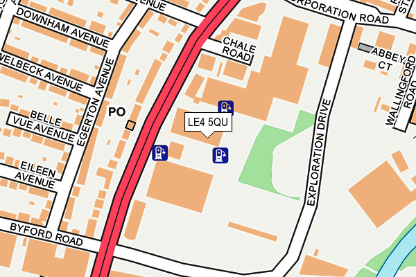
LE4 5QU is located in the Abbey electoral ward, within the unitary authority of Leicester and the English Parliamentary constituency of Leicester West. The Sub Integrated Care Board (ICB) Location is NHS Leicester, Leicestershire and Rutland ICB - 04C and the police force is Leicestershire. This postcode has been in use since January 1980.


GetTheData
Source: OS OpenMap – Local (Ordnance Survey)
Source: OS VectorMap District (Ordnance Survey)
Licence: Open Government Licence (requires attribution)
| Easting | 458539 |
| Northing | 306647 |
| Latitude | 52.654419 |
| Longitude | -1.136060 |
GetTheData
Source: Open Postcode Geo
Licence: Open Government Licence
| Country | England |
| Postcode District | LE4 |
➜ See where LE4 is on a map ➜ Where is Leicester? | |
GetTheData
Source: Land Registry Price Paid Data
Licence: Open Government Licence
Elevation or altitude of LE4 5QU as distance above sea level:
| Metres | Feet | |
|---|---|---|
| Elevation | 60m | 197ft |
Elevation is measured from the approximate centre of the postcode, to the nearest point on an OS contour line from OS Terrain 50, which has contour spacing of ten vertical metres.
➜ How high above sea level am I? Find the elevation of your current position using your device's GPS.
GetTheData
Source: Open Postcode Elevation
Licence: Open Government Licence
| Ward | Abbey |
| Constituency | Leicester West |
GetTheData
Source: ONS Postcode Database
Licence: Open Government Licence
| Chale Road (Abbey Lane) | Leicester | 92m |
| Chale Road (Abbey Lane) | Leicester | 115m |
| Byford Road (Abbey Lane) | Abbey Park | 143m |
| Byford Road (Abbey Lane) | Abbey Park | 243m |
| Abbey Lane (Beaumont Leys Lane) | Belgrave | 253m |
| Leicester North (Great Central Railway) | Birstall | 1,427m |
| Leicester Station | 2.7km |
| Syston Station | 5.7km |
GetTheData
Source: NaPTAN
Licence: Open Government Licence
GetTheData
Source: ONS Postcode Database
Licence: Open Government Licence


➜ Get more ratings from the Food Standards Agency
GetTheData
Source: Food Standards Agency
Licence: FSA terms & conditions
| Last Collection | |||
|---|---|---|---|
| Location | Mon-Fri | Sat | Distance |
| Dersingham Road | 17:00 | 12:00 | 595m |
| Ross Walk | 17:30 | 12:00 | 819m |
| Abbey Park Post Office | 17:30 | 12:00 | 1,116m |
GetTheData
Source: Dracos
Licence: Creative Commons Attribution-ShareAlike
The below table lists the International Territorial Level (ITL) codes (formerly Nomenclature of Territorial Units for Statistics (NUTS) codes) and Local Administrative Units (LAU) codes for LE4 5QU:
| ITL 1 Code | Name |
|---|---|
| TLF | East Midlands (England) |
| ITL 2 Code | Name |
| TLF2 | Leicestershire, Rutland and Northamptonshire |
| ITL 3 Code | Name |
| TLF21 | Leicester |
| LAU 1 Code | Name |
| E06000016 | Leicester |
GetTheData
Source: ONS Postcode Directory
Licence: Open Government Licence
The below table lists the Census Output Area (OA), Lower Layer Super Output Area (LSOA), and Middle Layer Super Output Area (MSOA) for LE4 5QU:
| Code | Name | |
|---|---|---|
| OA | E00169503 | |
| LSOA | E01013607 | Leicester 008B |
| MSOA | E02002834 | Leicester 008 |
GetTheData
Source: ONS Postcode Directory
Licence: Open Government Licence
| LE4 0DA | Abbey Lane | 121m |
| LE4 5JD | Exploration Drive | 157m |
| LE4 0DL | Egerton Avenue | 171m |
| LE4 0DN | Egerton Avenue | 178m |
| LE4 0DB | Abbey Lane | 210m |
| LE4 0DS | Sudeley Avenue | 211m |
| LE4 0DQ | Egerton Avenue | 218m |
| LE4 0DP | Egerton Avenue | 224m |
| LE4 5NU | Exploration Drive | 235m |
| LE4 0EE | Welbeck Avenue | 259m |
GetTheData
Source: Open Postcode Geo; Land Registry Price Paid Data
Licence: Open Government Licence